.png)

Introduction
Theoretical framework
Research on the Roman road network should adopt a multidisciplinary perspective, tailored to the specific needs of each case study. Identifying a Roman road, as distinct from movement corridors or later Medieval and Modern roads, as well as understanding the transformation of the territory itself, presents problems that remain consistent throughout any research on road networks.
This issue is particularly evident when dealing with legacy data, especially in projects where the methodology depends on measuring distances of itineraries and proposing sites or locations as milestones based on varying criteria and methodologies. Such approaches often rely on elements that are difficult to date, such as bridges, or consider features that may have shifted over time, as is the case with milestones.
In contrast, contemporary perspectives utilize the capabilities of novel methodologies to correlate geography and history. Geographical Information Systems (GIS), as is well documented, have become a fundamental element of archaeological methodology in researching road networks and historical landscapes (Lock and Stančič 1995; Parcero-Oubiña 2018, pp. 55–70). Frequently, this geospatial methodology addresses issues such as optimal routes, transport costs, network analysis, and population dispersion. Territorial analysis serves as an ideal context for the application of GIS, allowing researchers to employ a variety of geographic analysis tools (Zamora 2016, pp. 347–359; Mayoral et al. 2017; Carrero 2023). Geospatial technologies enable the calculation of specific data, such as the optimal routes between two points—commonly referred to as Least Cost Paths (LCP)—when moving through the territory. They also support network analyses that interconnect information, identifying optimal sites for secondary accesses or shedding light on political or economic factors (Prignano et al. 2019). This is achieved while considering the position and proximity of water sources, road construction, production areas, relative distances, and resource availability (Parcero-Oubiña, 2018, pp. 55–70). In summary, GIS facilitates the generation of economic and logistical optimization models, aligned with principles of modern efficiency (Bosque et al. 1999, pp. 295–323). For ancient roads, it aids in reinterpreting routes and producing new cartographies, by identifying the route and associating it with relevant sites (González-Crespán 2018, pp. 1–26).
Nevertheless, attempting to refine proposals based on pre-GIS studies by integrating modern methods can be misleading. This is because such efforts risk merely pursuing an improved correlation of pre-existing hypotheses without achieving any significant advancement. In this article, we propose a methodology to address this challenge. Our approach incorporates spatial criteria, including topographic and non-Euclidean correlations, to reassess prior layouts and proposals. This fosters a more thorough examination of the topic.
Proposed approach: A case of study
To illustrate this problem and offer ways to address it, we present the following case study focused on the Galician territory. We consider the application of GIS not only necessary but also innovative for obtaining new data, expanding beyond the perspective offered by historical sources and archaeological evidence. Through this approach, it will be possible to understand the territory of Gallaecia from a fresh perspective, allowing the development of new working hypotheses to reliably analyze the factors that Roman engineers might have considered appropriate when designing road XIX.
The purpose of this article is not to predict the locations of spaces or mansions, but rather to clarify the state of research by employing a new methodological approach. Many historiographical issues tend to focus repeatedly on the same processes. This is often the case in tracing Roman roads, where debates commonly rely on interpretations of itineraries and archaeological discoveries. With the straightforward and reproducible methodology, we propose, these issues can be partially addressed, synthesizing more than 150 years of research from a spatial perspective.
In the context of present-day Galicia, our knowledge of the Roman roads derives from several written sources that describe itineraries. However, much of this knowledge also stems from archaeological exploration, which has helped to identify and confirm the routes of some roads, while revealing other previously unknown paths overlooked by written sources. Nevertheless, after analyzing the current state of research, we perceive significant gaps in knowledge, as traditional archaeological methodologies have been predominantly applied (Abasolo 1990, pp. 7–20). The application of Geographical Information Systems (GIS) or noninvasive archaeological techniques has not yet been explored in relation to the road networks traversing Gallaecia. This refers specifically to roads XVIII, XIX, and XX. By contrast, there is a study focused on highway XVII, from Bracara Augusta to Asturica Augusta, through Portuguese territory (Fonte et al. 2017, 163–189). In that study, Fonte et al. argue that optimal layouts should not be the sole criterion for elucidating road configurations. We agree with this perspective and emphasize that following optimal paths is far from the only consideration.
Our study is grounded in a thorough examination of the human factors that shaped the organization of the territory and the establishment of multiple priority routes. Thus, while cost factors and optimal routes are included in this research, they serve as complementary elements rather than sole determinants. Our work does not aim to analyze road layouts but to identify tools that recognize certain characteristics defining a Roman road (Nión-Álvarez 2022). For this reason, we consider GIS a valuable tool that opens up vast opportunities for research, highlighting the lack of cutting-edge studies compared to other peninsular territories. This is why, in the present study, we apply Geographic Information Systems techniques to address the ongoing debate surrounding the layout of road XIX.
Landscape setting: the Roman Galicia
Gallaecia was originally the given by the Romans to describe the territory located at the Northwestern end of the Iberian Peninsula, a Roman province that encompassed the territories of the current autonomous community of Galicia, northern Portugal and the territory of the current provinces of León, Zamora and Asturias. The territory was inhabited by Indo-European peoples with a Celtic language called Galicians (gallaeci), to the west, and Asturians to the east (Fig. 1).
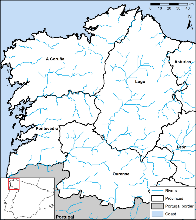
Territory of current Galicia (Spain), in the Northwest of the Iberian Peninsula. The map represents the 4 provinces which are included in the Autonomous Community of Galicia
The beginning of the Romanization of Galicia is usually dated with the expedition of Decimus, the Galaico, and the landmark of crossing the river Lethes (Limia). Throughout the first century, trade became established, mainly on the coast, accompanied by several military expeditions. The territory belonged first to the province of Lusitania, then to Tarraconensis and finally Gallaecia was constituted, already in the third century. This was divided into three juridical convents (demarcations): Bracarensis, Lucensis and Asturicensis (Arias 1992). Regarding the orography of this region, mountains largely dominate the valleys and plains, while the coastal corridor has been consistently navigable throughout history. However, certain areas, such as river crossings or specific mountain passes, posed significant challenges.
Mansiones in the classical sources
The Antonine Itinerary includes the XIX Route from Braga to Astorga, passing through Galician territory through the Pontevedra province, from South to North, and those routes from A Coruña and Lugo from West to East to Lugo capital, continuing from there to the Southeast in the direction to El Bierzo.
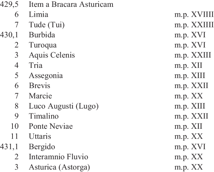
The itinerary lists the towns and mansiones along the way, naming the distances in miles. This document from the third century has undergone several copies, from the 7th to the fifteenth centuries, which are the versions that have survived to the present day, potentially with some modifications to the original. We have several critical editions published since the seventeenth century, among which the successive editions by P. Wesseling (1735), Parthey and Pinder (1848), and, finally, the one of Cuntz (1929) stand out.
State of art
The State of the art on the XIX road, allows us to introduce the problem of distances and the difficulty of identifying mansions (Table 1). As a result of the disparity of opinions, there are several hypotheses of the layout of the road, for our case study from the mansiones of Tude to Luco Augusti. The starting references are based on the distances in the Antonine Itinerary: Tude-Burbida: 16 miles; Burbida- Turoqua: 16 miles; Turoqua- Aquis Celenis: 14 miles; Aquis Celenis- Tria: 12 miles; Tria- Assegonia: 23 miles; Assegonia- Brevis: 12 miles; Brevis- Marciae: 20 miles; Marciae- Luco Augusti: 13 miles for a total of 123 miles. The attached table presents chronologically the proposals for the positioning of the mansiones and the drawing of the road layout from years 1863 to 2018, the most recent one, having selected the 12 most relevant works, which only coincide in the initial positioning of Tude (Tui) and Luco Augusti (Lugo).
The Gallician historiographical road publications (Argüelles and Villanueva 2024, pp. 117–144) present the first studies on the XIX road date back to 1839 with the Summary of Roman Antiquities by J.A. Céan-Bermúdez (1836), although the most detailed and pioneering description of the road corresponds to E. Saavedra (1863). His proposal is supported almost entirely with minimal changes, by R. Barros (1875, pp. 163–165). The main contribution of A. Blázquez y Delgado-Aguilera (1918a, pp. 5–24; 1918b, pp. 118–127) is to analyse the inland route from Bracara Augusta to Luco Augusti through the Orense province. Thus, he carried out the calculations using equations and trigonometry to ascertain what the mile distance would be the correct one for the road, in order to meet the identification of the mansions according to the classical sources and the studies that preceded this researcher. That is, the famous 1481 m for one mile. We see how in this case the mansiones of Aquis Celenis and Assegonia differ from the previous works. A. Blázquez y Delgado-Aguilera proposes the metrical problem of the mile, accepting for the Galician case a distance of 1000 m per mile and not 1481 m, which would be the average reference in Hispania.
A. Blázquez-Jiménez (1923, pp. 10–18) proposes the layout which meets his predecessor´s in the first five mansiones, although in the case of Assegonia and Brevis he proposes new locations. The proposal of S. Gómez (1931, pp. 70–71) keeps the same working line as the aforementioned A. Blánquez y Delgado-Aguilera, although it differs for the location of Aquis Celenis and Assegonia.
In the case of L. Monteagudo (1951, pp. 191–255; 1953, pp. 91–99) and in relation to Galician roads, he reviews and corrects Ptolemy's coordinates. Identifying the position of ancient cities. He does not draw the path directly, but we can mark it, based on his studies. For this reason, it is striking that he places the Turoqua at such a short distance from Tude, which would not fit at all with the distances of the Antonine Itinerary, although that of Burbida is not referenced.
M. D. Estefanía (1960) agrees with A. Blánquez y Delgado-Aguilera and A. Blázquez-Jiménez on the route to Aquis Celenis, so that is the first part of the path, in North direction. On the other hand, the study presented by G. Arias (1987, pp.14–26; 1988, pp. 15–18) proposes for the first time a different location for Burbida and the rest of the mansions, matching only in the case of Aquis Celenis with some previous authors.
A. de la Peña (1990, pp. 217–243) studies the road in the Pontevedra area, so we do not know his proposal for the complete layout to Lugo. We can see how he offers two new locations, for the first two mansiones of Burbida and Turoqua, although the mansiones of Tria and Assegonia match with the proposals of the authors of the late nineteenth century.
B. Sáez, on the other hand, follows the metric of 1481 m (Sáez 2001, pp. 31–33; 2002, pp. 389–401) and offers us a new proposal for the case of Burbida and Turoqua, although the rest of the route would coincide with the study of A. Blánquez and Delgado-Aguilera (except also in the mansio of Marciae).
One of the most recent works corresponds to R. Villanueva (Villanueva 2006, pp. 25–36; 2008, pp. 74–99). This author establishes as the foundations of his theory to refute the proposal of A. de la Peña to reject and propose his route. It would coincide in the mansiones of Burbida, Turoqua, Aquis Celenis, and Marciae with the study of R. Barros, although Tria, Assegonia and Brevis, he considers that they are poorly positioned in the previous studies and offers three new positions. Undoubtedly, the debate of being able to position the mansiones with certainty and offering the exact layout of the roads is the object of study not only of researchers on roads, but also in territorial studies, where the need to understand the road structure is fundamental, as is the case of the reflections made by B. Currás (2014, pp. 858–879), which, although it does not study the road XIX per se, criticizes he does criticize and reinterpret the works published so far.
This historiographical debate concludes with the most recent published work by C. M. González-Crespán (2018, pp. 93–110). This author does not agree with the route designed by the previous researchers, although he accepts some of their positions. For example, regarding the mansio of Burbida, he agrees with the theory of G. Arias, about Aquis Celenis, he would agree with R. Villanueva, L. Monteagudo, S. Gómez, R. Barros, and E. Saavedra. For the case of Tria, he accepts the theory of his predecessor R. Villanueva, while the remainig mansiones, despite the existence of so many proposals, he considers have been erroneously positioned.
Methods and theory
From a theoretical point of view, the approach presented in this article is simple but effective. The potential modeling of these spaces through complex and predictive models has been discussed (Verhagen et al. 2013; Brughmans 2013; Citter 2023). There is also the possibility of calculating not only land routes, as the case may be of road XVII (Fonte et al. 2017, pp.163–189), but also maritime routes (Milheira et al. 2019; Trapero 2021).
In our specific case study, the focus is on terrestrial mobility within a region characterized by particularly rugged terrain, a result of pronounced orography. In such challenging environments, it becomes imperative for routes to align with natural paths (as emphasized by Carreras et al. 2019). Our approach centers on the practical ability to measure distances in a Euclidean manner, a methodology that has been conventionally employed in historiography. It must be understood that measuring distances on a satellite view map, as has been done recently, is not the method used in antiquity, where measurements were made based on the distance and the time it took to travel an itinerary. While this approach may be suitable in cases where the topography is relatively flat and lacks prominent features such as mountains or rivers, its applicability diminishes significantly in areas characterized by steep slopes.
In regions with such a challenging terrain, the conventional practice of measuring distances on a map without factoring in angles and slopes proves to be impractical. Therefore, our methodology advocates for a more nuanced consideration of topographic features, by incorporating the measurement of angles and slopes, to provide a more accurate and contextually relevant understanding of terrestrial mobility in these rugged landscapes.
To address these issues through topography, we have identified locations considered as stops along the route, using the toponyms provided by ancient sources and placing them where previous researchers have considered. We used a digital elevation model, provided by the Spanish Ministry through the National Geographic Institute. Given that the study area exceeds 15,000 square kilometers, we used a 25-m pixel model. The dataset covers the whole Galician region, resulting in an intermediate resolution. The elevation model has been reviewed to ensure that it represents the terrain with corrected anthropogenic constructions.
For analysis purposes, we employed ArcGIS Pro software. Two methodologies were developed at a technical level, both of which require the prior generation of a friction map. This map was created based on topography, represented by slope degrees. The hydrographic network was calculated using hydrographical tools and classifying the main flow accumulation lines at a high threshold (100,000) and converting them into polylines. This threshold has been chosen through trial and error, considering that we are taking into account the main rivers of the area. It should be noted that the Galician hydrographic system consists of small but torrential rivers due to plenty of rainfall. This, combined with the topography, creates estuaries and short rivers. The aim was to create a 50-m buffer and convert it back into a raster, thus generating an artificial mountain range with a slope ranging from 10 degrees after reclassification, with null values, now quantified as 0. This is a simple process, described in other methodological articles (Parcero-Oubiña et al. 2019, pp. 1-191; Trapero 2021; Trapero and Carneiro 2023). Its purpose is to limit mobility through the rivers, as these tools naturally tend to consider rivers as "highways" for water navigation. To address this, simply using a linear limiter was not sufficient. This is because these rivers are wide and limiting them with a central line leaves pixels of areas that, in fact, are difficult to cross, thereby retaining the same problem. Therefore, we use the 50-m one (considering that we use a 25-m raster, to ensure at least 2 pixels) and apply a slope factor. This value of 10 degrees was established after several trials, increasing the factor from 2 to 5, 8, and 10. The starting results clearly showed a preference for crossing or navigating the rivers, due to the rough topography of the area.
Subsequently, the slope raster was added to the river channel limitation raster, using the field calculator. This prevents preferential movement along river stretches. Manual correction was necessary, especially in areas such as the Portodemouros reservoir. Here, the topography was adjusted to partially impede movement, by extracting a figure from the current reservoir and restricting the passage through it.
Two analyses were conducted with this approach. The first used a tool named MADO (Modelo Acumulado de Desplazamientos Óptimos or Focal Mobility Networks) (Fábrega 2006; Llobera et al. 2011), developed precisely to visualize territorial issues when the destination is unclear. In this case, three secure points on the territory were used: Tui (Tude), on the other bank of the Miño river, the city of A Coruña (Brigantium), and Lugo (Luco Augusti). This triangle represents the main points to be connected in this territory. With this methodology, we have calculated the cost map (Least Cost Path), and the flow direction and accumulation, providing a representation of the natural corridors, from these points to the remaining territory. The accumulation of routes generated by the three points results in a theoretical and preliminary map of the best routes.
The other analysis carried out is the cost of distance and the optimal route between the different points considered as stops along the route. This involves calculating a point on the itinerary and defining the best topographic route from this point to the possible subsequent stops. This process is repeated for each of the routes, creating a network of potential paths.
The method uses the same friction raster already tested in the previous model. Although there are other ways of performing the calculations (Lewis 2023), we have opted for the simplest and most reproducible approach, comparing two methods: MADO (Modelo Acumulado de Desplazamientos Óptimos) and LCP (Least-Cost Path). The MADO allows us to determine the best optimal paths across the territory, while the LCP one enables us to connect points that we consider relevant to our study.
Results
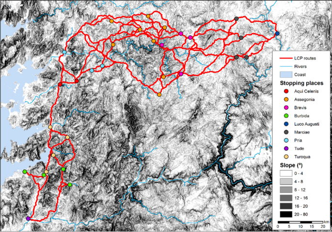
The spatial arrangement of the main stops considered by the previous authors, reveals a significantly different distribution of sites in the territory. In our analysis, we have omitted some points that were considered very close to others, such as the case of Puente de Meyjaboy with Marzán or Iría Flavia with Padrón (Fig. 2).
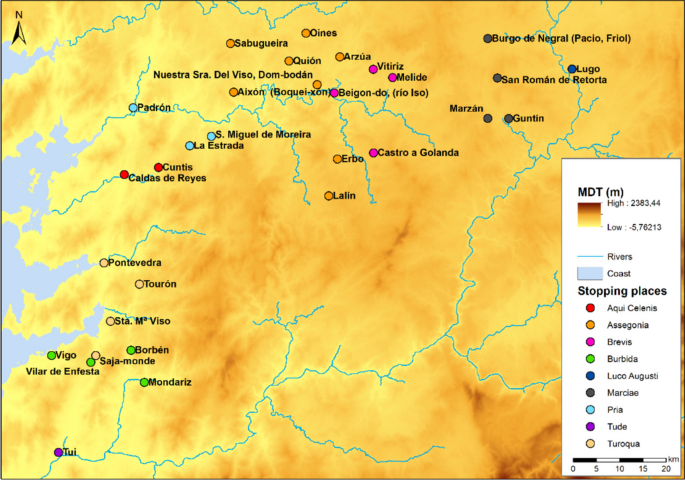
Positions for each of the mansions in the Antonine Itinerary according to the various published studies. The position of each of the mansions can be found in different colors according to the authors consulted. Hence, the positions differ and there is no agreement in the study of the Road XI from Tude in Pontevedra province to Lucus Augusti in Lugo province
If we compare these results with the starting MADO analysis, we can notice how the optimal paths connecting the territory only match with specific segments of the proposed stops. This is due to two issues: The first one is the slope of the terrain, which rises from barely 50 m at Tui to 650 m at Lugo. It is essential to consider that only 24% of the terrain is flat, with less than a 4º slope, 42% with a 4–12º slope, 21% with a 12–20º slope, and 14% of the territory with slopes higher than 20º. This general trend in the Galician territory, the heart of the area under study, makes mobility difficult, with only a few natural paths. Additionally, this implies that the MADO analysis shows indirectly the three main corridors to connect the three cities that controls the territory: Bracara Augusta, Brigantium, and Luco Augusti (as noted above) (Fig. 3). This means that the MADO model used here, provides us with the main corridors, because the geography of the terrain is quite variable in both topography and slope. The natural passes are what they are and, therefore, the chosen communication routes must be within these areas.
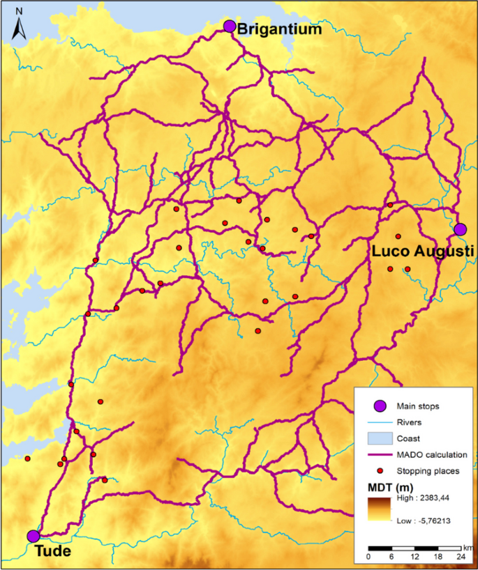
Optimal routes on Gallaecia territory (Pontevedra, Coruña, Lugo), using MADO tool. This figure represents indirectly the three main corridors to connect the three cities that controls the territory like Tude (Tui), Lucus Augusti (Lugo) and Brigantium (A Coruña)
The second consideration is that, clearly, the topography has not been considered in the interpretations of the possible stops, as there are possibilities that are far from the main corridors. To address this, we have conducted a second analysis of them, together with cost routes. This way, the aim is connecting each potential stop to the next possibility (Fig. 4).
Least- Cost Path routes proposed for the studied territory in Pontevedra, Coruña and Lugo. The aim of this results is is connecting each potential stop to the next possibility taking into account the MADO results and the topography distances
In this map, the optimal paths are nearly unique, at the beginning from Tude to Aquis Celenis, with only one of the possible movements considered in one case. This implies that the territory is so challenging to traverse that those options are limited. In the case of the West–East route to Luco Augusti, the problem is more significant, as there are more possibilities, along with an increased distance.
The process of proposing an optimal route has relied on topographical considerations to define the corridors. In Fig. 5, a detailed view of the beginning of the road between Tude and Burbida is shown.
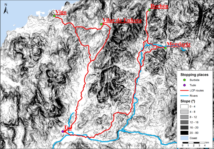
Detailed view from Tude to Burbida with Least-Cost Path. This figure represents a detailed example of the connectivity between the first two mansions fro Tude to Burbida (Pontevedra province) in relation with the 4 positions that other researchers have proposed
In this case, by visualizing the terrain slopes and other features such as rivers, it becomes evident that mobility through the territory can only be achieved through the two corridors outlined as optimal ones. This implies that, in this particular case study, the optimal paths resemble closely the surveyor's choice, when selecting routes, because there are no other viable options. In this regard, calculating not just the antropic distance, without considering the slope but the accumulated cost with topography, means that not all paths adhere to the distance provided by the itineraries.
In Table 2, the distance correlation between different stops can be observed after the route has been corrected, according to topography.
The average distance value is longer than the theoretical mile of 1481 m, but close to that figure and relatively constant in all cases (1515–1550 m):
-
Burbida, Vilar de Enfesta, 24,400 m (mile at 1525).
-
Turoqua, Pontevedra, 24,500 m (mile at 1531).
-
Aquis Celenis, Caldas de Reyes, 21,500 m (mile at 1535).
-
Tria, La Estrada, 18,600 m (mile at 1550).
-
Assegonia, Quión, 35,800 m (mile at 1556).
-
Brevis, Vitiriz, 18,500 m (mile at 1541).
Up to this point, all sites are consistent with the distances, with an average deviation of about 40 m per mile. This discrepancy could be attributed to variations in the pattern or the calculation error with the optimal route, which is negligible. Therefore, we present this section without hesitation.
The problem remains unresolved at the end of this stretch, as none of the mansiones align perfectly:
-
Marciae, San Román de la Retorta, 32,300 m (mile at 1615).
-
Luco Augusti, Lugo, 20,500 m (mile at 1576).
We believe that San Román is the most optimal, precisely because the calculations from Luco Augusti and Brevis are the closest. The itinerary would be arranged as follows, as depicted in Fig. 6.
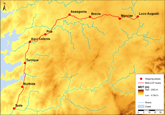
Proposed optimal route for road XIX (Tude—Luco Augusti) of the Itinerary of Antonini between Pontevedra and Lugo
Based on this information, we can propose that this is the best layout, according to topography, but we need to compare it with archaeological information. By selecting archaeological elements present in the territory, and considering only those ones that provide information about a road (milestones in situ, excavated road remnants, bridges, or other elements from relevant locations such as hillforts, forts, or thermal complexes that could be potential stops on a road), we can assess the alignment. In the North–South stretch along the coast, there is no problem, due to the plenty of information provided by milestones. In the West–East stretch, we have summarised the main contributions in Fig. 7.
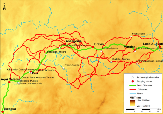
Global map with best routes on basis of Least- Cost Path, archaeological remains and authors´ proposed route. The representation includes all the mansions for the proposed case of study including the provinces of Pontevedra, Coruña and Lugo
As can be noticed, our optimal path is very close to key landmarks in the territory, which provide information about the routes, such as the Taobada bridge, the Cuntis thermal baths (another possible mansio that would also be passed through), the toponym "A Estrada", and the Roman camp located there, the Boqueijón milestone, the Furelos bridge, and the Caligula milestone in S. Román de la Retorta. There can only be uncertainty in three cases. The first one, which is highly unlikely, is the Freixo bridge, isolated and outside from any optimal route. The second is the path to the Friol milestone, which also deviates from the main routes. Only the possibility of passing through the Curbían thermal baths, towards the milestone found in Entrambasaguas, would make sense for the route to Guntín. In this case, this possibility is less likely, since the Curbían thermal baths would not be a mansio by themselves. All these paths could well be other secondary networks that we are not aware of. Specifically, it might be worth considering whether the milestones of Friol, S. Román de la Retorta, and Entrambasaguas are not parts of the Northeast-Southwest Road that goes from A Coruña (Brigantium), to the South.
In Fig. 7, some relevant milestones associated with the territory through which the road is described have been indicated. It is undoubtedly striking that these are not located marking what would be the optimal layout proposed through the applied methodologies. The issue, without a doubt, is that the milestones can be moved. We are not referring to the fact that many of the milestones located in Gallaecia have not been found in situ, but in contexts of reuse, or they could belong to secondary branches. Therefore, when the milestone offers data on distances or cities it is a key element in the study, but for example, when they are anepigraphs their relevance is less (Rodríguez et al. 2004).
Discussion
The results of the analysis show clearly that, among all the scrutinized proposals, only those ones aligning with topographical distances hold a merit. This dismisses effectively alternative possibilities that deviate significantly from the metrics provided by the examined itineraries.
This prompts a crucial question that impels further investigation: Was there a realistic technical capacity in ancient Rome, to precisely measure distances? And, could this happen considering especially the topographical intricacies of the terrain? The proposal emerges from the metrics found in historical itineraries that might be regionally contingent, as empirical evidence suggests a misalignment with the present geographical reality. Consequently, a re-evaluation of the problem is suggested, leaning towards a Geographic Information System (GIS) study. Such a study could provide a more nuanced understanding, by incorporating precise distances, based on potential breaks in the orography; thereby offers a more accurate depiction of historical mobility patterns. This avenue for future research holds the potential to deepen our comprehension of the technological capabilities and spatial awareness of ancient civilizations.
The application of GIS to reconstruct Roman road systems has significantly advanced our understanding of ancient transportation networks. Previous studies, such as Carreras et al. (2019), highlighted the potential of network analysis and least-cost path modeling in mountainous regions like the Alps and Pyrenees. Similarly, Parcero-Oubiña et al. (2019) explored GIS methodologies to model Roman routes using physical evidence and terrain data. However, these approaches often risk perpetuating pre-GIS hypotheses without achieving a meaningful reassessment of underlying principles. Our methodology addresses this limitation by incorporating spatial criteria, including topographic and non-Euclidean correlations, to reassess and refine prior layouts. While studies like Fonte et al. (2017) have effectively used GIS to evaluate the rationale behind Roman road placement, such work often aligns closely with traditional interpretations. Similarly, the ORBIS project (2012) simulates Roman connectivity through a geospatial network model, but its primary focus remains on reconstructing movement rather than reexamining entrenched layouts.
Unlike these previous approaches, our methodology integrates broader spatial dimensions. For instance, Prignano et al. (2019) analyzed terrestrial networks to study inter-polity interactions, yet their focus on political dynamics lacked the multidimensional spatial criteria our method incorporates. Likewise, Verhagen et al. (2013) combined least-cost paths and network analysis to predict settlement locations, offering valuable insights but limiting their scope to linear correlations. Our approach also diverges by integrating hydrological and landscape-ordering data, as emphasized by Milheira et al. (2019), to foster a more holistic analysis. This integration not only refines the spatial accuracy of reconstructions but also allows for a deeper critique of historical assumptions. By leveraging these capabilities, our method transcends mere validation of past proposals, enabling more innovative and comprehensive interpretations of Roman road systems.
The methodology employed in this study offers a robust framework for reconstructing and analyzing Roman road networks. However, it is essential to critically reflect on its limitations and the challenges inherent in archaeological data and GIS-based modeling. One significant consideration is the inherent bias in archaeological datasets, which are shaped by depositional and post-depositional processes. Roman road remains are often incomplete, affected by centuries of natural erosion, agricultural activity, and modern infrastructure development. These processes can lead to gaps in the physical evidence, potentially skewing route reconstructions. For instance, milestones, a critical element in identifying Roman roads, may have been relocated or repurposed, which can introduce spatial inaccuracies. Acknowledging these biases is vital for interpreting results cautiously and for integrating supplementary data to verify reconstructions.
Another key issue is the omission of secondary roads or seasonal paths that might have played a crucial role in regional mobility. The focus on primary routes, often guided by the visibility of major archaeological features, risks overlooking smaller but equally significant components of the Roman transportation network. Addressing this requires a more inclusive approach that incorporates diverse datasets, such as toponyms, historical maps, and environmental indicators, to identify less visible paths.
Uncertainty in GIS-based modeling is another challenge. Although Least-Cost Path (LCP) analysis is a powerful tool, its reliance on simplified assumptions, such as uniform terrain accessibility or cost factors, may not fully capture the complexity of ancient route planning. By integrating non-Euclidean correlations, including cultural and economic factors, as discussed in studies like Prignano et al. (2019), we can enhance the accuracy of reconstructions. However, these integrations introduce additional layers of complexity that require careful calibration and validation against archaeological evidence.
Despite these challenges, the methodology's strengths lie in its flexibility and adaptability to various landscapes. This study highlights the importance of a critical and iterative approach to ensure that GIS-based models not only replicate plausible routes but also contribute to broader archaeological questions about connectivity, mobility, and regional integration in the Roman Empire.
From a technical perspective, our methodology diverges from traditional applications of LCP analysis by explicitly adapting its principles to the complexities of historical reconstructions. Originally developed for modern infrastructure planning, LCP models often assume consistent and quantifiable cost factors, such as road conditions and direct economic benefits, which are not directly translatable to ancient contexts. In Roman road studies, cost parameters must account for variables such as ancient engineering techniques, topographic constraints, and sociopolitical considerations, which are inherently less quantifiable and more variable across regions.
For instance, while studies like Fonte et al. (2017) effectively used LCP to trace the rationale behind Roman road placement, our approach extends this by integrating non-Euclidean factors, such as cultural landmarks and administrative priorities, to refine the models. Additionally, we address the challenge of incorporating incomplete or biased archaeological data, a common issue in historical reconstructions, by cross-referencing physical evidence with historical and environmental data. These adaptations mitigate the risk of oversimplifying ancient decision-making processes, enhancing the relevance and accuracy of our models.
Conclusions
Despite the existence of a large bibliography that addresses the question of the positioning of the mansiones on Road XIX to offer the possible road layout. The proposal we offer is presented for the first time with an unprecedented and innovative study, approached from the perspective of Geographic Information Systems. In this way, using the Least-cost Path and MADO tools, the most optimal route has been proposed based on both the terrain and the archaeological findings and, above all, the reference of the distances of the mansions in the Antonine Itinerary.
Therefore, with the results shown, we consider that it is a valid route that allows us to resolve the debate presented on the different sites for the same mansio, which has been proposed by all the authors before us.
Thus, it can be noticed that the route of the XIX road named in this study, does not completely match totally with any of the previous investigations and the values recorded by the GIS tool, when considering the proposal of Tui, Villar de Enfestas, Pontevedra, Caldas de Reyes, La Estrada, Quión, Vitiriz, San Román de la Retorta and Lugo as an optimal route. It matches partially, therefore, with different authors, depending on the proposed position. According to the order of the mansiones from Tui to Lugo, we agree on the South-North layout, the case with the theory of A. de la Peña with Burbida, Turoqua, and Aquis Celenis while, in the Eastern direction, for the case of the mansio of Tria, we agree with C.M. González-Crespán and R. Villanueva. For the case of Assegonia, (without a doubt, the most complicated mansio with up to 8 different site proposals), we consider S. Gómez's proposal a valid one. Regarding the mansio of Brevis, this study matches the one of L. Monteagudo and, for Brevis, the one of G. Arias.
We consider that the contributions of this study serve as a basis, for continuing to study the route XIX of the Antonine Itinerary and provide new data, to be able of carrying out prospections in situ, that allow us to document more reliably, based on a possible optimal route that we present in these pages.
Furthermore, the article presents a straightforward methodology, involving the calculation of optimal routes in a "traditional" fashion, together with the use of MADO, to model the distances covered in Roman itineraries. This combined approach has proven to be a valuable one, in offering criteria for discerning among different proposals. Importantly, this methodology's applicability extends itself beyond the limits of the specific case study discussed in the article. It stands as a model that could be implemented in other research endeavors, serving as a means for the validation and enhancement of methods employed in diverse contexts. By providing a systematic framework for selecting and evaluating different proposals, it contributes to the ongoing discourse on refining methodologies for historical and geographical analyses.