.png)

Animals across the globe are running out of places to live. Populations of vertebrates such as monkeys, fish and birds declined 73 percent on average between 1970 and 2020, according to the World Wildlife Foundation. And the loss is accelerating, pushing parts of the planet to dangerous tipping points. Nearly one million species are now at risk of vanishing, according to a United Nations report, more than ever before in human history. That number doesn’t include the other species that could be impacted—not to mention those we don’t even know exist.
To reverse the trend, researchers are racing to fill critical holes in biodiversity data in hot spots around the globe.
“If we want to think and talk about conservation, it’s always place-based,” said Walter Jetz, professor of ecology and evolutionary biology at Yale University. He is also the director of Yale’s Center for Biodiversity and Global Change, where he leads the Map of Life project, a decade-in-the-making global atlas of species populations and trends. “We need to know what’s occurring in a particular place, what might be affected positively or negatively by a particular action, and where else is that particular species? Are you the sole or key steward of it? And is it well protected elsewhere or not?”
But taking careful measurements—fundamental to effective mitigation—can be cumbersome and costly, involving dispatching researchers and equipment on days-long expeditions in some of the planet’s hardest-to-reach places. The data collection challenge is inspiring conservationists and researchers to develop a more lightweight approach that can overcome these barriers. Together with partners and support from Sony, Esri, the Field Museum, Rutgers University, the Federal University of Amazonas, and the E.O. Wilson Biodiversity Foundation, the Yale Map of Life (MOL) team developed their new Rapid Assessments approach (MOLRA). It leverages aerial drones—outfitted with sophisticated sensors that almost anyone can deploy nearly anywhere—to collect audio, visual, and genetic samples, with minimal human intervention.

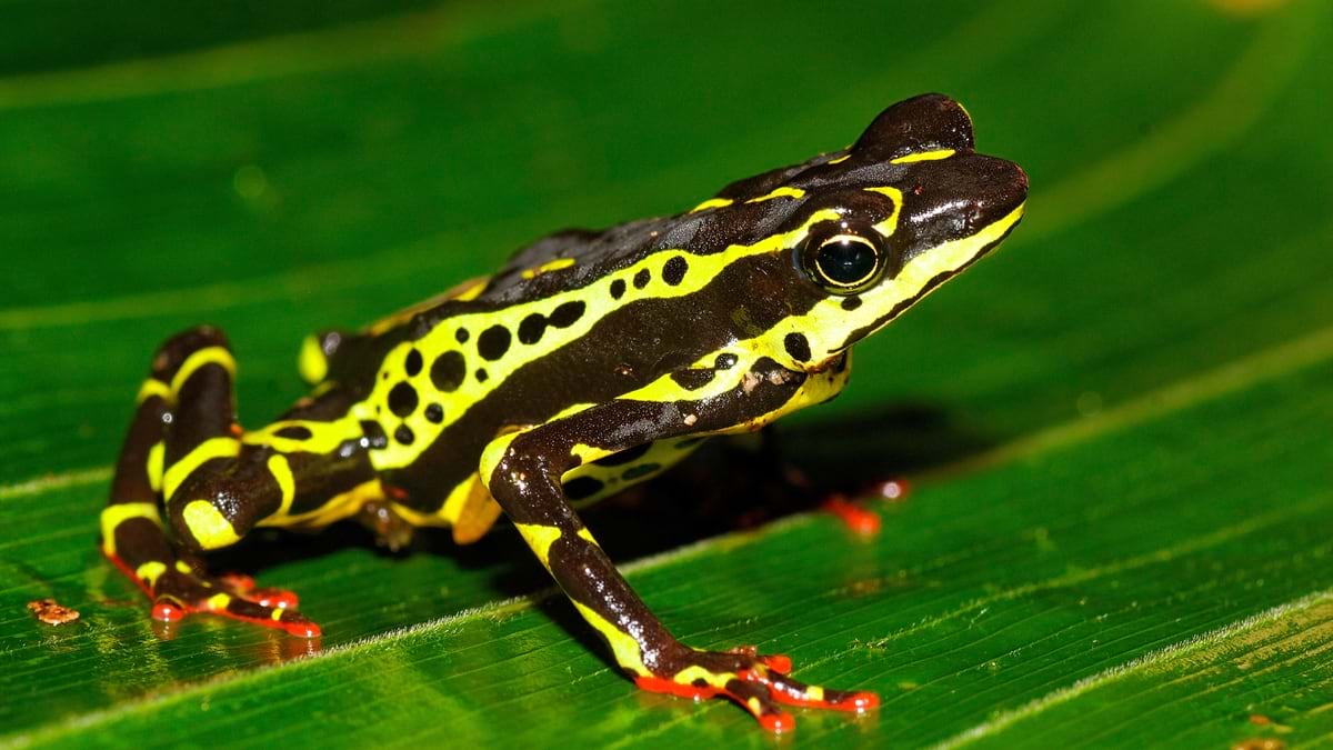
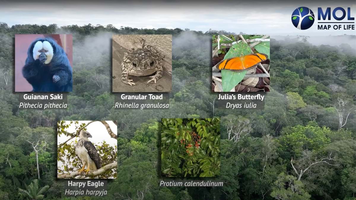
Last December, following five years of competition including a semifinals in Singapore and the finals in Brazil, the MOLRA team was named the runner-up winner of the XPRIZE Rainforest competition. After completing a 24-hour data collection sprint using its sensor-laden drones, the team identified 225 species, including four globally threatened species, in a square kilometer patch of rainforest in Brazil. For these species, the mostly autonomously operated sensors delivered a remarkable 5,000 spatially explicit occurrence records, going beyond a simple species list to supporting detailed species mapping.
“In partnership with Indigenous peoples and local communities, these tools are ideally suited for implementation to monitor, manage, and protect tropical rainforests globally,” said Peter Houlihan, former executive vice president of biodiversity and conservation at XPRIZE.
In the entrepreneurial spirit of the XPRIZE, and with support from Yale Ventures, the Yale team is putting the $2 million award toward expanding the project’s work as part of a spin-off company, Map of Life Solutions. The university spin-off will cater not only to governments and NGOs trying to implement conservation strategies, but also to companies seeking to reduce their local and global impacts.
![]()
Bourhan Yassin
President and CEO of Map of Life Solutions
“As pressures on lands are increasing and climate change accelerates, it is ever more important that we are guided by evidence and quantitative metrics to achieve positive outcomes for biodiversity,” Jetz said. “And it is critical that we ensure this data reaches the desks of decision-makers and is informed by their needs. This is why we are so excited about Map of Life Solutions offering the full link from new data collection technologies to the custom reporting that organizations require.”
Applying Technology to Species Identification
The drone-supported biodiversity sensing system, called MOLRA, is the newest and most localized addition to a larger public project more than a decade in the making. Jetz describes it as “an authoritative global evidence base and information platform around species distributions and their change at the global scale.” The Map of Life platform‘s origin dates back to Jetz’s PhD work in the late 1990s, which centered on building the first continental richness map of a large species group, the birds of Africa.
To truly understand species distributions, however, Jetz and his collaborators realized the map would need to expand to a global scale. In 2012, Jetz and his colleagues released the first public version of the map with initial support from the National Science Foundation and then the National Aeronautics and Space Administration (NASA). Other global data efforts sought to capture pieces of the picture, but no one had put it all together like this. It eventually grew into an ongoing project at Yale, motivated by the realization, Jetz said, “that there was no other structure out there that would bring something like Map of Life about.”
-
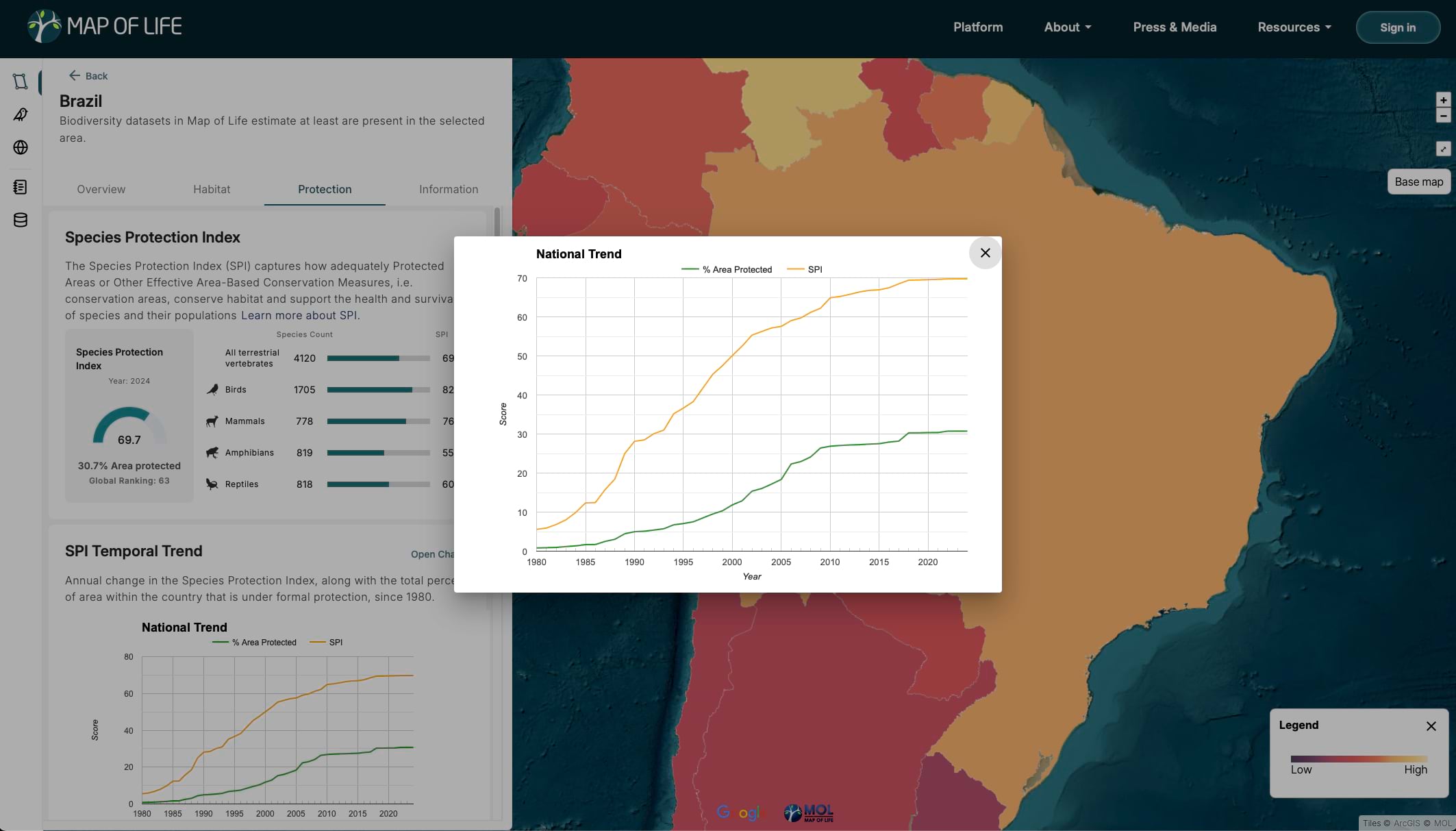
The Map of Life country overview for Brazil shows species counts, the level of protection, and related gaps in knowledge.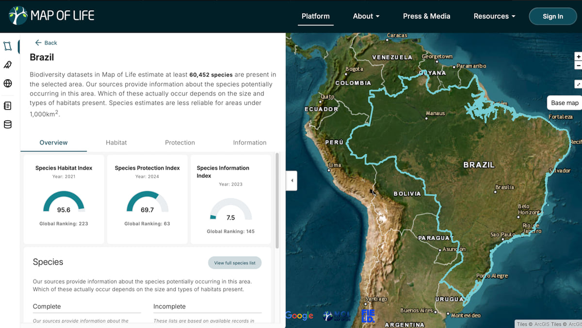
The advent over the past 15 years of cloud computing, commercial satellites, and affordable consumer drones would help make their vision a reality, allowing for more detailed, higher-resolution data and better predictions about where plants and animals might be. The map has grown to encompass over 450,000 species, thanks to data collected by thousands of researchers and citizen scientists across the globe. Its data has proved increasingly valuable to nonprofits and governments, which use it to measure compliance with global frameworks and progress toward local conservation goals.
The Map of Life’s key indicators—the Species Habitat Index (SHI), the Species Protection Index (SPI), and the Species Information Index (SII)—have been adopted globally to track conservation progress under the UN Global Biodiversity Framework. The SPI is the only metric of its kind that directly and quantitatively addresses progress for individual species under the UN’s 30×30 target, which stipulates more protected areas and similar measures to support biodiversity. The indicator and associated priority maps underpin the Half-Earth Project Map, the E.O. Wilson Biodiversity Foundation’s north star for measuring global progress in place-based species conservation.
Filling in Data Gaps with Drones
As the project has expanded in scale and scope, the Map of Life team has been thinking more carefully about data collection. The map already incorporates data from a range of digital technologies, including mobile field apps like ArcGIS Survey123, GPS trackers, stationary acoustic sensors, camera traps, drones, and satellites. It also includes data from local and national surveys, as well as the Global Biodiversity Information Facility (GBIF), which provides a large global repository of species occurrence data.
Through the Map of Life dashboard, researchers can use all the data to track species and habitat trends over time. In addition to supporting local conservation efforts, the data can help researchers find undiscovered species, better understand the impacts of extreme weather, and predict the spread of disease and pandemics.
“We can leverage information from one species to better understand others we know less about,” said Alex Killion, a conservation scientist and the managing director of Map of Life and the Center for Biodiversity and Global Change at Yale University. By looking at gaps on the map, he said, “We can pinpoint areas where if we had collected data like the presence or absence of a particular species, we’d then be able to better understand not only the distribution of that species but also related species.”
-
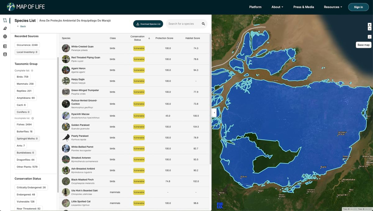
Various protected areas have been designated across the rainforests in the Amazon basin.
With more and better data, the map’s resolution increases, exposing more detail about the biodiversity in specific places, which makes it easier to know where and how to advance local conservation efforts. But getting that data isn’t easy.
“Biodiversity monitoring at the species level is expensive and time-consuming, especially in remote areas,” Killion said.
Map of Life Rapid Assessments are the Center’s effort to streamline and standardize biodiversity data collection through a portable kit of drones and sensors, designed for easy use by partners ranging from conservation NGOs to government agencies. “Using existing Map of Life data, we can more efficiently deploy these technologies to prioritize valuable species detections,” Killion said.
A drone flying autonomously over the tree canopy gathers imagery from which AI models can detect tree crowns, flowering canopies, and other vegetation characteristics to estimate crown diameters and heights and support habitat classifications. Audio samples help target birds, amphibians, and bats. Other sensors collect eDNA samples from air, water, and leaves, taking advantage of an emerging technology that can help fill in the gaps left by the other sensors.
“Basically from liftoff, it goes out, collects all of the imagery or acoustic and eDNA data, and then it comes back and lands itself,” Killion said.
-
Members of the MOLRA team being transported to the finals testing site by XPRIZE staff. From left to right: Walter Jetz (Yale University), Alex Killion (Yale University), and Nigel Pitman (Field Museum). (Photo: Cat Kutz, XPRIZE)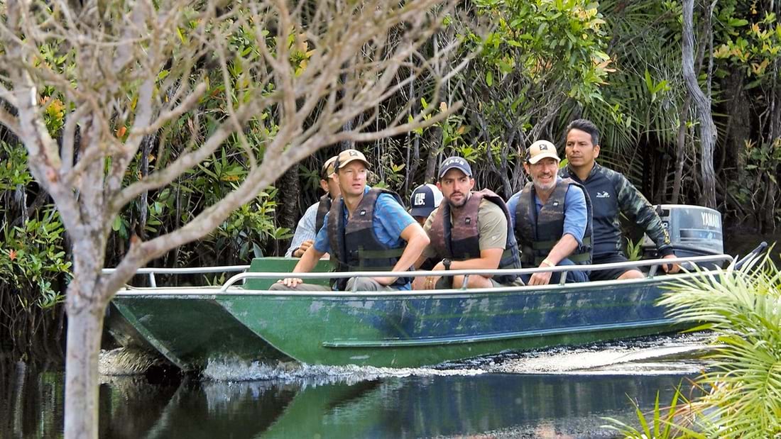
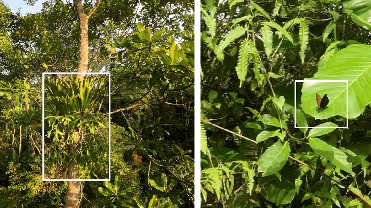
A smaller drone—an FPV, or first-person view drone—flies beneath the canopy and through the trees, capturing samples with the help of a remote team who watch real-time video through goggles and monitors. To make the system as scalable as possible, the team sought to develop it for users with no prior experience with drones.
“Even with those FPV drones, we taught Brazilian field technicians to operate them in 30 minutes, without speaking the same language,” Killion said.
Achieving Impressive Results Under the Crucible of Competition
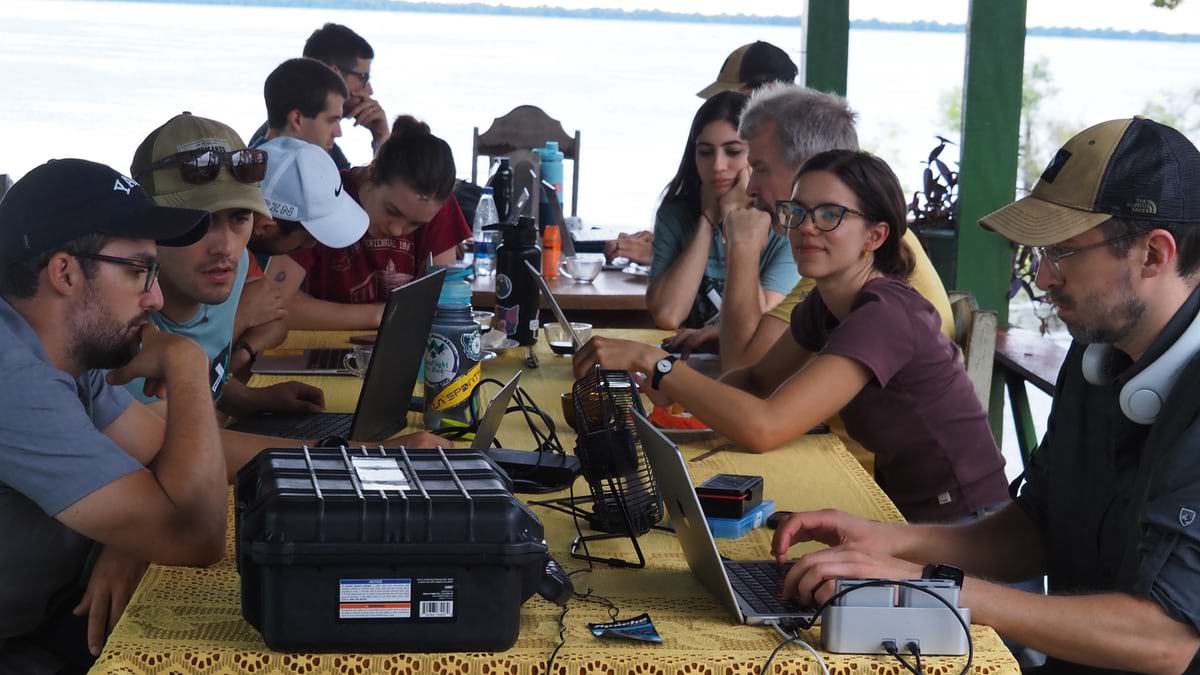
During the final competition, over a 24-hour period, the team operated four drones in the air simultaneously, with pit stops to switch out batteries and memory cards. The flights were scheduled for optimal data collection. For instance, they collected bird data at dawn and dusk, and mapped trees when there was full light.
Following the surveys, each XPRIZE team then had 48 hours to complete their assessments. Taxonomic experts helped review and confirm species identifications using a cloud-based platform, insights from Map of Life databases, consultation with global experts, and analysis by object identification AI models. With a newly streamlined process, the Map of Life Rapid Assessments team now says it can build high-resolution maps, indexes, and species lists of a site in as little as 24 hours.
Existing data and models proved to be useful to the team’s success by helping focus the drone surveys before they took flight. A predictive modeling engine helped estimate the terrestrial vertebrate and tree species that might be expected at a given site, helping researchers guide the design of sampling sensors and methods and informing the use of machine learning algorithms used for detection and analysis.
“We already came in with pretty good predictions of what species are likely to be found there based on Map of Life science and data,” Killion said. “That allows you to better plan data collection activities to capture the species you are interested in. For example, is eDNA an approach that is relevant for the species that you expect to occur there, based on the available DNA reference libraries?”
Local expertise also played a pivotal role in the team’s success, not only helping focus its efforts but ensuring accurate species identification, Killion said. For instance, while he piloted an FPV through the forest, a local researcher helped direct him to capture the most salient parts of a tree, which he otherwise wouldn’t have noticed.
“Not knowing the species as well as the local experts, we would be taking random photos, and they knew the exact part of the plant to capture to identify it from a different subspecies,” he said. “A pilot without taxonomic expertise may be taking photos of the same plant over and over again. Local experts know where to look, which underlies the importance of having drones that are easy to operate.”
Expert Humans Improve AI Results
During analysis, the team found that the AI could not identify as many species as local human reviewers. “What we found in the semi-finals, testing, and through the finals, is that even with advanced AI, you still needed experts to validate the identifications,” Killion said.
Much of the problem comes down to gaps in the training data. “Especially in remote areas like the Amazon, the data libraries to train those models are still sparse,” he said. “What you need are local experts who have an immense amount of knowledge about these species to do the identification.”
That lesson helped the team refine the design of the Map of Life Rapid Assessments dashboard interface. Instead of having local experts click through thousands of images and audio files, the system serves up the most unique samples. Improving links to the Map of Life taxonomy on the back end has made it easier to input and manage data.
“The aspect of AI that I was most excited about was about enabling those local experts,” Killion said. “Especially with local Indigenous peoples, this idea of a human in the loop or human-assisted AI is really important, and especially needed in this space.”
The team plans more experiments in Peru later this year to further develop its methods and to systematically compare their drone-enabled approach with more standard survey methods. “Can this rapid approach capture the same things? Or what are you missing? What is different with these technologies?”
In addition to local and national NGOs and governments, Killion said the new Map of Life Solutions spin-off company could perform surveys for a range of industries.
“Multinational corporations who have large land use impacts or holdings, big agricultural companies, real estate companies, project developers, have an interest in understanding the risks and the impacts of their activities on biodiversity,” he said. “And so that’s a huge sector that would benefit from assessments conducted in an efficient yet scientifically robust manner.”
This dual model will allow for the entirety of the Map of Life project to scale up even faster. “For those in academia, these aren’t the clients we are used to serving,” he said. And “as an academic institution, it’s hard to grow our ability to meet more client needs or go out and collect data on the ground, at least at the scale that we would want to advance the science, and to advance conservation decision-making.”
The startup is part of a stable of university-affiliated companies facilitated by Yale Ventures, where firms have typically come from university labs focused on engineering or medicine. But with growing pressure to address the biodiversity crisis—and with an ongoing reallocation of government spending around the environment—trends are shifting.
“The startup space is very much exploding now in the environmental sciences,” Killion said. “And we feel the academic community has an important role to play, to ensure that biodiversity monitoring and reporting are being done in a robust, scientific way.”
Learn more about how conservation groups and scientists team up to protect biodiversity with GIS.
Dawn Wright is Chief Scientist of Esri. She works to strengthen the scientific foundation for the company’s products and services. Notably, Dawn led the team that created the Ecological Marine Units (EMUs), a 3D digital ocean that creates better understanding of marine environments and how to plan for more sustainable activities there in the wake of climate change. Dawn joined Esri in 2011, and has written and contributed to some of the most definitive literature on marine geographic information system (GIS) technology. An elected member of both the National Academy of Sciences and the National Academy of Engineering, as well as the American Academy of Arts & Sciences, she earned her doctorate in Physical Geography and Marine Geology from UC Santa Barbara. In 2022, Dawn became the first Black person to visit the Challenger Deep in the Pacific Ocean, the deepest and most unexplored place on planet Earth.