.png)

According to United State Geological Survey (USGS)1, a Mw7.7 earthquake, referred to as “the Myanmar earthquake”, ruptured the central and southern Sagaing fault at 06:20:52.709 UTC on March 28, 2025, affecting Sagaing, Mandalay, and Nay Pyi Taw cities (Fig. 1). The mainshock originated at 22.001°N, 95.925°E, with a focal depth of 10.0 km. Eleven minutes later, a Mw 6.7 aftershock struck approximately 32 km to the south at 21.698°N, 95.969°E, also at a focal depth of 10 km. The most severely impacted areas extended from Singu City in the north to Pyu City in the south, with the maximum intensity reaching IX (MMI), primarily concentrated along the Sagaing fault and its adjacent regions2. As of April 8, 2025, according to incomplete statistics reported by the AHA Center, the earthquake resulted in 3645 fatalities, 148 missing persons, and 4817 injuries across Myanmar3. Given the significant human and economic toll, the Myanmar earthquake has garnered widespread attention from both public and scientific communities. It also raises a critical scientific question for seismologists: despite the ongoing global challenge of earthquake prediction, can specific technical approaches be employed to identify segments along active faults that are prone to high-magnitude earthquakes? What seismo-geological signatures does the Myanmar earthquake exhibit along the Sagaing fault, and how might these signatures be utilized to scientifically predict the likely location of a great earthquake prior to its occurrence? Addressing these questions could significantly enhance emergency preparedness and reduce the risks with large-scale earthquake disasters.
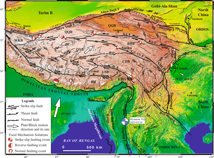
The blue-and-white beach ball denotes the Myanmar earthquake epicenter and its focal mechanism solution. KLF Kunlun fault, GZ-YSF Ganzi-Yushu fault, XSHF Xianshuihe fault, JLF Jiali fault, YTF Yarlung Tsangpo fault, HB Himalayan block, LSB Lhasa block, QTB Qiangtang block, CDB Chuan-Dian block, BHB Bayan Har block, QQB Qaidam-Qilian block, WKB West Kunlun block, ICB Indochina block, EHS eastern Himalayan syntaxis, HX Hexi Corridor.
This study presents a concise overview of the unique seismotectonic setting of the Myanmar earthquake. Utilizing the pixel offset tracking (POT) technique and interpretation of high-resolution optical satellite imagery, supplemented by limited records from several strong-motion stations, we accurately determine the length of the earthquake surface rupture zone, its rupturing segmentation and kinematic parameters. The analysis focuses on rupture dynamics, near-fault strong motion parameters, and associated disaster features. Furthermore, the potential predictability of the surface rupture locations is critically evaluated. The findings not only provide invaluable first-hand data and case-based insights for intermediate- to long-term monitoring, forecasting and hazard mitigation of great strike-slip earthquakes, but also contribute to a deeper understanding of their seismogenic mechanisms and disaster formation processes. These results offer a robust scientific basis for developing effective disaster prevention, mitigation, and emergency response strategies.
Tectonic setting
The nearly N25°E-directed frontal collision between the Indian and Eurasian plates, combined with the northward indentation of the Indian plate along the low-angle Himalayan Frontal Thrust (HFT), has shaped the Cenozoic Himalayan orogeny, including the eastern Himalayan syntaxis (EHS) and western Himalayan syntaxis, as well as the Tibetan Plateau (Fig. 1)4,5,6,7,8,9,10,11. This region thus constitutes a critical segment of the Alpine-Himalayan seismic belt12,13,14,15, which has experienced several major earthquakes in the 21st century, including the 2015 Mw 7.8 Gorkha earthquake in Nepal and the 2025 Mw 7.1 Dingri earthquake in southern Tibet (Fig. 1)16,17. To the south of the EHS, the oblique-slip collision zone between the Indian and Eurasian plates forms the northern part of the Sumatra-Java megathrust and marks the eastern terminus of the Alpine-Himalayan seismic belt. This oblique convergence has induced slip partitioning (Fig. 2), resulting in the formation of the eastward Andaman megathrust in the west, the right-lateral Sagaing fault in central Myanmar, and the Indo-Burman Ranges in between, where a series of reverse faults and folds have developed, indicating E-W crustal shortening and uplifting (Figs. 1, 2)18. The Andaman megathrust lies offshore western Myanmar19,20. Following the 2004 Mw 9.2 Sumatra-Andaman earthquake, GPS observations suggest a right-lateral strike-slip rate of approximately 36 mm/yr between the Indian and Sunda plates, with E-W crustal shortening across the Indo-Burman Ranges and Myanmar Central Basin at a rate of 7–9 mm/yr21. This region is capable of hosting great earthquakes21, as evidenced by the 1762 Great Arakan earthquake along the Andaman megathrust, which caused 3–7 m of uplift on Ramree and Cheduba Islands22,23,24.
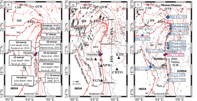
a Major active faults and right-lateral slip rates along the Sagaing fault (faults from Tapponnier, et al.55; Maurin, et al.25, Xu, et al.57). b GPS velocity field (South China block reference frame; data from Wang and Shen10, Zhang, et al.11). Black triangles: strong-motion stations. NSF: North Sagaing fault; SSF: South Sagaing fault. c Seismicity25. Gray dots: Engdahl and Villaseñor58 and USGS catalog hypocenters. Blue diamonds: Epicenters of M≧ 7 historical earthquakes (ISC catalog). Red diamond: 2025 Mw 7.7 epicenter. IBR Indo-Burma Ranges, MCB Myanmar Central Basin, SHL Shillong Plateau, HFT Himalayan Frontal Thrust.
The Sagaing fault, trending nearly N-S, extends 1200 km from the Putao Basin in the north, where it connects with the Jiali fault, to the Andaman Sea in the south (Fig. 2), serves as the eastern boundary fault of the Himalayan collision zone and has exhibited prominent right-lateral strike-slip motion during the late Quaternary, with geological and GPS-derived slip rates of 18–20 mm/yr (Fig. 2a, b). Near the EHS, the fault splays into multiple arcuate branches10,20,21,25,26,27,28. The onshore portion of the Sagaing fault can be divided at 23.4°N latitude into the north Sagaing fault (NSF), characterized by multiple branching structures, and the south Sagaing fault (SSF), which exhibits a relatively simple geometry (Fig. 2b). The SSF is a highly seismogenic structure (Fig. 2c), having generated 10 Mw≧7.0 earthquakes since 1900 AD, including the 1946 Mw7.8 Tagaung earthquake26,29. The 28 March 2025 Myanmar earthquake ruptured an earthquake gap characterized by low background seismicity, fulfilling multiple seismo-geologic signatures indicative of potential high-magnitude earthquake occurrence. A detailed investigation of this event holds significant academic and practical value for improving seismic hazard assessment and mitigation strategies.
Features of earthquake surface rupture zone
Based on the focal mechanism solutions, the spatial distributions of the mainshock and aftershocks reported by CENC and USGS, surface rupture interpretations derived from optical satellite imagery, and field observations, it is evident that the 2025 Myanmar earthquake ruptured the SSF, an arc-shaped right-lateral strike-slip fault trending NS in the north to NWN (N350°W) in the south (Fig. 3). The dynamic Rupture Process Inversion conducted by the Earthquake Mechanics and Seismology Lab (STMKG-BMKG) indicates that the rupture initiated in the northern part of the SSF near Sagaing City and initially propagated bilaterally during the first 25 s. Subsequently, the rupture transitioned to a predominantly unilateral southward propagation along the SSF with a total rupture duration of approximately 120 s. By integrating the aftershock distribution and Modified Mercalli Intensity (MMI) data, the estimated rupture length is inferred to be approximately 500 km1.
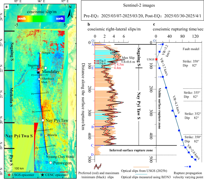
a Surface fault-parallel slip field derived from pre- and post-earthquake Sentinel-2 satellite imagery (24 scenes in total) using POT. The black continuous coarse line indicates the surface fault trace extracted from slip field, with short fine lines perpendicular to it locating the slip profiles presented in Fig. 4. The color gradient from red to blue indicates slips where blue points moved north and red points south. Short coarse lines on the left represent the segmented boundaries of the SSF29. Two red circles demote the positions of Figs. 5, 6. b Slip distribution along the SSF measured using POT and high-resolution optical imagery, demonstrating rupture segmentation into the Sagaing segment and Nay Pyi Taw segment. Light brown lines represent slip data sourced from USGS (USGS)2, while light blue lines obtained using BJ3N3 optical images. c Relationship between the rupturing distance and time based on the USGS four-segment finite-fault slip distribution model (USGS)32,59. A change in rupture propagation velocity is indicated by the blue arrow.
Multiple institutions, including National Taiwan University and NASA/JPL/Caltech/Copernicus, have utilized the POT30,31 to analyze pre- and post-earthquake Sentinel-1/2 imagery, delineating a discontinuous surface rupture zone extending ~460 km between Penwegon (18.239°N) and Singu (~22.627°N)32. Our analysis of 24 Sentinel-2 scenes (pre-earthquake: March 7–20, 2025; post-earthquake: March 30–April 1, 2025) reveals a primary right-lateral strike-slip faulting along the SSF, spanning 440 km (Fig. 3a, b), with a maximum horizontal coseismic slip of 5.8 ± 0.6 m near the USGS-reported epicenter between Sagaing City and Yaekhar Kan Reservoir (Figs. 3b, 4 P1-P1’). The along-strike slip distribution further subdivides the rupture zone into two distinct segments: the Sagaing S and the Nay Pyi Taw S (Fig. 3b). The Sagaing S segment exhibits peak coseismic slips of 5.8 ± 0.6 m near the center of the segment, with a gradual decrease observed toward both the northern and southern termini (A–E in Fig. 3b), indicating the occurrence of the first independent secondary rupturing event during the Myanmar earthquake. In contrast, the Nay Pyi Taw S segment is characterized by a slight eastward deflection in its strike orientation and a relatively uniform slip distribution of approximately 3.5 m with minimal along-strike variation (E–C in Fig. 3b; P3–P3’ to P6–P6’ profiles in Fig. 4), suggesting a dynamically distinct second secondary rupturing event. Notably, the coseismic slips observed at the boundary between these two segments are the smallest along the entire rupture zone, with a maximum value not exceeding 2.2 m and an average of approximately 2 m (E in Fig. 3b, P2–P2’ in Fig. 4). This low slip portion may serve as a boundary between the Sagaing S and the Nay Pyi Taw S. To validate these findings, we conducted field-based measurements at two sites (Red dots in Fig. 3a, b): an offset ridge south of Yaekhar Kan Reservoir and the ruptured and offset Mandalay-Shwebo Highway. The measured right-lateral slips of about 4.4 m and 4.5 m (Figs. 5, 6), respectively, align closely with the results obtained using the POT (Fig. 3b). Additional validation using BJ3N3 high-resolution (0.3 m) imagery near Sagaing City (~80 km coverage) and south of Nay Pyi Taw City (~30 km coverage), corroborates the USGS-derived slip measurements and Geospatial Information Authority of Japan (ALOS-2) data, providing robust constraints for rupture behavior analysis and disaster assessment.
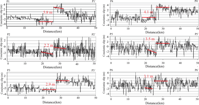
Their corresponding positions are located in Fig. 3a.
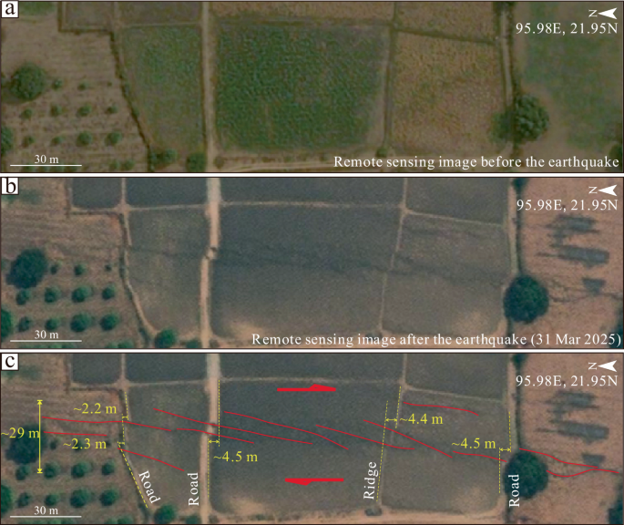
a Pre-earthquake imagery; b Post-earthquake imagery; c Distributions of the earthquake surface ruptures and measured coseismic slips.
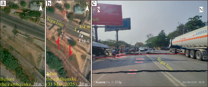
a Pre-earthquake imagery; b Post-earthquake imagery; c Photograph of the Mandalay-Shwebo Highway (Source: Twitter account @heungburma).
High-resolution optical imagery (GF-1B, BJ3N3, WorldView) confirms that the earthquake surface ruptures are localized along the SSF, extending from Yingu Township (22.539°N, A in Fig. 3) to Mawla Township (19.394°N, B in Fig. 3) over ~350 km. The surface rupture zone primarily consists of N0°–15°E trending shear and tensional shear fractures (Fig. 5), N45°E trending transtensional fractures (Figs. 6, 7), and tensile/compressive features in steps or stepovers, and they are arranged in an en echelon pattern to form a narrow (≦30 m width) and structurally simple rupture zone (Fig. 5). However, the existence of imagery gaps between Mawla Township (19.394°N) and Nyaung Chay Htauk Township (18.6°N) limits direct observation capabilities, thus impeding the precise delineation of the rupture zone’s extent. Integrating Sentinel-1 InSAR32 and POT result suggests a potential rupture extension to Nyaung Chay Htauk Township (18.60°N), yielding a total length of ~440 km (A–C in Fig. 3). The inclusion of USGS-reported 1-meter deformation sites extends the rupture length to 490 km (O–D in Fig. 3b), resulting in an average rupture length of 465 ± 25 km. This length exceeds previously documented strike-slip ruptures, such as the 2001 Mw 7.8 Kokoxili earthquake (426 km)33,34, the 2002 Mw 7.9 Denali earthquake (~340 km)35, and the 2023 Mw 7.8 Pazarcık earthquake (~300 km)36. Consequently, the 2025 Myanmar earthquake is identified as the continental strike-slip earthquake with the longest surface rupture zone globally.
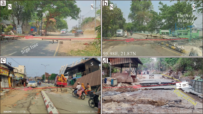
Field photographs of the coseismic slips of the earthquake surface rupture zone along the SSF (Source: Twitter account @heungburma). a–d represent coseismic slips measured from offset roads at four different sites.
Cascading rupture behavior
Previous studies have demonstrated that the SSF can be divided into Sagaing, Meiktila, Nay Pyi Taw, Pyu, and Bago segments (Figs. 3a, 8) in terms of historical earthquake ruptures, fault geometry, and fault branching features29. Under this segmentation framework, the 2025 Myanmar earthquake, which nucleated at the southernmost portion of the Sagaing segment, propagated through the Sagaing, Meiktila, Nay Pyi Taw, and Pyu segments, regardless of whether these segments were previously classified as earthquake gaps or had experienced historical ruptures since 1839 AD (Fig. 8). Consequently, the Myanmar earthquake is best characterized as an event resulting from a multi-segment, bead-like cascading rupture.
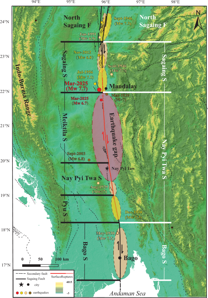
Yellow dots indicate the relocated epicenters of historical earthquakes50. Colored dashed ellipses delineate the fault segments that have undergone historical rupture. The segment boundaries proposed by Wang et al. (2014) are represented by horizontal black lines, while the revised segment boundaries inferred from the surface ruptures of the 2025 Myanmar earthquake are illustrated by horizontal white lines.
However, based on the spatial distribution of the coseismic slips along the SSF, the earthquake surface rupture zone can only be divided into the Sagaing S and the Nay Pyi Taw S. Specifically, the Sagaing S extends approximately 110 km from Mandalay International Airport (E) to Singu (A) with an average slip of 4.5 m, and the Nay Pyi Taw S spans a distance of approximately 330–380 km between Mandalay International Airport and Nyaung Chay Htauk, with an average coseismic slip of about 3.5 m (Fig. 3b). Although no significant surface rupture gap or abrupt slip reduction is evident at the boundary between the Sagaing S and Nay Pyi Taw S, this apparent continuity may be attributed to the structural transition between the Sagaing S and the Nay Pyi Taw S as well as the overlapping influence of the Mw 6.7 aftershock. Currently, it remains challenging to distinguish the coseismic rupture features and slip contributions associated with this strong aftershock due to its complex interaction with the mainshock rupture process.
Notably, the segmentation analysis of the Myanmar earthquake surface rupture zone reveals distinct variations in fault strike orientation. The Sagaing S predominantly exhibits a north-south orientation with a relatively linear fault trace, whereas the Nay Pyi Taw S initially follows a near north-south trend near Mandalay International Airport before gradually curving slightly eastward toward the south. The most pronounced eastward deflection occurs at 20.544°N latitude (Fig. 8). Further south, the fault strike transitions to N350°W, resulting in a deflection angle of approximately 10° relative to the Sagaing S in the north or the Bago S in the south, where no surface rupture was identified. This suggests that the Nay Pyi Taw S is predominantly characterized by right-lateral strike-slip motion but also incorporates a minor compressive component.
The surface rupture segmentation analysis further indicates that the previously proposed fault segmentation model for the SSF by Wang et al.29 requires reevaluation and potential revision. Specifically, the earthquake surface rupture zone along the SSF can be reclassified into two principal segments: the Sagaing S and the Nay Pyi Taw S (Fig. 3b). The Sagaing S is dominated by pure right-lateral strike-slip ruptures, while the Nay Pyi Taw S integrates the previously defined Meiktila, Nay Pyi Taw, and Pyu segments and is characterized by transpressive shear ruptures associated with higher frictional resistance. Consequently, the Myanmar earthquake initiated as a pure shear rupture within the Sagaing segment, which subsequently triggered compressive shear ruptures on the Nay Pyi Taw S. The abrupt change in strike between the Nay Pyi Taw S and Bago S likely represents the structural termination of the Myanmar earthquake rupture propagation (Fig. 8).
Supershear rupture propagation
A total of 34 teleseismic broadband P-waveforms, 44 broadband SH-waveforms, and 61 long-period surface waveforms were selected based on data quality and azimuthal distribution. Combined with a four-segment finite-fault model, USGS inversion results1 indicate that all segments of the SSF, except for the Bago S, were involved in the earthquake rupture process. This conclusion is further supported by the presence of coseismic surface ruptures observed on these segments (Fig. 8). The earthquake initiated at a focal depth of approximately 10 km in the southernmost portion of the Sagaing S, near Sagaing City. During the initial 25 s, the rupture propagated bilaterally northward and southward at varying velocities. The northward propagation proceeded at a velocity of 3.2 km/s along the segment previously ruptured during the 1956 Mw 7.1 earthquake, while the southward propagation reached a supershear velocity of approximately 3.7 km/s within the historic earthquake gap following 1839 AD, covering a rupture length of up to 75 km.
After 25 s, the rupture transitioned into unilateral propagation toward the south at supershear velocity. Within the subsequent 60 s, it traversed the historic earthquake gap and the sections that ruptured during the 1929 Mw ≤ 7earthquake and the 1930 Mw 7.2 earthquake, respectively, accumulating a total rupture length of up to 269 km at an average velocity of 4.3 km/s. Subsequently, the rupture velocity sharply decreased to 2.0 km/s and persisted for approximately 40 s, extending over a distance of about 80 km (Fig. 3c). This rupture process corresponds to an overall rupture zone length of approximately 500 km, with the majority of the rupture propagating at supershear velocities (Fig. 3c). Given that the surface rupture length was estimated to be approximately 465 ± 25 km, it is inferred that the southern termination of the rupture transitioned from supershear to sub-Rayleigh velocity north of Penwegon Township in Nyaung Chay Htauk.
The analysis presented above highlights notable differences in rupture propagation characteristics of the Myanmar earthquake compared to other seismic events, particularly the occurrence of supershear rupture only along localized portions of their seismogenic faults37,38,39,40. This rare phenomenon of long-distance supershear rupture propagation may be attributed to the remarkably simple and linear geometry of the Nay Pyi Taw S of the SSF between Mandalay International Airport and Nyaung Chay Htauk, where the NNW-trending fault is characterized by transpressive shear deformation36,38,41,42,43,44. Such structurally favorable fault geometry can lead to widespread strong ground shaking and extensive fault-related damage.
Near-fault strong ground motion and related disaster
Five strong-motion stations located within the epicentral region and its surrounding areas successfully recorded the strong ground motion generated by the Myanmar earthquake (Fig. 2b; Table 1). Among these, the NPW station is situated on the western side of the Sagaing fault, approximately 6 km from the fault trace. It recorded the highest acceleration amplitude, with peak values of 0.631 g in the N-S direction, 0.573 g in the E-W direction, and 1.066 g in the vertical direction. Notably, the vertical component exceeds the horizontal components in magnitude, and the platform section of the response spectrum is concentrated between 0.1 s and 1 s (Fig. 9a). In contrast, the NGU station, located 113.6 km away from the Sagaing fault, exhibits significantly lower acceleration amplitudes compared to the NPW station but higher than those recorded at more distant stations (NGU, KTN, CHTO, YGN). This observation suggests that as the distance from the fault increases, the spectral platform section shifts significantly, indicating a pronounced increase in long-period responses and rapid attenuation of short-period components (Fig. 9b).
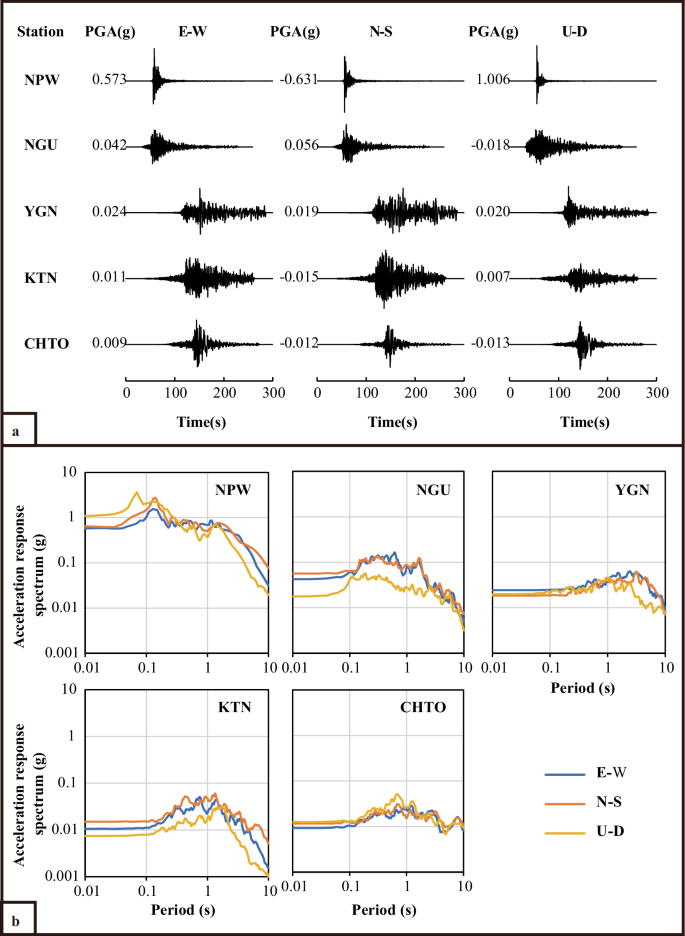
Strong-motion records from stations near the epicenter of the Myanmar earthquake and its surrounding regions. a Strong motion records; b Response spectra
Fourier transform analysis of the ground motion data reveals a clear trend: with increasing distance from the fault, overall amplitude decreases, high-frequency components attenuate rapidly, and low-frequency components become increasingly dominant (Fig. 10). Data from the NPW station indicate that near-fault ground motion contains abundant high-frequency components, primarily within the range of 1 Hz to 10 Hz, along with relatively rich medium-high frequency components between 0.5 Hz and 2 Hz, and a smaller proportion of low-frequency components between 0.1 Hz and 1 Hz (Fig. 10, NPW station). Remarkably, despite being located 372 km from the Sagaing fault, the KTN station still records relatively abundant medium-high frequency components, likely due to the hard soil conditions at the station site. Conversely, other stations (NGU, CHTO, YGN), located in regions characterized by soft soil deposits, exhibit potential amplification of long-period components (Fig. 10). These observed characteristics of near-fault strong ground motion are believed to be closely related to both shear and supershear rupture propagation mechanisms during the Myanmar earthquake. Furthermore, the spectral distribution of this ground motion exerts substantial destructive forces on low-rise buildings (1–3 stories) and a notable damage potential for mid-rise buildings (4–10 stories).
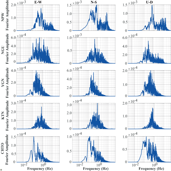
E-W east-west component; N-S north-south component; U-D vertical component
The Myanmar government’s “Myanmar National Building Code 2020”45 adopts an earthquake-resistant design methodology comparable to the American ASCE-7 code. The design basis corresponds to a 50-year return period with a 10% exceedance probability, equivalent to two-thirds of the maximum credible earthquake (MCE). Mandalay City, situated in close proximity to the potentially seismogenic Sagaing fault, is classified as a high seismic hazard zone. According to the MNBC 2020, the MCE-level ground motion parameters for this region are approximately SDS = 1.20 g at a 0.2-second period and S1 = 0.70 g at a 1.0-second period. This level of seismic hazard aligns with the design ground motion parameters specified for Zone IX in the Chinese seismic design code46. Additionally, most of Mandalay City is categorized as a Class C site, while a small portion in the west is classified as a Class D site. Site coefficients Fa and Fv for Class C and D sites are 1.0 and 1.3, and 1.02 and 1.5, respectively. Although the response spectra of the two codes exhibit similar shapes, the Chinese code demonstrates higher peak values in the high-frequency range, whereas the MNBC 2020 yields larger values in the long-period range.
In terms of structural seismic design, the MNBC 2020 largely references the American ACI 318-0847. Similar to the Chinese code GB 50011-2010, both codes specify minimum member dimensions, adequate reinforcement ratios, and confinement measures to ensure structural ductility. For example, field observations show that new building frame columns generally have cross-sectional dimensions around 400 mm, meeting current code requirements. However, older structures, particularly those constructed before the first edition of the Myanmar National Building Code was issued in 2012, typically feature column sections of approximately 200 mm. Such dimensions may result in insufficient load-bearing capacity for buildings exceeding three stories. Consequently, the presence of rich high-frequency and relatively abundant medium-high frequency components in near-fault ground motion explains why numerous historic buildings in Sagaing City and some mid-rise structures built prior to 2012 sustained severe damage.
According to statistics provided by the United Nations Satellite Center (UNOSAT), a total of 509 buildings were damaged in Mandalay Province. Among them, 150 ancient brick masonry temples and the Mandalay Royal Palace Wall, constructed in 1859, tilted or partially collapsed due to inadequate seismic retrofitting. The Ava Bridge, a simply supported beam bridge built in 1934 connecting Mandalay City to Sagaing City, completely collapsed during the earthquake, whereas three steel arch bridges constructed in 2008 across the Irrawaddy River remained largely intact. Mid-rise buildings that collapsed were predominantly those constructed before the release of the first generation of the Myanmar National Building Code in 2012, with typical frame column dimensions of about 200 mm. Moreover, critical joint zones in newly constructed buildings failed to meet the basic stirrup reinforcement requirements stipulated by MNBC 202045. These deficiencies were among the primary causes of the collapse of structures such as the Sky Villa high-end apartment complex (11 floors above ground) on 60th Street and the Golden City Hotel (8 floors above ground) at the intersection of 30th Street (east-west) and 70th Street (north-south) in Mandalay City.
Similar to most continental surface rupture earthquakes globally, the most intense seismic impacts occurred along the surface rupture zone and its immediate vicinity. These surface ruptures and associated coseismic offsets disrupted farmlands and embankments, and severely damaged or destroyed buildings and roads crossing the surface rupture zone. This highlights that fact that any surface structure intersecting active faults faces an unavoidable “anti-fracture” challenge during earthquake. Therefore, it is imperative to establish and enforce legal frameworks that prohibit the construction of surface structures on seismically active faults in China.
Discussion on predictability of M≧7.0 earthquake locations
In light of the significant losses and casualties caused by major earthquakes, a frequently raised question across all sectors of society is whether the location of the Myanmar earthquake on the Sagaing fault could have been accurately or relatively precisely predicted or identified prior to its occurrence. This issue is not only an urgent scientific challenge requiring resolution but also a fundamental prerequisite for effective emergency preparedness and efficient mitigation of earthquake disaster risks. The Sagaing fault, which trends nearly in a north-south direction, can be divided at 23.4°N latitude into the NSF and SSF (Fig. 2b). The 2025 Myanmar earthquake occurred where the strike of the SSF exhibits a minor eastward deflection from the North-South trending Sagaing S to the northwest-north trending Nay Pyi Taw S. The Sagaing S is predominantly characterized by right-lateral faulting, while the Nay Pyi Taw S is dominated by right-lateral faulting with a minor compressive component. Theoretically, the Nay Pyi Taw S represents a compressive shear zone between the north-south trending Sagaing S and the Bago S (Fig. 8). At least the ruptured segments satisfy the following five seismo-geological signatures for identifying potential location of a high-magnitude earthquake48:
-
1.
Active fault located within the tectonic boundaries of intracontinental active blocks or plates. The Sagaing fault accommodates the right-lateral strike-slip motion within the oblique collision zone between the Indian Plate and the Eurasian Plate south of the EHS (Figs. 1, 2). Due to a high right-lateral strike-slip rate of approximately 20 mm/yr, the Sagaing fault inherently possesses a higher seismic hazard risk compared to other intraplate active faults.
-
2.
Historical earthquake rupture gaps on active fault. Historical records indicate that numerous surface-rupturing earthquakes have occurred along the Sagaing fault (Figs. 2c, 7)26,27,29,45,49. The 2025 Myanmar earthquake surface rupture zone primarily followed two newly revised segments of the SSF: the Sagaing S and Nay Pyi Taw S. Among them, the central-northern portion of the Nay Pyi Taw S is a typical historical earthquake rupture gap (Fig. 8). It had remained dormant since occurrence of a magnitude Mw > 7 earthquake in March 1839 AD29,50. By the time of the 2025 earthquake, it had accumulated elastic strain energy equivalent to approximately 3.5 m of coseismic slip.
-
3.
Locked segments of active fault. Inversion results based on cross-fault GPS observation data reveal that the Sagaing fault near Mandalay is in a locked state, although the locking depth is only 10 km, while the locking depth to the north or south ranges from 16 km to 20 km25,49. Moreover, the initial rupture point of the 2025 Myanmar earthquake was located at a strain-concentrated site on the Sagaing fault south of the EHS, where the maximum shear strain rate reaches 109.4 × 10⁻⁹–226.2 × 10⁻⁹ yr−151.
-
4.
Fault segments with high or relatively high seismic wave velocity. Early studies using Matched-Filter Frequency-Time Analysis on long-period Rayleigh dispersion data recorded at the Chiang Mai (CHTO) and Shillong (SHIO) stations of the global digital seismic network (CDSN), as well as the Kunming (KMI) and Lhasa (LSA) stations of Chinese digital seismic network (CDSN) from 1978 to 2005, showed that the Sagaing fault lies on the relatively high-velocity side of the shear-wave velocity gradient, where the shear-wave velocity changes from 3.4 km/s to 3.1 km/s at a depth of approximately 20 km52. More recently, inversions of waveform data recorded by mobile arrays and fixed stations for the crustal shear-wave velocity structure of Central Myanmar have demonstrated that the Sagaing fault in Sagaing City and its adjacent areas is situated within a region with a high Vs velocity of approximately 3.0 km/s18,53,54, suggesting that the Sagaing fault is in a locked state with significant strain accumulation.
-
5.
Segments with a scarcity of small and moderate earthquakes. Based on the earthquake catalog provided by USGS for events with magnitudes M≧3 and depths≦40 km from 1908 to 2020, it is evident that the primary rupture segments of the 2025 Myanmar earthquake along the SSF exhibited exceptionally low seismicity (Fig. 2c)25,49. This observation indicates that these segments had transitioned into a locked state with minimal or no strain energy being released before the Myanmar earthquake.
As can be seen from the above, the segments of the SSF where the 2025 earthquake ruptured exhibit five seismo-geological signatures indicative of a high-magnitude earthquake risk on the active faults48. From an academic perspective, the spatial location of this Myanmar earthquake could potentially be predicted in advance.
Conclusions and recommendations
The Myanmar earthquake on March 28, 2025, ruptured the SSF and was a typical two-segments-ruptured cascading event. It featured an earthquake surface rupture zone extending 465 ± 25 km in length and a maximum right-lateral coseismic slip of up to 5.8 m. To date, this earthquake surface rupture zone represents the longest continental strike-slip faulting event, characterized primarily by resegmentation supershear rupture propagation. This propagation produced a distinct spatiotemporal distribution of strong ground motion spectra in the near-fault region. Specifically, the near-fault ground motion exhibits rich high-frequency components, predominantly ranging from 1 Hz to 10 Hz. Additionally, relatively abundant medium-high frequency components are observed in the range of 0.5 Hz to 2 Hz. In contrast, far-field ground motion is dominated by low-frequency components within the range of 0.1 Hz to 1 Hz. These characteristics are closely associated with the supershear rupture propagation during the Myanmar earthquake. Combined with the tearing effect of the surface ruptures during the earthquake, these near-fault strong ground motion spectra were the primary cause of severe damage to buildings and structures near the fault. Therefore, it is essential to enhance research into the mechanisms of cascading rupture earthquakes and supershear rupture propagation across multiple segments of active faults. Furthermore, quantitative analysis of the characteristics of strong ground motion spectra generated by supershear ruptures and their disaster-causing processes is necessary. Such efforts will deepen our understanding of the destructive power of cascading and supershear ruptures.
Furthermore, in-depth analysis has revealed that the SSF, where the Myanmar earthquake ruptured, exhibits five seismo-geologic signatures that can be used to identify potential high-magnitude earthquakes (M≧7.0). Based on these findings, it can be inferred that such earthquakes are, in principle, predictable in terms of their occurrence locations. Consequently, it is highly recommended to initiate dedicated investigation and research into seismo-geologic signatures associated with mega strike-slip faults in the Qinghai-Tibetan Plateau and its adjacent regions, as well as globally. This approach aims to effectively explore methods for monitoring and predicting great earthquakes.
Data availability
No datasets were generated or analysed during the current study.
References
USGS. M 7.7 - 2025 Mandalay, Burma (Myanmar) Earthquake: Finite Fault. https://earthquake.usgs.gov/earthquakes/eventpage/us7000pn9s/finite-fault (2025).
USGS. M 7.7 - 2025 Mandalay, Burma (Myanmar) Earthquake: PAGER. https://earthquake.usgs.gov/earthquakes/eventpage/us7000pn9s/pager (2025).
Lin, X. The severe earthquake in Myanmar has resulted in 3,645 fatalities in the country. https://www.thepaper.cn/newsDetail_forward_30597227 (2025).
Baker, D. M. et al. Development of the Himalayan frontal thrust zone: salt range, Pakistan. Geology 16, 3–7 (1988).
Bilham, R., Larson, K. & Freymueller, J. GPS measurements of present-day convergence across the Nepal Himalaya. Nature 386, 61–64 (1997).
Jiao, L., Tapponnier, P., Coudurier-Curveur Mccallum, A. & Xu, X. The shape of the Himalayan “Arc”: an ellipse pinned by syntaxial strike-slip fault tips. Proc. Natl. Acad. Sci. USA121, e2313278121 (2024).
Larson, K. M., Bürgmann, R., Bilham, R. & Freymueller, J. T. Kinematics of the India-Eurasia collision zone from GPS measurements. J. Geophys. Res.: Solid Earth 104, 1077–1093 (1999).
Lavé, J. & Avouac, J. P. Active folding of fluvial terraces across the Siwaliks Hills, Himalayas of central Nepal. J. Geophys. Res. Solid Earth 105, 5735–5770 (2000).
Lyon-Caen, H. & Molnar, P. Gravity anomalies, flexure of the Indian Plate, and the structure, support and evolution of the Himalaya and Ganga Basin. Tectonics 4, 513–538 (1985).
Wang, M. & Shen, Z.-K. Present-day crustal deformation of continental China derived from GPS and its tectonic implications. J. Geophys. Res. Solid Earth 125, e2019JB018774 (2020).
Zhang, P.-Z. et al. Continuous deformation of the Tibetan Plateau from global positioning system data. Geology 32, 809–812 (2004).
Ader, T. et al. Convergence rate across the Nepal Himalaya and interseismic coupling on the Main Himalayan Thrust: Implications for seismic hazard. J. Geophys. Res. Solid Earth 117, https://doi.org/10.1029/2011JB009071 (2012).
Bilham, R., Gaur, V. K. & Molnar, P. Himalayan seismic hazard. Science 293, 1442–1444 (2001).
Elliott, J. R., Walters, R. J. & Wright, T. J. The role of space-based observation in understanding and responding to active tectonics and earthquakes. Nat. Commun. 7, 13844 (2016).
Stevens, V. L. & Avouac, J. P. Interseismic coupling on the main Himalayan thrust. Geophys. Res. Lett. 42, 5828–5837 (2015).
Hubbard, J. et al. Structural segmentation controlled the 2015 Mw 7.8 Gorkha earthquake rupture in Nepal. Geology 44, 639–642 (2016).
Xu, X., Wang, S., Cheng, J. & Wu, X. Shaking the Tibetan Plateau: Insights from the Mw 7.1 Dingri earthquake and its implications for active fault mapping and disaster mitigation. npj Nat. Hazards 2, 16 (2025).
Bai, Y. et al. Seismic structure across central Myanmar from joint inversion of receiver functions and Rayleigh wave dispersion. Tectonophysics 818, 229068 (2021).
Kamesh Raju, K. A., Murty, G. P. S., Amarnath, D. & Kumar, M. L. M. The west Andaman fault and its influence on the aftershock pattern of the recent megathrust earthquakes in the Andaman-Sumatra region. Geophys. Res. Lett. 34, https://doi.org/10.1029/2006GL028730 (2007).
Nielsen, C., Chamot-Rooke, N. & Rangin, C. From partial to full strain partitioning along the Indo-Burmese hyper-oblique subduction. Mar. Geol. 209, 303–327 (2004).
Socquet, A. et al. India and Sunda plates motion and deformation along their boundary in Myanmar determined by GPS. J. Geophys. Res. Solid Earth 111, https://doi.org/10.1029/2005JB003877 (2006).
Cummins, P. R. The potential for giant tsunamigenic earthquakes in the northern Bay of Bengal. Nature 449, 75–78 (2007).
Halsted, E. P. Report on the island of Chedooba (Asiatic Society of Bengal, 1841).
Wang, Y. et al. Permanent upper plate deformation in western Myanmar during the great 1762 earthquake: Implications for neotectonic behavior of the northern Sunda megathrust. J. Geophys. Res. Solid Earth 118, 1277–1303 (2013).
Maurin, T., Masson, F., Rangin, C., Min, U. T. & Collard, P. First global positioning system results in northern Myanmar: constant and localized slip rate along the Sagaing fault. Geology 38, 591–594 (2010).
Thein, M., Myint, T., Tun, S. T. & Swe, T. L. Earthquake and tsunami hazard in Myanmar. J. Earthq. Tsunami 03, 43–57 (2009).
Wang, Y. et al. Earthquakes and slip rate of the southern Sagaing fault: insights from an offset ancient fort wall, lower Burma (Myanmar). Geophys. J. Int. 185, 49–64 (2011).
Wang, Y. et al. GPS-constrained inversion of present-day slip rates along major faults of the Sichuan-Yunnan region, China. Sci. China Ser. D Earth Sci. 51, 1267–1283 (2008).
Wang, Y., Sieh, K., Tun, S. T., Lai, K.-Y. & Myint, T. Active tectonics and earthquake potential of the Myanmar region. J. Geophys. Res. Solid Earth 119, 3767–3822 (2014).
Aati, S., Milliner, C. & Avouac, J.-P. A new approach for 2-D and 3-D precise measurements of ground deformation from optimized registration and correlation of optical images and ICA-based filtering of image geometry artifacts. Remote Sens. Environ. 277, 113038 (2022).
Ayoub, F., Leprince, S. & Avouac, J.-P. Co-registration and correlation of aerial photographs for ground deformation measurements. ISPRS J. Photogramm. Remote Sens. 64, 551–560 (2009).
Bradley K. & Hubbard J. Surface ruptures of the Myanmar M7.7 earthquake mapped from space. Earthquake Insights, https://doi.org/10.62481/51b7df8c (2025).
Xu, X., Chen, W., Ma, W., Yu, G. & Chen, G. Surface Rupture of the Kunlunshan Earthquake (Ms 8.1), Northern Tibetan Plateau, China. Seismol. Res. Lett. 73, 884–892 (2002).
Xu, X., Yu, G., Klinger, Y., Tapponnier, P. & Van Der Woerd, J. Reevaluation of surface rupture parameters and faulting segmentation of the 2001 Kunlunshan earthquake (Mw7.8), northern Tibetan Plateau, China. J. Geophys. Res. Solid Earth 111, https://doi.org/10.1029/2004JB003488 (2006).
Eberhart-Phillips, D. et al. The 2002 Denali Fault Earthquake, Alaska: a large magnitude, slip-partitioned event. Science 300, 1113–1118 (2003).
Ren, C. et al. Supershear triggering and cascading fault ruptures of the 2023 Kahramanmaraş, Türkiye, earthquake doublet. Science 383, 305–311 (2024).
Bouchon, M. & Vallée, M. Observation of long supershear rupture during the magnitude 8.1 Kunlunshan earthquake. Science 301, 824–826 (2003).
Jia, Z. et al. The complex dynamics of the 2023 Kahramanmara, Turkey M 7.8-7.7 earthquake doublet. Science 381, 985–990 (2023).
Vallée, M., Landès, M., Shapiro, N. M. & Klinger, Y. The 14 November 2001 Kokoxili (Tibet) earthquake: high-frequency seismic radiation originating from the transitions between sub-Rayleigh and supershear rupture velocity regimes. J. Geophys. Res. Solid Earth 113, https://doi.org/10.1029/2007JB005520 (2008).
Wen, Y.-Y., Ma, K.-F., Song, T.-R. A. & Mooney, W. D. Validation of the rupture properties of the 2001 Kunlun, China (Ms = 8.1), earthquake from seismological and geological observations. Geophys. J. Int. 177, 555–570 (2009).
Bruhat, L., Fang, Z. & Dunham, E. M. Rupture complexity and the supershear transition on rough faults. J. Geophys. Res. Solid Earth 121, 210–224 (2016).
Rousseau, C.-E. & Rosakis, A. J. Dynamic path selection along branched faults: Experiments involving sub-Rayleigh and supershear ruptures. J. Geophys. Res. Solid Earth 114, https://doi.org/10.1029/2008JB006173 (2009).
Tang, R., Yuan, J. & Gan, L. Free-surface-induced supershear transition in 3-D simulations of spontaneous dynamic rupture on oblique faults. Geophys. Res. Lett. 48, e2020GL091621 (2021).
Zhang, Y. et al. Geometric controls on cascading rupture of the 2023 Kahramanmaraş earthquake doublet. Nat. Geosci. 16, 1054–1060 (2023).
MNBC 2016. Myanmar National Building Code, Part 3: Structural Design. Ministry of Construction Myanmar (2020).
GB 50011-2010. Code for Seismic Design of Buildings. China Ministry of Construction. (in Chinese) (2016).
ACI 318-08. Building code requirements for structural concrete and commentary. American Concrete Institute (2008).
Xu, X., Wu, X., Yu, G., Tan, X. & Li, K. Seismo-geological signatures for identifying M≥7.0 earthquake risk areas and their premilimary application in mainland China.Seismol. Geol 39, 219–275 (2017).
Tha Zin Htet, T. et al. Present-day crustal deformation and slip rate along the southern Sagaing fault in Myanmar by GNSS observation. J. Asian Earth Sci. 228, 105125 (2022).
Hurukawa, N. & Maung Maung, P. Two seismic gaps on the Sagaing Fault, Myanmar, derived from relocation of historical earthquakes since 1918. Geophys. Res. Lett. 38, https://doi.org/10.1029/2010GL046099 (2011).
Wei, S., Xu, X., Wu, Y., Liang, S. & Luo, J. The present-day strain characteristics and dynamic mechanism around the Eastern Himalayan Syntaxis revealed by the GPS data. Acta Geologica Sinca 98, 1114–1128 (2024).
Hu, J.-F. et al. Crust-mantle velocity structure of S wave and dynamic process beneath Burma arc and its adjacent regions. Chin. J. Geophys 51, 105–114 (2008).
Wang, X. et al. A 3-D shear wave velocity model for Myanmar region. J. Geophys. Res.: Solid Earth 124, 504–526 (2019).
Yao, J. et al. Imaging the upper 10 km crustal shear-wave velocity structure of central myanmar via a joint inversion of P-wave polarizations and receiver functions. Seismol. Res. Lett. 93, 1710–1720 (2022).
Tapponnier, P. et al. Oblique stepwise rise and growth of the Tibet plateau. Science 294, 1671–1677 (2001).
Xu, X. et al. Normal- and oblique-slip of the 2008 Yutian earthquake: evidence for eastward block motion, northern Tibetan Plateau. Tectonophysics 584, 152–165 (2013).
Xu, X. et al. Seismotectonic map in China and its adjacent regions (Seismogical Press, 2016).
Engdahl, E. R. & Villaseñor, A. in International Geophysics Vol. 81 (eds William H. K. Lee, Hiroo Kanamori, Paul C. Jennings, & Carl Kisslinger) 665-cp662 (Academic Press, 2002).
USGS. Remote Surface Rupture Observations for the M7.7 2025 Mandalay, Burma (Myanmar) Earthquake. https://experience.arcgis.com/experience/e40a6967c3ea42dd85bf44037e05482b (2025).
Acknowledgements
This research was supported by Key Technology Research Project of the Ministry of Science and Technology (2023XAGG0067) and the National Natural Science Foundation of China (41941016). Thanks for the BJ3N3 satellite image dataset shared by the China GEOSS Data Sharing Network.
Ethics declarations
Competing interests
The authors declare no competing interests.
Additional information
Publisher’s note Springer Nature remains neutral with regard to jurisdictional claims in published maps and institutional affiliations.
Rights and permissions
Open Access This article is licensed under a Creative Commons Attribution-NonCommercial-NoDerivatives 4.0 International License, which permits any non-commercial use, sharing, distribution and reproduction in any medium or format, as long as you give appropriate credit to the original author(s) and the source, provide a link to the Creative Commons licence, and indicate if you modified the licensed material. You do not have permission under this licence to share adapted material derived from this article or parts of it. The images or other third party material in this article are included in the article’s Creative Commons licence, unless indicated otherwise in a credit line to the material. If material is not included in the article’s Creative Commons licence and your intended use is not permitted by statutory regulation or exceeds the permitted use, you will need to obtain permission directly from the copyright holder. To view a copy of this licence, visit http://creativecommons.org/licenses/by-nc-nd/4.0/.
About this article
Cite this article
Xiwei, X., Wenjun, K., Tao, W. et al. The Mw7.7 Myanmar earthquake: a continental longest surface-rupturing supershear cascading event. npj Nat. Hazards 2, 73 (2025). https://doi.org/10.1038/s44304-025-00125-z
Received: 05 June 2025
Accepted: 10 July 2025
Published: 25 July 2025
DOI: https://doi.org/10.1038/s44304-025-00125-z