.png)

Abstract
The Rio Grande-Bravo basin shared by the United States and Mexico is experiencing a severe water crisis demanding urgent attention. In recent decades, water storage reservoirs, aquifers, and annual streamflow volumes have been substantially depleted, leaving little buffer for continued over-consumption of renewable water supplies. Despite the great scarcity of water and intensifying water shortages in this basin, a full accounting of the river’s consumptive uses and losses has never been undertaken. In this study we assemble detailed water consumption estimates from a broad array of sources to describe how surface and ground water were consumed for both direct uses (agricultural, municipal, commercial, thermoelectric power generation) and indirect uses (reservoir evaporation and riparian evapotranspiration) in each of 14 sub-basins during recent decades. We estimate that only half (48%) of water directly consumed for anthropogenic purposes is supported by renewable replenishment; the other half (52%) has been unsustainable, meaning that it is causing depletion of reservoirs, aquifers, and river flows. The over-consumption of renewable water supplies is primarily due to irrigated agriculture, which accounts for 87% of direct water consumption in the basin. At the same time, water shortages have contributed to the loss of 18% of farmland in the river’s headwaters in Colorado, 36% along the Rio Grande in New Mexico, and 49% in the Pecos River tributary in New Mexico and Texas. Farmland contraction in the US portion of the basin has resulted in lowered irrigation consumption and many cities have been able to reduce their water use as well, but irrigation in the Mexican portion of the basin has increased greatly, causing basin-wide consumption to remain high. This severe water crisis presents an opportunity for envisioning a more secure and sustainable water future for the basin, but a swift transition will be needed to avoid damaging consequences for farms, cities, and ecosystems.
1 Introduction
Water scarcity has a long history in the binational Rio Grande-Bravo (RGB)Footnote 1 basin. The RGB is the fourth longest river in the United States (~ 3,000 km), but its meager flow of water belies its ‘grand’ name; the river conveys less water than the 50th longest river in the country [1]. The river flowed perennially throughout its length until the late nineteenth century, when intensive irrigation in the San Luis Valley headwaters in Colorado began to dry the snowmelt-fed river during the irrigation season, resulting in diminished flows as far downstream as El Paso, Texas (Fig. 1) [2, 3]. As water consumption increased throughout the rest of the basin during the past century, the river began to dry up entirely since the 1950s [4] in the “Forgotten Reach” from Fort Quitman to Presidio (Fig. 1) and has intermittently failed to reach its delta at the Gulf of Mexico since 2001 [5, 6]. In recent decades, river drying has expanded to previously perennial stretches in New Mexico and the Big Bend region [7, 8]. Today, only 15% of the estimated natural flow of the river remains at Anzalduas, Mexico near the river’s delta at the Gulf of Mexico [9].
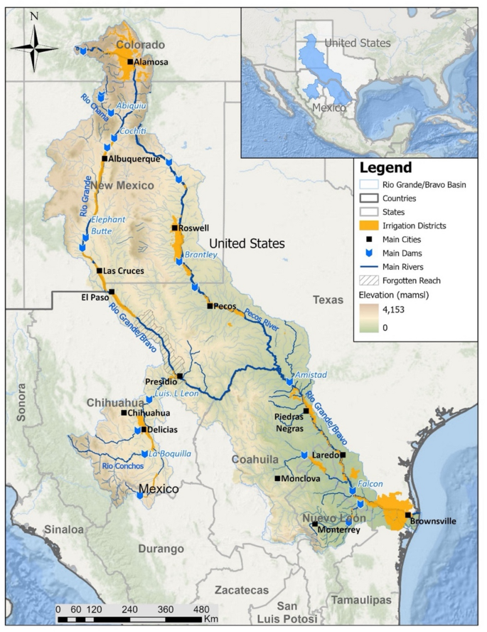
Map of the Rio Grande-Bravo basin
A multi-decadal megadrought has substantially reduced water supplies in the RGB. Since 2000, snowmelt inflows from the basin’s headwaters in Colorado have been 17% lower than during the twentieth century [10]. Climate scientists have reframed the long-running drought as the onset of long-term aridification and are forecasting additional river flow diminishment of 16–28% in coming decades as the climate continues to warm [11]. These climate-induced flow declines have greatly increased the challenge of balancing water consumption with renewable replenishment.
Despite attempts by both urban and agricultural water users to reduce their consumption [12], a persistent imbalance between water consumption and replenishment has led to severely depleted reservoirs, aquifers, and river flows throughout the RGB basin. As a result, farmers dependent upon irrigation and numerous cities face an existential water crisis. In the San Luis Valley of Colorado (Fig. 1), diminished river flows and aquifer recharge have led to continued over-pumping, causing aquifer levels to decline [13]. The Colorado state engineer has threatened to shut off hundreds of groundwater wells if the aquifer supporting irrigated farms cannot be stabilized [14]. In New Mexico, reservoir storage fell to just 13% of capacity by the end of 2024, and reservoirs in the Rio Conchos sub-basin of Mexico have fallen to under 20% of their capacity, increasing the vulnerability of drying up completely with just one or two more dry years.
Reduced water supplies have also led to political and legal disputes among state and national governments. In 2013, Texas sued New Mexico in the US Supreme Court over repeated failure to receive its annual water deliveries as specified under the interstate Rio Grande Compact [15]; the case has yet to be decided. Mexico’s shortfalls in delivering water to the US as specified under the 1944 “Treaty on Utilization of Waters of the Colorado and Tijuana Rivers and of the Rio Grande” has raised tension between the two national governments [15,16,17].
1.1 Impacts on biodiversity, farmers, and cities
The RGB basin is renowned for its biological diversity and endemism, supporting more than 130 mammals, 3,000 plant and 500 bird species [2]. Wetlands and riparian forests supported by the river are critically important to birds migrating along the Central Flyway [18]. Nearly half of the basin’s native fish species are found nowhere else, but flow depletion has become a major factor in the imperilment of at least 75 freshwater species supported by the river system [19].
The river and underlying aquifers provide drinking water for more than 11 million people in Mexico and 4 million in the US and are used to irrigate more than 7,800 km2 (1.9 million acres) of farmland in the two countries [2]. As a result of decreased river flows and depleted water storage, farmers on both sides of the border have experienced severe reductions in irrigation supplies from surface water, leading to increased groundwater pumping [17]. In many recent years, no surface water has been available after June in a region with a growing season typically lasting through October. Summer monsoon rains in 2025 provided farmers in the Middle Rio Grande Conservancy District in central New Mexico two extra weeks of irrigation until mid-July, while farmers in irrigation districts along the Texas portion of the Pecos River and in the Rio Conchos basin of Mexico did not receive any surface water supplies at all. Rapidly growing urban populations and industries in the RGB basin are also becoming increasingly vulnerable to water scarcity [20].
Despite the great scarcity of water and intensifying water shortages in the RGB basin, a full basin-wide accounting of consumptive water uses and losses has never been undertaken. In this study we assemble detailed estimates of water consumption (water withdrawals minus return flows) from a broad array of sources to reveal how surface and ground water was consumed in each of 14 sub-basins during recent decades. We have also developed estimates of changes in reservoir storage, groundwater volumes, and annual river volumes to quantify the degree to which annual water consumption has exceeded annual replenishment in recent decades.
2 Results
2.1 Accounting for consumptive water uses
An important first principle in resolving water scarcity is to develop a sound understanding of how water is consumed in a river basin [21]. Such accounting enables consideration of which water-use sectors may be able to reduce water use to the degree needed to rebalance consumption with replenishment.
In this study we have accounted for all water consumed in the Rio Grande-Bravo basin, based on three “direct use” categories and two “indirect use” categories. The direct use categories—in which water is directly used for human purposes—include municipal & commercial; thermoelectric generation at power plants; and crop irrigation including a small volume of water exported out of the basin for agricultural use. The agricultural use is further differentiated by individual crops grown in the basin to help facilitate discussions about the potential water benefits of transitioning to alternative crop mixes [22]. The indirect categories include reservoir evaporation and riparian evapotranspiration (ET). The annual average volume of water consumed in each category has been estimated for the entire basin and each sub-basin shown in Fig. 2, with results summarized in Fig. 3 and Table 1 (a tabular summary in Imperial units is provided in Supplementary Information Table SI-1).
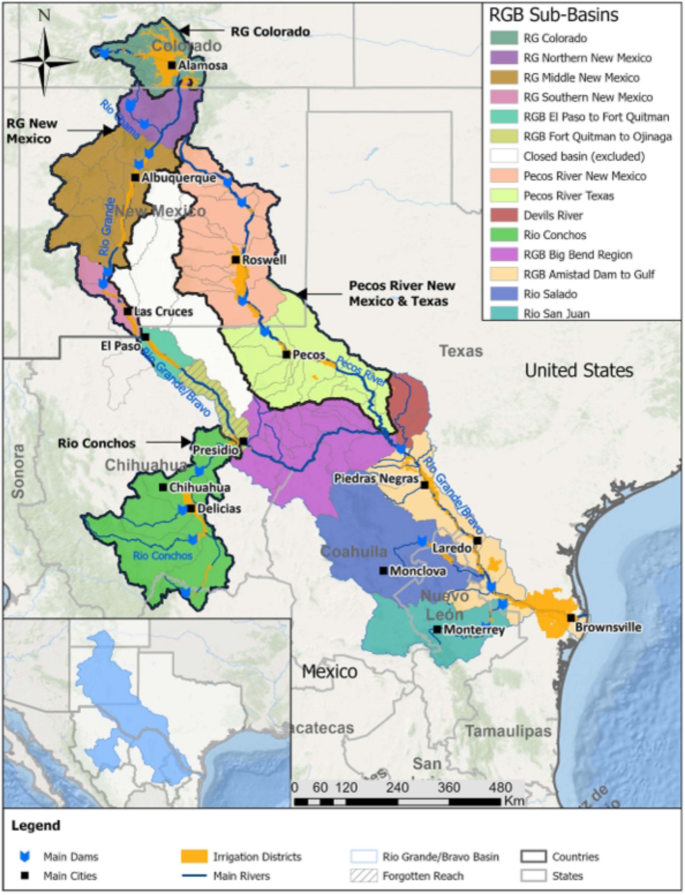
Sub-basin accounting units. This map illustrates the locations of the 14 sub-basin accounting units used in quantifying water consumption, as well as four focal areas for which additional analysis and summary statistics have been compiled. The area identified as “Closed Basin” was excluded from the analysis because water in this basin is hydrologically disconnected from other sub-basins
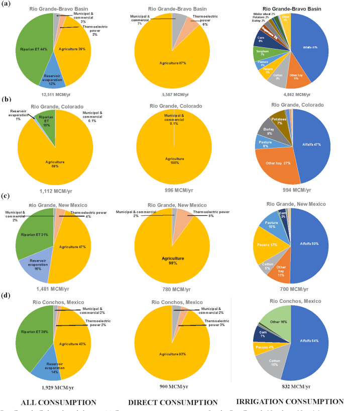
Consumptive water uses across the RGB basin. a Consumptive use percentages across the entire RGB basin; b Consumptive use percentages for the Rio Grande Colorado sub-basin; c Consumptive use percentages for the Rio Grande New Mexico focal area delineated in Fig. 2; d Consumptive use percentages for the Rio Conchos sub-basin. Percentages may not total to exactly 100% due to rounding
Compiling estimates for consumptive use across multiple states and two countries required use of data that were collected by numerous agencies using differing monitoring and measurement approaches, each with varying degrees of accuracy or certainty. For some consumption categories we also needed to perform extensive calculations to derive our own estimates—such as for crop water consumption, riparian evapotranspiration, or groundwater depletion—by compiling climate and satellite data from multiple sources. While we cannot offer confidence limits or assess the potential magnitude of uncertainties quantitatively, we are confident that we have used the best available approaches and methods in accessing and analyzing the data assembled. Our Methods section describes the data sources and approaches used in this study.
2.2 Irrigated agriculture dominates water consumption
As indicated by Table 1 and Fig. 3, agriculture is the dominant direct water consumer in the basin, accounting for 87% of direct consumption. In some sub-basins such as the Rio Grande in Colorado, or the Rio Conchos in Mexico, virtually all direct consumption goes to irrigated farms. Overall, agricultural consumption is nearly seven times the volume of all other direct uses combined.
Within agriculture, cattle-feed crops (i.e., alfalfa, grass hay, and pasture) account for 56% of irrigation water consumed. These crops are particularly dominant in the Northern New Mexico and Middle New Mexico sub-basins, where they consume almost all irrigation water (Table 1).
2.3 Trends in water consumption
As mentioned previously, snowmelt runoff (the primary source of water supply) has decreased in the RGB basin by 17% in the twenty-first century. At the same time, total direct water consumption has been increasing at the basin level since 2000, at the average rate of 12.1 million cubic meters/year (MCM/yr), equivalent to 9,828 acre-feet/year (AF/yr). Direct consumption has decreased on the US side at an average rate of 43.1 MCM/yr (34,960 AF/yr), primarily due to reductions in the total area of irrigated farmland. However, these gains were more than offset by increases on the Mexican side of 55.2 MCM/yr (44,788 AF/yr). Figure 4 illustrates annual volumes of consumptive use in each direct water-use category as well as the trend in overall direct water consumption, and Fig. 5 shows trends in agricultural consumption, which is by far the largest direct water-use category (trends in individual crops are illustrated in Supplementary Information Figure SI-1).
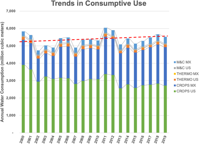
Annual volumes of direct water consumption in each water-use sector. Values in million cubic meters. M&C MX, municipal and commercial consumption in Mexico; M&C US, municipal and commercial uses in the US; Thermo MX, thermoelectric power generation in Mexico; Thermo US, thermoelectric power generation in the US; Crops MX, irrigated crops in Mexico; Crops US, irrigated crops in the US. Red dashed line indicates average annual increase in total direct consumption of 12.1 MCM/year
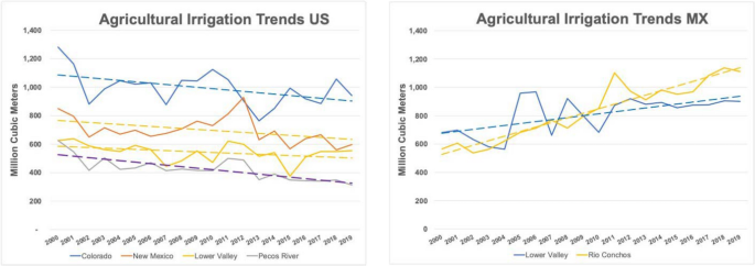
Trends in agricultural water consumption. a On the US side of the RGB basin, agricultural water consumption decreased, but b consumption has increased substantially on the Mexico side. As graphed here, “New Mexico” does not include the Pecos River within New Mexico and Texas, which is graphed separately. The “Lower Valley” on the US side includes the Devils River sub-basin and the Amistad Reservoir to the Gulf sub-basin. On the Mexican (MX) side, the Lower Valley includes the Amistad Reservoir to the Gulf sub-basin as well as the Rio Salado and Rio San Juan sub-basins
2.4 Indirect water uses are substantial
Indirect uses and losses of water—which include both riparian evapotranspiration and reservoir evaporation—account for 56% of overall water consumption in the RGB basin (Fig. 3a). Reservoir evaporation accounts for 12% of water consumption. The two biggest reservoirs on the river—Amistad and Falcon—account for 38% of all reservoir evaporation. Riparian ET is the single largest water consumption category, accounting for 44% of total water consumption.
3 Impacts of overconsumption on reservoir and aquifer storage and river outflows
A persistent imbalance between water consumption and supply has severely depleted multiple water sources in the RGB basin. The volume being depleted ‘feeds’ or enables the overconsumption [23]. We estimated the annual average volume of depletion (or gain) in each water source during 2002–2024 that helped support the consumptive uses summarized in Table 2.
The three trends used to evaluate overconsumption include volumetric changes in reservoir storage, aquifer storage, and river outflows. We assessed annual average volumetric changes for each of these three components for the four focal areas identified in Fig. 2 and the entire RGB basin, for a common period of 2002–2024. We note that some of the most severe depletions in these water sources occurred during 2000–2001, but data available on groundwater losses do not begin until 2002 (see Methods) so trends in the three water sources were assessed with 2002 as the starting point.
3.1 Loss of reservoir storage
An estimated 12% of all water stored in basin reservoirs has been lost since 2002 (average annual loss of 177.6 MCM/yr or 143,945 AF/yr). The loss of reservoir storage has been most severe in New Mexico, where 71% of the reservoir storage that existed at the start of 2002 was gone by the end of 2024 (Fig. 6). We note that due to substantial intra- and inter-annual variability in reservoir volumes, the least squares goodness of fit for our linear regressions is weak, but trends are visually apparent, nonetheless.
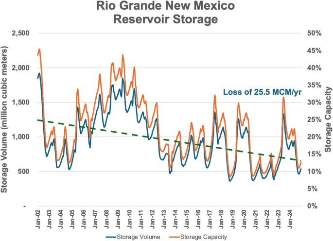
Reservoir depletion in New Mexico. Higher levels of snowmelt runoff in the Rio Grande’s headwaters during 2005–2009 helped to temporarily bolster reservoir levels in Colorado and New Mexico. However, the volume of water stored in RGB reservoirs has been declining rapidly since 2010. Total water storage in the Rio Grande New Mexico focal area fell to 13% of capacity by the end of 2024
3.2 Groundwater depletion
Groundwater depletion in the RGB basin (Fig. 7) has been much more severe (roughly 15 times greater in volume) than reservoir depletion. As surface water supplies have declined over recent decades, groundwater pumping has increased substantially [24]. An estimated 2,700 MCM/yr (2,189,000 AF/yr) of groundwater loss occurred during 2002–2024, with the Pecos River (950 MCM/yr; 770,179 AF/yr), Rio Grande New Mexico (630 MCM/yr; 510,750 AF/yr), and the Rio Conchos (490 MCM/yr; 397,250 AF/yr) experiencing the greatest overdrafts.
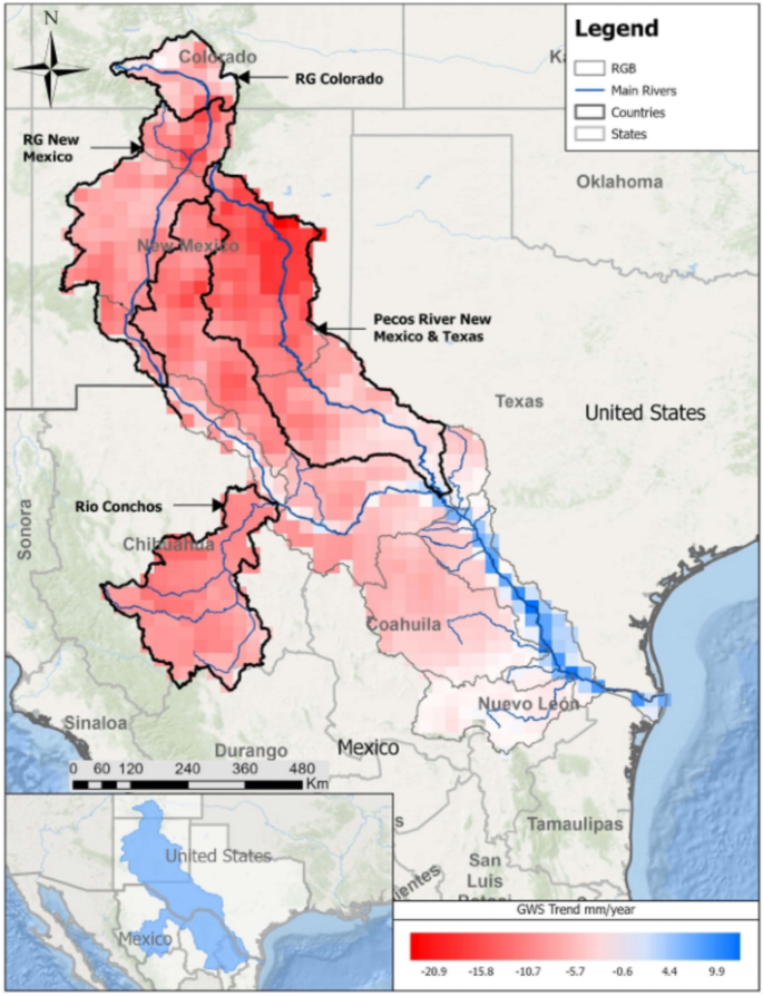
Groundwater depletion. The volume of groundwater storage (GWS) in many RGB aquifers declined substantially during 2002–2024, with particularly severe depletion in the Pecos River, Rio Grande New Mexico, and Rio Conchos of Mexico. Map indicates millimeters of change in groundwater levels, based on data from the (US) National Aeronautical and Space Administration’s Gravity Recovery and Climate Experiment (GRACE and GRACE Follow-On) satellite missions. Groundwater changes in terms of both depth (mm) and volumes (MCM/yr) are provided in Table SI-3 of Supplementary Information
3.3 Depletion of river outflows
In addition to the loss of water stored in reservoirs and aquifers, it is also important to assess trends in annual river flow volumes. Changes in total outflow provide another indicator of the sustainability of water consumption within a region and can be counted as another component of water overdraft in the basin. River outflow measured at the RGB basin outlet near Brownsville, Texas indicates annual volumetric outflow declines averaging 22.4 MCM/yr (18,147 AF/yr) since 2002. We note that this indicates ongoing (further) depletion of an already heavily depleted river that had lost ~ 85% of its flow prior to 2002. Similar to reservoir trends discussed previously, substantial intra- and inter-annual variability in river outflow volumes causes the least squares goodness of fit for our linear regressions to be weak, but trends are visually apparent, nonetheless.
3.4 Quantifying the proportion of direct consumption that is unsustainable
The three sub-components of change used to evaluate overconsumption include reservoir storage, aquifer storage, and river outflow volumes. Summing these three sub-components at the full basin level results in average annual water depletion totaling 2,900 MCM/yr (2,351,092 AF/yr) since 2002. By dividing the average volume of annual depletion by the average annual volume of direct water consumption in each sub-area we obtain estimates of the degree (%) of overconsumption (i.e., unsustainable use). At the whole basin scale, 52% of direct consumption is unsustainable. However, overconsumption is much greater in some sub-areas of the basin such as in the Pecos River in New Mexico and Texas, where 140% of all water directly consumed is unsustainable (overconsumption is 66% of total water consumption), and in the Rio Grande New Mexico sub-basins where 85% of direct consumption is unsustainable. Table 2 provides over-consumption estimates for the overall basin and four focal areas identified in Fig. 2. Figure 8 illustrates the role of water depletion in supporting the RGB basin’s overconsumption.
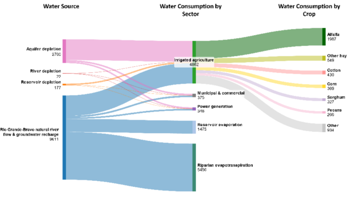
Water sources and consumptive uses in MCM/year. This diagram illustrates the role that water source depletion is playing in enabling the over-consumption of water in the RGB basin since 2002. The water sourced from the RGB’s natural river flow and groundwater recharge is deemed to be the sustainable portion of water supply. The remainder of water needed to support direct consumptive uses is being provided by (unsustainable) depletions of annual river volumes, aquifers, and reservoirs in the basin
4 Discussion
The water scarcity challenges within the RGB basin have received much less attention from media outlets and national policymakers as compared to the Colorado River Basin (CRB) in the American Southwest. This can largely be explained by the comparatively smaller volume of water it carries (natural flows of 11,225 MCM/yr or 9.1 million AF/yr) in the RGB [25] vs. 18,996 MCM/yr (15.4 million AF/yr) in the CRB [26], as well as the smaller population it serves with drinking water (15 million in RGB vs. 40 million in CRB) and the area of irrigated farmland it supports (7,800 km2 in RGB vs. 22,300 km2 in CRB) [2]. However, the water crisis facing the RGB is arguably more severe and urgent than the CRB, as illustrated by these conditions:
-
Groundwater in the San Luis Valley of Colorado has been depleted at a rate of 110 MCM/yr ((89,179 AF/year), equivalent to 11% of the annual average of direct water consumption in the valley (Table 2). The state’s engineer has threatened to shut off hundreds of groundwater wells if the aquifers cannot be stabilized and restored to near 1976 levels [27, 28]. A water conservation program has been charging farmers to pump groundwater and has paid farmers since 2012 to fallow farm fields voluntarily, yet aquifer levels continue to fall [29]. Efforts to recover these aquifers have been greatly impacted by 17% declines in snowmelt runoff this century.
-
New Mexico has fallen into water debt to Texas under the terms of the interstate Rio Grande Compact, leading to a lawsuit before the US Supreme Court [15]. New Mexico’s cumulative debt to Texas as of December 2024 was 153 MCM (124,000 AF). New Mexico’s water debt poses an extremely difficult challenge for the state given that it has also lost much of its reservoir and aquifer storage in recent decades, and climate warming is projected to further reduce the state’s water supplies by 16–28% in coming decades [11].
-
In recent years, Mexico has fallen into mounting water debt to the US under the terms of the 1944 Treaty on Utilization of Waters of the Colorado and Tijuana Rivers and of the Rio Grande [30]. Mexico’s water debt—which amounted to 1,280 MCM (1.04 million AF) at the end of 2024—is causing political conflict between the two countries. The current federal administration in the US asserts that Texas farmers along the lower Rio Grande-Bravo have been unduly suffering from water shortages [31]. Texas farmers in the lower valley experienced losses of nearly USD$500 million in 2024 due to insufficient irrigation supply [32]. At the same time, Mexican farmers are also experiencing irrigation shortfalls and associated crop losses [17].
The severe water crisis emerging in the RGB basin requires urgent action. At the end of 2024, total reservoir storage in the basin stood at just 26% of capacity (~ 4.24 million AF) and has continued to decline in 2025. Within the Rio Conchos sub-basin in Mexico, reservoirs were at 20% of capacity at the end of 2024. In New Mexico, reservoirs were at 13% of capacity within the Rio Grande sub-basins, and 12% in the Pecos River sub-basins in New Mexico and Texas. Without a substantial reduction of water consumption, a repeat of the four-year rate of reservoir depletion experienced in 2010–2013 would completely wipe out all remaining surface water stored in the RGB basin. All remaining water stored in New Mexico reservoirs could be gone in just one or two low runoff years.
Notably, large cities such as Albuquerque and El Paso have been able to substantially lower their water use even while their populations have grown rapidly in recent decades. For example, Albuquerque’s population grew by 40% while its water use declined by 17% [33], and El Paso’s population grew by 36% while water use declined by 6% [34]. Additional urban water conservation could help alleviate water over-consumption in the basin. However, given that municipal and commercial water consumption account for only 7% of all direct consumption in the basin, reductions in urban water use will do little to rebalance water consumption with replenishment. Even if cities and power plants in the basin were able to stop using water altogether, it would reduce the basin’s overconsumption by only 25% (Table 1). Additionally, continued rapid population growth and development of water-intensive data centers [35] will challenge most cities in simply holding water use levels constant in coming years.
Most of the needed water savings must come from irrigated agriculture, given its dominant 87% share of direct water consumption. Proven strategies for reducing consumption in irrigated agriculture exist [22, 36] but must be rapidly deployed at sufficient scale and financially sustained by governments, companies, and credit institutions to rebalance the basin’s water budget at sub-basin, state, and binational levels. Achieving necessary levels of reduction in consumptive use will be extremely difficult given the high levels of over-consumption existing presently (Table 2), as well as expected declines in water availability due to climate change and associated increases in fire frequency and severity (see Supplemental Information for discussion of fire impacts).
Understandably, farmers are strongly resistant to mandatory cutbacks in water use as irrigation is essential to their livelihoods in the dry climate of the RGB basin. For instance, when the Mexican federal government began releasing water from a large dam on the Rio Conchos in 2020 to comply with the international water treaty between Mexico and the US, more than 2,000 protestors fearing loss of their scarce irrigation supplies erupted into violence, resulting in the death of a protestor [30, 37]. Political leaders and water managers have been loath to mandate water-use reductions in the face of such resistance and hostility. Voluntary water conservation programs that pay farmers to temporarily fallow farmland have been implemented in both Colorado and New Mexico, but these programs have never achieved targeted reduction levels due to an inability to offer sufficient financial incentives to participants [27]. Given the recent elimination or reduction of US federal programs that have helped finance these water conservation programs, the funding challenge will fall largely on already-strained state and local budgets.
4.1 Institutional challenges
The RGB has a fragmented water governance that is to some degree stitched together by multiple interstate and international water agreements. The regulatory autonomy of individual states within the US and among irrigation districts in Mexico—and the absence of a basin-wide planning commission—complicates the ability to conduct trans-boundary water planning exercises and largely explains why basin-wide accounting of water use has not been undertaken until now.
Within the US, each state manages water rights and allocations independently, conditioned only by interstate legal agreements such as the Rio Grande Compact and the Pecos River Compact. An additional challenge is that within each state, multiple water and natural resource agencies or departments operate according to their own legislatively mandated responsibilities, oftentimes without sufficient coordination and collaboration among agencies. While the problem of water overconsumption is evident, these jurisdictional separations too often frustrate coordinated action that require integrated institutional alignment and strong political will.
Conceptually, Mexico should have stronger governance capabilities because there is only one regulatory framework (Ley de Aguas Nacionales or National Water Law) and one regulatory water agency (CONAGUA) in the country. In practice, however, water management remains fragmented due to the role of irrigation districts. As summarized in this paper, irrigated agriculture is by far the largest water user throughout the RGB basin, and in Mexico irrigation districts largely control the distribution of water resources. Each irrigation district is located along a river and downstream of a dam in which virtually all available water in the river is stored and allocated within the irrigation district. Rivers have become disconnected throughout the basin and water is rarely conveyed among reservoirs, except when water deliveries from Mexico to the U.S. are lagging and coordinated reservoir releases are needed to meet treaty requirements.
The existing interstate and international agreements governing water sharing in the RGB have the great benefit of ‘pulling’ water downstream across these fragmentations, however; it is quite plausible that in absence of these agreements there would be no water moving from Colorado to Texas, or from tributaries in both countries into the Rio Grande. Additionally, the under-delivery of water across state and international boundaries as required by these water-sharing agreements may trigger forcing mechanisms (i.e., through court cases) that stimulate urgently needed water-use reductions within each sub-basin, helping to rebalance consumption with available supplies and moving sub-basins toward long-term sustainability.
Existing water planning systems within the US states and Mexico should provide useful platforms for facilitating the challenging but necessary dialogue and decision-making about how to substantially reduce water consumption. Regional Water Planning Groups with diverse sectoral representation were activated in Texas in 1997, Colorado similarly launched Basin Roundtables in 2005, and New Mexico has established Regional Water Security Planning Councils that will become active in 2026. Similarly, River Basin Councils (Consejos de Cuenca) were established in Mexico in 2004. These planning entities now face unprecedented challenges to rapidly reduce water consumption to the degree outlined in Table 2.
5 Conclusions
If water consumption cannot be substantially reduced through regulatory or incentivized means, a likely outcome will be continued loss of farmland due to financial insolvency from lowered crop production and other factors including the aging of farmers and lack of affordable farm labor [38]. Our analysis reveals that during 2000–2019, Colorado lost 18% of its farmland in the RGB basin, New Mexico lost 28% along its Rio Grande sub-basins, and the Pecos River sub-basin lost 49%. While this loss of farmland explains much of the reduction in US agricultural water consumption illustrated in Fig. 5a, farmland attrition due to financial insolvency is not a desirable strategy for reducing water consumption. Strategies for reducing farm water use must be carefully planned and executed with consideration of social, cultural, economic, and environmental impacts.
It is important to acknowledge that urban and agricultural water conservation programs have thus far been unable to produce the reductions in water consumption required to stabilize—much less restore—the water sources within the RGB [27]. It is also highly unlikely that imported or desalinated water sources will resolve this crisis, given that the costs of such importation or treatment will not be affordable for farmers. The unaffordability of new supplies leaves only three plausible non-exclusive options: (1) transform the agricultural landscape to produce crops that require little to no irrigation [22]; (2) financially incentivize ‘deficit irrigation’ to substantially reduce the duration of irrigation during the growing season [39]; or (3) permanently convert some portion of irrigated farmland to other uses such as wildlife habitat, solar farms, or other purposes that require much less water. If water consumption for municipal, commercial, and thermoelectric power generation remains constant, irrigation reductions would need to be at the level of over-consumption indicated in Table 2.
Given severe groundwater depletion across much of the RGB basin, an immediate first step should be to place a moratorium on new wells in over-drafted areas of the basin (Fig. 7). Moratoriums would need to be supplemented with sub-basin groundwater pumping caps (limits) that reduce the total volume of pumping to a level that halts groundwater depletion and stabilizes aquifer levels. Wight et al. (2025) [40] surveyed nearly 50 global case studies where caps on surface water diversions and groundwater pumping have been imposed; many of these cases focused on aquifer management, and many have successfully averted or reversed groundwater depletion. However, it is also important to note the causes of failure in many cases highlighted by Wight et al., including inabilities to enforce such restrictions adequately. Moratoriums have been set for many over-exploited aquifers in Mexico including in the RGB basin, but these efforts have been plagued by enforcement shortcomings [41].
This water crisis presents an opportunity for the residents of the RGB to envision a new, more sustainable water future. The ‘Multi-benefit Land Repurposing Program’ underway in the water-stressed Central Valley of California provides one example of productive community dialogue around possible future scenarios [42]. The “Exploratory Scenario Planning” approach being advanced by the Lincoln Institute of Land Policy in various communities in the western US similarly offers ways to engage local communities in planning for their water future [43]. Any transformational strategies will require careful and inclusive planning, provision of strong financial incentives for farming communities to facilitate needed changes, and a bold willingness of water management agencies and decision makers to ensure water and food security for the region. Alternate pathways toward a sustainable water future are available for the RGB basin, but time is of the essence in correcting the highly unsustainable conditions that presently exist.
6 Methods
6.1 Estimating municipal & commercial water consumption for US sub-basins
Municipal and commercial consumptive use estimates were sourced from the United States Geological Survey’s (USGS) public supply reanalysis dataset for 2000–2020 [44, 45]. This dataset applies a machine learning model to refine water use estimates using existing USGS data and supplemental inputs from local, state, and federal sources, aiming to improve spatial and temporal resolution and standardize estimation methods across sectors. The public supply delivery model provides monthly estimates of withdrawals and consumptive use (in million gallons per day) for domestic, commercial, industrial, institutional, and irrigation (MCI/CII) uses at the Hydrologic Unit Code 12-digit (HUC12) or Water Service Area (WSA) scale. For this study, we used total consumptive use (surface water + groundwater) estimates at the HUC12 level, reflecting the complex and dynamic interactions between surface and groundwater in the basin.
For each HUC12 unit h, we aggregated the monthly public supply consumptive use estimates for each year t and multiplied the sum by 365.25 to convert to annual total use in million gallons. This produced annual consumptive use estimates for each HUC12 from 2000 to 2020. These values were spatially referenced by merging with the USGS’s Watershed Boundary Dataset [46], which defines the geographic extents of each HUC12.
To assign these calculated values to the relevant sub-basins in our study area, we used spatial intersection [47]. Because some HUC12s extend across multiple sub-basins, we apportioned their annual consumptive use proportionally based on the area of overlap. Specifically, for each intersecting pair of HUC12 h and sub-basin s, the portion of h's annual use attributed to s was weighted by the ratio of the area of h within s to the total area of h.
It is important to note that our Municipal and Commercial estimates do not include self-supplied domestic and industrial water use, which we know are present in the basin [48]. However, these self-supplied uses are known to be quite small relative to public supplies. In 2015, self-supplied uses accounted for less than 2% of all water withdrawals in the Upper Rio Grande above Fort Quitman, Texas [48], and most of this self-supplied water was returned to surface and groundwater systems after domestic or industrial use.
6.2 Estimating municipal & commercial water consumption in Mexican sub-basins
Estimates of 2000–2020 annual water use for domestic and manufacturing water consumption in Mexico were obtained from the WaterGAP global hydrologic modeling team at the University of Kassel, Germany [49]. The gridded WaterGAP water use data were aggregated to the RGB sub-basins in a Geographic Information System.
6.3 Estimating thermometric power plant water consumption for US sub-basins
Thermoelectric power plant water use values for the US were obtained from the recent USGS reanalysis of the thermoelectric power plant water use dataset [50]. This dataset provides monthly water withdrawal and consumption values from 2008 to 2020 at the HUC-12 scale. Using the HUC-12 basins on the US side of the RGB basin, we summed the thermoelectric water use values into their respective HUC-8 basin-scale membership. To obtain water use estimates for missing data between 2000 and 2007, we developed a backcasting Seasonal Autoregressive Integrated Moving Average (SARMIA) time series model [51, 52]. After testing both pooled and per-plant specifications, we adopted individual SARIMA models for each HUC-12 containing thermoelectric records, as pooled models performed poorly and produced implausible dynamics. This design captures local temporal dynamics, preserves facility-level heterogeneity, and provides conservative, reproducible estimates of historical water use continuity rather than high-precision reconstructions of plant-level variability. Model performance was evaluated using mean absolute error (MAE) and root mean square error (RMSE), which ranged from 0.11–2.51 to 0.15–4.78 Mgal/day, respectively (Table SI-3), and all backcasts were generated with 95% confidence intervals (Figures SI-3–SI-10). We acknowledge that this methodological choice introduces limitations, particularly residual non-normality and occasional heteroskedasticity, and adds some bias and uncertainty to the backcasted values; however, we view these impacts as acceptable trade-offs to ensure basin-scale continuity under significant data constraints. For detailed model specifications and results, see Supplemental Information discussion including Table SI-3 and Figures SI-3–SI-10.
6.4 Estimating thermoelectric power plant water consumption for Mexican sub-basins
Annual estimates of thermoelectric water consumption for the Mexican portion of the RGB basin from 2000 to 2020 were obtained from the Estadísticas del Agua en México annual reports and the Compendio Básico Del Agua en México reports published by the Sistema Nacional de Información del Agua [53]. There were missing thermoelectric water consumption values for the years 2000, 2002, 2003, and 2004 as the value was combined with industrial water consumption. Additionally, in 2011 and 2012 only thermoelectric water withdrawal were reported. To address this gap we obtained the thermoelectric water consumption value for 1998 and used this as the starting value to linearly interpolate across the 1998–2020 period to fill these data gaps.
The resulting annual values for the RGB basin were then proportionally allocated to individual Mexican HUC-8 basins based on the installed total generation capacity (in megawatts) and the operational start year of each thermoelectric power plant. Information on installed plant generation capacity and commissioning dates was manually collected from the Global Energy Monitor Wiki [54]. Unfortunately, the only plant operational characteristics that were accessible were the plant’s fuel, generator technology, spatial coordinates, and generation capacity. This approach assumes that water use scales linearly with installed capacity and does overlook differences in cooling technologies, fuel types, or efficiency upgrades that affect water use intensity; however, this approach was necessary given the lack of detailed, plant-level operational data. For a detailed explanation of the interpolation and proportional allocation processes, see Supplemental Information discussion including Tables SI-4 and SI-5.
6.5 Estimating crop water consumption for US sub-basins
We determined volumetric crop water requirements (VCWR) for 30 major crops (see Table 3 for acreage estimated for the RGB basin), accounting for 94.2% of the total irrigated area in the US [55], for the period 2000–2019. The VCWR for each crop was calculated by taking the product of the crop water requirement (CWR), measured as the depth of consumed water per unit area, by a crop’s irrigated harvested area within each 2.5 arc-minute grid cell within the conterminous United States (CONUS). The CWR for these crops was adapted from Modeled Irrigated Agriculture of the United States (MirAG-US), which provides monthly blue and green CWR at a 2.5 arc-minute resolution for CONUS [56]. The irrigated harvested areas for the 30 major crops were obtained from HarvestGRID, which provides yearly crop-specific irrigated acreage, at a 2.5 arc-minute resolution across CONUS [57]. We aggregated the monthly blue and green CWR to obtain yearly CWR and calculated the crop-specific VCWR using the corresponding yearly CWR and irrigated harvested area.
For pastureland, which MirAG-US does not account for but is widely irrigated in the basin, we estimated VCWR by leveraging CWR, both blue and green, for alfalfa from MirAG-US. For locations where pasture/hay was cultivated within individual subbasins, we obtained the annual green CWR for pastureland by averaging the green CWR for alfalfa at a subbasin scale. We estimated the annual blue CWR for pastureland at the subbasin level by adjusting the blue CWR for alfalfa using the reported applied irrigation depth from the Irrigation and Water Management Surveys for the years 2003 [58], 2008 [59], 2013 [60], and 2018 [55]. The adjustment factor was derived by calculating the state-average irrigation depth ratio between pastureland and alfalfa in New Mexico, where most of the study area is located. Subsequently, this adjustment factor was multiplied by the annual alfalfa blue CWR for each 2.5 arc-minute grid cell and then averaged across the subbasin.
To identify irrigated pasturelands at the subbasin level, we combined National Land Cover Database (NLCD) [61] 30 m resolution rasters with the corresponding Landsat-based National Irrigation Dataset (LANID) [62] 30 m resolution rasters. Since NLCD classifies both pasture and hay under a single category, we calculated the effective pastureland area of each subbasin by subtracting irrigated other hay areas from irrigated pasture/hay areas from NLCD. For 2008–2019, a combination of the Cropland Data Layer (CDL) [63] and LANID were used to identify irrigated other hay, which was then subtracted from NLCD’s pasture/hay category. For pre-2008 years when CDL data were not available, we used average subbasin-level irrigated area for other hays calculated from available years, which was then subtracted from NLCD to estimate irrigated pastureland. The VCWR for pastureland was determined at the subbasin level according to Eq. 1.
$$ {\text{VCWR}}_{{{\text{Pastureland}}}} = {\text{adjustment factor}}* {\text{CWR}}_{{{\text{alfalfa}}}}^{ } { }* ({\text{area}}_{{\text{pasture/hay, irrigated}}}^{{{\text{NLCD}}}} { } - {\text{area}}_{{\text{other hay, irrigated}}}^{{{\text{CDL}}}} ) $$
(1)
where, subscripts denote the crop type and superscripts NLCD and CDL denote the data sources of irrigated crop acreage We note that the adjustment factor is applied only to blue CWRs.
6.6 Estimating crop water consumption for Mexican sub-basins
Actual evapotranspiration (ET) for major annual crops in Mexico was simulated using the Environmental Policy Integrated Climate (EPIC) model [64, 65] at a 30-arcminute spatial resolution, with crop-specific parameters assigned to each crop type. Perennial crops, including fruit trees and alfalfa, were modeled separately using the CropGBWater model—a Python-based global gridded tool designed to estimate green and blue water consumption in crop production [66].
To distinguish between rainfed and irrigated agriculture, we used municipal-level agricultural statistics from Mexico [67] to generate harvested area maps at a 5-arcminute resolution for the major crops. Combined with the ET outputs from the crop models, these maps were used to compute green and blue water consumption for crop production at 5-arcminute resolution. The resulting grid-level estimates were then aggregated to the sub-basin scale using sub-basin polygon boundaries. These estimates were further verified using data from the Comision Nacional del Agua’s Agricultural Statistics database [68], using some of the main irrigation districts for comparisons.
6.7 Estimating reservoir evaporation
To estimate monthly evaporative water loss from reservoirs we utilized the Global Lake Evaporation Volume dataset [69]. This dataset provides evaporation estimates for global lakes and reservoirs derived from the HydroLAKES database [70]. We spatially associated each lake with its corresponding sub-basin by overlaying the HydroLAKES dataset with a delineated RGB sub-basin layer. Through this spatial intersection, we identified 37 reservoirs within the basin (Table SI-2). We computed the annual mean evaporation during 2000–2018 for each of these reservoirs using their monthly evaporation values over the study period.
6.8 Estimating riparian evapotranspiration
Riparian and wetland vegetation along the RGB river corridor were mapped at ~ 30 m resolution using spatial data products and the Google Earth Engine Python API [71]. The riparian corridor was delineated using Strahler stream order information within the USGS’s National Hydrography Dataset Plus version 2 [72] and Mexico’s RED Digital Hydrographic database [73]. The total width of the riparian corridor for each stream segment was established based on the corresponding Strahler stream order designation [74]. The valley floor within the river corridor was delineated using the Global Shuttle Radar Topography Mission Landforms dataset (~ 90 m resolution) [75]. Riparian and wetland vegetation within the riparian corridor’s valley floor was mapped annually over the 2000–2022 period by masking out cropland, bare ground, impervious surfaces, and water/snow/ice from the Global 30 m Land Cover Change Dataset [76].
Total annual ET (AF/yr) of riparian and wetland vegetation mapped within the RGB sub-basins were estimated over the 2000–2022 period using OpenET [77] (~ 30 m resolution) for the United States and the Penman–Monteith-Leuning Evapotranspiration V2 (PML-V2) product [78,79,80] (~ 500 m resolution) for Mexico. OpenET estimates were prioritized for riparian and wetland vegetation, and PML-V2 estimates were used where OpenET data were not available. The PML-V2 estimates include a sum of the vegetation transpiration (Ec), soil evaporation (Es), and interception from vegetation canopy (Ei) bands. Total annual precipitation was also estimated for riparian and wetland vegetation over the 2000–2022 period using gridMET [81] (~ 4.6 km resolution). For each basin, the median evapotranspiration and precipitation values for riparian and wetland vegetation were calculated. Precipitation-derived ET is highly variable across riparian and wetland vegetation and depends on the species and water table depth [82,83,84]. Based on our review of literature cited here, we assume that half of the annual precipitation supports riparian ET, either directly as enhanced soil moisture or indirectly as monsoon runoff. Total annual ET was calculated per basin by subtracting half of the precipitation depth from the ET depth and then converted into volumetric units by multiplying the annual riparian area.
6.9 Estimating inter-basin transfer volumes
Using the Interbasin Transfer Database Standard Version 1.0 (IBTDS 1.0) [85], we identified 54 unique interbasin water transfer (IBT) projects comprising 274 transfer links within the RGB basin. Of the 274 identified links, 16 links (corresponding to 14 unique IBT projects) had water transfer volumes: 13 included average and daily time series data, while 3 had only average transfer volumes. Among the 13 links with daily time series data, 12 links (corresponding to 10 unique projects) contained records covering all or part of the 2000–2019 study period. For each of these 12 links, we assessed the completeness of daily flow data and retained only those years with complete daily records (i.e., no missing values). We then calculated total annual transfer volumes for each valid year and computed the mean annual IBT volume by averaging across the valid years. Many of the IBTs in the RGB basin are small and may represent seasonal water transfers. While the larger IBT projects are well represented in the dataset, particularly those with associated flow data, some small IBTS may not be captured by IBTDS 1.0.
6.10 Estimating depletion of river outflow volumes
Annual runoff volumes were obtained from the USGS’s “Water Data for the Nation” webpages [86] and the International Boundary & Water Commission [87]. Data were obtained from monitoring stations closest to each river’s exit from a sub-basin that included measurements for the 2002–2024 period of record. These gauges include the Rio Grande at Lobatos, CO; Rio Grande below Elephant Butte Reservoir, New Mexico; Rio Conchos near Ojinaga, Mexico; Pecos River near Girvin, Texas; and Rio Grande at Brownsville, Texas. The average annual rate of change was estimated using the slopes of the linear regression lines.
6.11 Estimating reservoir depletion volumes
Daily estimates of reservoir volume were obtained from multiple sources including the US Bureau of Reclamation’s “Reclamation Information Sharing Environment (RISE)” webpages [88], the Natural Resources Conservation Service’s “Air & Water Database Report Generator” webpages [89], the Texas Water Development Board’s “Water Data for Texas” webpages [90], and the International Boundary & Water Commission’s “Water Data Portal” webpages [87]. A listing of reservoirs used in estimating evaporation is provided in Table SI-2. The average annual rate of change was estimated using the slopes of the linear regression lines.
6.12 Estimating groundwater depletion volumes
We followed Rodell and Famiglietti [91], Yeh et al. [92], Rodell et al. [93], and Rodell et al. [94] to estimate groundwater storage changes using NASA GRACE and GRACE Follow-On (GRACE/FO) satellite observations from 2002 to 2024. The GRACE/FO missions provide monthly observations of Earth's gravity field, which are used to estimate changes in TWS at local and global scale [95, 96]. These GRACE data are particularly useful for monitoring groundwater and other water components that are difficult to measure directly [97, 98]. The GRACE/FO mascon solutions offer improved spatial pixels resolution and reduced leakage compared to earlier GRACE spherical harmonic data (GRACE-SH), enhancing hydrological applications in complex hydrological systems [99].
In this work, we used the average of three mascon solutions: NASA’s Jet Propulsion Laboratory (JPL-RL06.1 M [100], the University of Texas Center for Space Research (CSR-RL06.02 M [101]), and NASA Goddard Space Flight Center (GSFC-RL06v2.0 M [99, 102, 103] for our TWS estimates.
We analyzed total water storage (TWS) variations across the entire RGB and its sub-basins. Groundwater storage (GWS) variations were derived by subtracting measured surface water reservoir storage (SWRS) and modeled soil moisture storage (SMS) and from TWS. The SWRS variations were estimated by compiling daily storage data for major RGB reservoirs from data sources stated in Sect. 5.11 above. SMS was obtained from the North American Land Data Assimilation System (NLDAS) [104], which includes three land surface models (NOAH, VIC, and MOSAIC) [91,92,93,94]. NLDAS integrates multiple land surface models to provide high-resolution hydrometeorological variables across the continent. It offers gridded outputs of soil moisture, evapotranspiration, and surface runoff, among others. This case study used SMS from three NLDAS models to isolate groundwater storage variations. Snow water equivalent (SWE) was not included in this analysis, as it contributes minimally to total water storage across most of the RGB, particularly outside the headwater regions, and is commonly excluded in similar large-scale groundwater assessments [94].
To isolate long-term trends and suppress the seasonal signal, we applied Seasonal-Trend decomposition using LOESS (STL) to all monthly time series of all water compartments (TWS, SWRS, SMS, and GWS). STL's an iterative, non-parametric decomposition procedure that separates a time series into three components (trend, seasonal, residual). This process involved first filling in any missing monthly values using linear interpolation. Next, the time series were decomposed into seasonal and trend components using the STL (Seasonal-Trend decomposition based on LOESS) method. Finally, the deseasonalized component, representing the long-term trend, was extracted from the original series [105, 106]. The resulting nonseasonal time series were then used to calculate annual and decadal trends in water storage across the basins.
Uncertainty in TWS was assessed by calculating the standard deviation among the three GRACE/FO solutions. For SMS, uncertainty was estimated as the standard deviation among the three NLDAS models (NOAH, VIC, and MOSAIC). Since reservoir storage datasets did not include error estimates, we followed Liu et al. [98] in assigning a 15% uncertainty to the SWRS values. The overall uncertainty in GWS (σGWS) was determined by combining the individual uncertainties from TWS, SWRS, and SMS in quadrature (Eq. 2)
$$ \sigma {\text{GWS}} = \sqrt {(\sigma {\text{TWS}})^{2} + (\sigma {\text{SWRS}})^{2} + (\sigma {\text{SMS}})^{2} } $$
(2)
Data availability
Data sets generated during the current study are available from the corresponding author on reasonable request.
Notes
The river is known as the Rio Grande in the US but is the Rio Bravo in Mexico. We have combined these names as Rio Grande-Bravo (RGB) in this paper.
References
Pratt SE. Rio Grande runs dry, then wet. NASA Earth Observatory; NASA Earth Observatory. Retrieved July 18, 2023, (2022, August 23). From https://earthobservatory.nasa.gov/images/150244/rio-grande-runs-dry-then-wet.
Richter BD, Prunes E, Liu N, Caldwell P, Wei D, Davis KF, et al. Opportunities for restoring environmental flows in the Rio Grande-Rio Bravo basin spanning the US–Mexico border. J Water Resour Plann Manage. 2024;150(2):04023079. https://doi.org/10.1061/JWRMD5.WRENG-6278.
Coyro EE. El tratado entre México y los Estados Unidos de América sobre ríos internacionales: una lucha nacional de noventa años. Universidad Nacional Autónoma de México; 1976.
Everitt B. Channel responses to declining flow on the Rio Grande between Ft. Quitman and Presidio, Texas. Geomorphology. 1993;6(3):225–42. https://doi.org/10.1016/0169-555X(93)90048-7.
Olson KR, Lang JM. Rio Grande an International Boundary River is drying up and in need of restoration. Open J Soil Sci. 2021;11(12):587–610. https://doi.org/10.4236/ojss.2021.1112029.
Garza-Díaz LE, Sandoval-Solis S. Changes in the stability landscape of a river basin by anthropogenic droughts. Water. 2022;14(18):2835. https://doi.org/10.3390/w14182835.
Modlin D. How Do You Paddle a Disappearing River? The New York Times. 22 Mar 2024;
USGS. Middle Rio Grande Endangered Species Collaborative Program [Internet]. https://webapps.usgs.gov/mrgescp/data/river-eyes. Accessed 25 Jul 2025.
Sandoval-Solis S, Saiz R, Herrera GR. Environmental flows assessment and implementation strategies in the Rio Grande/Bravo [Internet]. University of California at Davis, Water Management Lab; 2023.
USGS. National Water Information System [Internet]. https://waterdata.usgs.gov/nwis/dv?referred_module=sw. Accessed 5 Aug 2025.
Dunbar NW, Gutzler DS, Phillips FM, Pearthree KS, Allen CD, Dubois DW, et al. Climate change in New Mexico over the next 50 years: Impacts on water resources. [Internet]. New Mexico Bureau of Geology and Mineral Resources; 2022.
International Boundary and Water Commission. Minute 309—Volumes of water saved with modernization and improved technology projects for the irrigation districts in the Rio Conchos Basin and Measures for their conveyance to the Rio Grande [Internet]. 2003 Jul.
Stiller D. Water and Agriculture in Colorado and the American West: First in Line for the Rio Grande. University of Nevada Press; 2021.
Waggoner P. All eyes on Subdistrict No. 1: Will San Luis Valley farmers save their aquifer—and themselves? [Internet]. The Alamosa News. 2021. https://www.alamosanews.com/stories/all-eyes-on-subdistrict-no-1-will-san-luis-valley-farmers-save-their-aquifer-and-themselves,8687. Accessed 30 Jun 2025.
Green E, Garrison C, Eisenhammer S, Garrison C, Eisenhammer S. Exclusive: Water looms as new front in Mexico’s trade negotiations with the US. Reuters. 9 Apr 2025.
Monroe R. The Decline of the Rio Grande. The New Yorker. 13 Jun 2024.
Tippin C. ‘With What Water?’: Texas, Mexico, and the Disappearing Rio Conchos [Internet]. The Texas Observer. 2025. https://www.texasobserver.org/rio-conchos-texas-mexico-water-treaty/. Accessed 14 Jul 2025.
Noreste P. Ecoregional Conservation Assessment of the Chihuahuan Desert [Internet]. The Nature Conservancy and The World Wildlife Fund; 2004.
Richter BD, Powell EM, Lystash T, Faggert M. Protection and restoration of freshwater ecosystems. In: Miller K, Hamlet A, Kenney D, Redmond K, editors. Water policy and planning in a variable and changing. CRC Press; 2016. p. 82–103.
Robbins J. As Rio Grande Shrinks, El Paso Plans for Uncertain Water Future [Internet]. Yale. 2022. https://e360.yale.edu/features/el-paso-texas-rio-grande-water-drought. Accessed 30 Jun 2025.
Richter B. Chasing Water: A Guide for Moving from Scarcity to Sustainability [Internet]. Washington, DC: Island Press/Center for Resource Economics; 2014. https://doi.org/10.5822/978-1-61091-537-3
Richter BD, Ao Y, Lamsal G, Wei D, Amaya M, Marston L, et al. Alleviating water scarcity by optimizing crop mixes. Nat Water. 2023;1(12):1035–47. https://doi.org/10.1038/s44221-023-00155-9.
Roy D, Gillespie SA, Hossain MS. Revisiting the drought-food insecurity nexus: a social-ecological systems perspective. Glob Food Secur. 2025;46:100874. https://doi.org/10.1016/j.gfs.2025.100874.
Arciniega-Esparza S, Hernández-Espriú JA, Salinas-Calleros G, Birkel C, Sanchez R. Assessing hydrological drought propagation through assimilation of GRACE for groundwater storage anomalies modelling in northeastern Mexico. J Hydrol. 2025;661:133826. https://doi.org/10.1016/j.jhydrol.2025.133826.
Saiz-Rodriguez R, Sandoval Solis S, Garza-Diaz L, Richter BD, Prunes E. Resilient Flow Regimes in the Rio Grande—Río Bravo Basin. River Research and Applications (in review).
Bureau of Reclamation, Lower Colorado Region. Colorado River Basin Natural Flow and Salt Data [Internet]. https://www.usbr.gov/lc/region/g4000/NaturalFlow/current.html. Accessed 25 Jul 2025.
Coleman C. Hundreds of San Luis Valley farm wells at risk as state shortens deadline to repair Rio Grande River [Internet]. Water Education Colorado (Freshwater News). 2020. https://watereducationcolorado.org/fresh-water-news/hundreds-of-san-luis-valley-farm-wells-at-risk-as-state-shortens-deadline-to-repair-rio-grande-river/. Accessed 14 Jul 2025.
Best A. Three Basins One Challenge [Internet]. Water Education Colorado. 2025. https://watereducationcolorado.org/publications-and-radio/headwaters-magazine/summer-2025-the-water-below/three-basins-one-challenge/. Accessed 5 Aug 2025.
Marston LT, Zipper S, Smith SM, Allen JJ, Butler JJ, Gautam S, et al. The importance of fit in groundwater self-governance. Environ Res Lett. 2022;17(11):111001. https://doi.org/10.1088/1748-9326/ac9a5e.
UNCCD. Drought Hotspots Around the World 2023–2025 [Internet]. Bonn, Germany: Drought Hotspots Around the World 2023–2025; 2025.
Udasin S. Trump’s denial of Mexico’s Colorado River request sparks concerns over future water negotiations [Internet]. https://thehill.com/policy/energy-environment/5220586-trump-administration-mexico-colorado-river-water-refusal-concerns/. Accessed 30 Jun 2025.
Schattenberg P. Rio Grande Valley agriculture faces water uncertainty [Internet]. AgriLife Today. 2024. https://agrilifetoday.tamu.edu/2024/08/06/rio-grande-valley-agriculture-faces-water-uncertainty/. Accessed 14 Jul 2025.
Richter BD. Decoupling urban water use from population growth in the Colorado River Basin. J Water Resour Plann Manage. 2023;149(2):04022082. https://doi.org/10.1061/JWRMD5.WRENG-5887.
Richter BD, Benoit K, Dugan J, Getacho G, LaRoe N, Moro B, et al. Decoupling urban water use and growth in response to water scarcity. Water. 2020;12(10):2868. https://doi.org/10.3390/w12102868.
Siddik MAB, Shehabi A, Marston L. The environmental footprint of data centers in the United States. Environ Res Lett. 2021;16(6):064017. https://doi.org/10.1088/1748-9326/abfba1.
Richter BD, Brown JD, DiBenedetto R, Gorsky A, Keenan E, Madray C, et al. Opportunities for saving and reallocating agricultural water to alleviate water scarcity. Water Policy. 2017;19(5):886–907. https://doi.org/10.2166/wp.2017.143.
Constable P. Mexican farmers occupy dam to stop water payments to the United States. The Washington Post. 14 Sep 2020
Rodriguez S. The Impact of Drought on Agriculture in New Mexico. University of New Mexico Digital Repository. 2021
Waring E, Dahlke HE, Abatzoglou JT, Medellín-Azuara J, Yost MA, Bali KM, et al. Reimagining alfalfa as a flexible crop for water security in the Southwestern USA. Sci Total Environ. 2025;990:179851. https://doi.org/10.1016/j.scitotenv.2025.179851.
Wight C, Richter BD, Ayala G, Blevins L, Carter K, Carter S, et al. Taking stock of caps on water use: fostering sustainability or falling short? Water Policy. 2024;27(1):17–39. https://doi.org/10.2166/wp.2024.071.
Comisión Nacional del Agua. Decretos de zona reglamentada de agua subterránea y Decretos de reserva de agua superficial [Internet]. gob.mx. 2018. http://www.gob.mx/conagua/documentos/decretos-de-zona-reglamentada-de-agua-subterranea-y-decretos-de-reserva-de-agua-superficial. Accessed 25 Jul 2025.
California Department of Conservation. Multibenefit Land Repurposing Program [Internet]. 2024.
Jeremy S. Exploratory Scenario Planning [Internet]. Lincoln Institute of Land Policy; 2020.
Alzraiee A, Niswonger R, Luukkonen C, Larsen J, Martin D, Herbert D, et al. Next generation public supply water withdrawal estimation for the conterminous United States using machine learning and operational frameworks. Water Resour Res. 2024;60(7):e2023WR036632. https://doi.org/10.1029/2023WR036632.
Carol L Luukkonen, Ayman H Alzraiee, Joshua D Larsen, Donald Martin, Deidre M Herbert, Cheryl A Buchwald, et al. Public supply water use reanalysis for the 2000–2020 period by HUC12, month, and year for the conterminous United States (ver. 2.0, August 2024) [Internet]. U.S. Geological Survey; 2024. https://doi.org/10.5066/P9FUL880
U.S. Geological Survey. Watershed Boundary Dataset (WBD) [Internet]. 2023. https://www.usgs.gov/national-hydrography/watershed-boundary-dataset. Accessed 30 Jun 2025.
Bossche JV den, Jordahl K, Fleischmann M, McBride J, Richards M, Wasserman J, et al. geopandas/geopandas: v0.14.3 [Internet]. Zenodo; 2024. https://doi.org/10.5281/zenodo.10601680
Ivahnenko TI, Flickinger AK, Galanter AE, Douglas-Mankin KR, Pedraza DE, Senay GB. Estimates of public-supply, domestic, and irrigation water withdrawal, use, and trends in the Upper Rio Grande Basin, 1985 to 2015 [Internet]. Scientific Investigations Report. U.S. Geological Survey; 2021. Report No.: 2021–5036. https://doi.org/10.3133/sir20215036
WaterGAP: The Global Freshwater Model [Internet]. http://www.watergap.de/. Accessed 30 Jun 2025.
Galanter AE, Gorman Sanisaca LE, Skinner KD, Harris MA, Diehl TH, Chamberlin C (Cathy) A, et al. Thermoelectric-power water use reanalysis for the 2008–2020 period by power plant, month, and year for the conterminous United States [Internet]. U.S. Geological Survey; 2023. https://doi.org/10.5066/P9ZE2FVM
Nedellec R, Cugliari J, Goude Y. GEFCom2012: Electric load forecasting and backcasting with semi-parametric models. Int J Forecast. 2014;30(2):375–81. https://doi.org/10.1016/j.ijforecast.2013.07.004.
Sibeijn M, Pequito S. A time-reversed model selection approach to time series forecasting. Sci Rep. 2022;12(1):10912. https://doi.org/10.1038/s41598-022-15120-x.
CONAGUA-Sistema Nacional de Información del Agua [Internet]. https://sinav30.conagua.gob.mx:8080/port_publicaciones.html. Accessed 15 Jul 2025.
Global Energy Monitor (GEM). Global Energy Monitor Wiki [Internet]. Global Energy Monitor. 2025. https://www.gem.wiki/Main_Page. Accessed 2 Jul 2025.
Perdue S, Hamer H. 2018 irrigation and water management survey. US Department of Agriculture. 2019;3:1–269.
Lamsal G, Marston LT. Monthly crop water consumption of irrigated crops in the United States from 1981 to 2019. Water Resour Res. 2025;61(2):e2024WR038334. https://doi.org/10.1029/2024WR038334.
Lamsal G, Marston LT. HarvestGRID: high-resolution harvested crop areas of the United States from 1981 to 2019. Environ Res: Food Syst. 2024;2(1):015006. https://doi.org/10.1088/2976-601X/ad96bf.
National Agricultural Statistics Service, USDA. 2003 Farm and Ranch Irrigation Survey [Internet]. U.S. Department of Agriculture; 2004.
U.S. Department of Agriculture, National Agricultural Statistics Service. Farm and Ranch Irrigation Survey (2008), Volume 3, Special Studies, Part 1 of the 2007 Census of Agriculture [Internet]. Washington, D.C.: U.S. Department of Agriculture; 2010. Report No.: AC-07-SS-1.
U.S. Department of Agriculture, National Agricultural Statistics Service. 2013 Farm and Ranch Irrigation Survey, Volume 3, Special Studies, Part 1 [Internet]. Washington, D.C.: U.S. Department of Agriculture; 2014. Report No.: AC-12-SS-1.
U.S. Geological Survey. Annual National Land Cover Database (NLCD) Collection 1 Products (ver. 1.1, June 2025). 2024. https://doi.org/10.5066/P94UXNTS
Xie Y, Gibbs HK, Lark TJ. Landsat-based irrigation dataset (LANID): 30m resolution maps of irrigation distribution, frequency, and change for the US, 1997–2017. Earth System Science Data. 2021;13(12):5689–710. https://doi.org/10.5194/essd-13-5689-2021.
Johnson DM, Mueller R. Cropland Data Layer [Internet]. 2010.
Wang X, Williams JR, Gassman PW, Baffaut C, Izaurralde RC, Jeong J, et al. EPIC and APEX: Model use, calibration, and validation. Trans ASABE. 2012;55(4):1447–62.
Williams JR. The EPIC Model. In: Singh VP, editor. Computer models of watershed hydrology. Colorado, USA: Water Resources Publications; 1995. p. 909–1000.
Mekonnen MM, Hoekstra AY. The green, blue and grey water footprint of crops and derived crop products. Hydrol Earth Syst Sci. 2011;15(5):1577–600. https://doi.org/10.5194/hess-15-1577-2011.
DGSIAP. Estadística de Producción Agrícola [Internet]. https://nube.agricultura.gob.mx/datosAbiertos/Agricola.php. Accessed 5 Aug 2025.
Comisión Nacional del AguaAgua. Estadísticas agrícolas de los distritos de riego [Internet]. gob.mx. 2024. http://www.gob.mx/conagua/documentos/estadisticas-agricolas-de-los-distritos-de-riego. Accessed 25 Jul 2025.
Zhao G, Li Y, Zhou L, Gao H. Evaporative water loss of 1.42 million global lakes. Nat Commun. 2022;13(1):3686. https://doi.org/10.1038/s41467-022-31125-6.
Messager ML, Lehner B, Grill G, Nedeva I, Schmitt O. Estimating the volume and age of water stored in global lakes using a geo-statistical approach. Nat Commun. 2016;7(1):13603. https://doi.org/10.1038/ncomms13603.
Gorelick N, Hancher M, Dixon M, Ilyushchenko S, Thau D, Moore R. Google Earth Engine: planetary-scale geospatial analysis for everyone. Remote Sens Environ. 2017;202:18–27. https://doi.org/10.1016/j.rse.2017.06.031.
Horizon Systems Corporation. NHD Plus—NHDPlus Version 2 [Internet]. https://nhdplus.com/NHDPlus/NHDPlusV2_home.php. Accessed 15 Jul 2025.
Estados Unidos Mexicanos. La RED Hidrográfica Digital De México. 2006.
Tormos T, Kosuth P, Durrieu S, Dupuy S, Villeneuve B, Wasson JG. Object-based image analysis for operational fine-scale regional mapping of land cover within river corridors from multispectral imagery and thematic data. Int J Remote Sens. 2012;33(14):4603–33. https://doi.org/10.1080/01431161.2011.637093.
Theobald DM, Harrison-Atlas D, Monahan WB, Albano CM. Ecologically-relevant maps of landforms and physiographic diversity for climate adaptation planning. PLoS ONE. 2015;10(12):e0143619. https://doi.org/10.1371/journal.pone.0143619.
Zhang X, Zhao T, Xu H, Liu W, Wang J, Chen X, et al. GLC_FCS30D: the first global 30 m land-cover dynamics monitoring product with a fine classification system for the period from 1985 to 2022 generated using dense-time-series Landsat imagery and the continuous change-detection method. Earth Syst Sci Data. 2024;16(3):1353–81. https://doi.org/10.5194/essd-16-1353-2024.
Melton FS, Huntington J, Grimm R, Herring J, Hall M, Rollison D, et al. OpenET: filling a critical data gap in water management for the western United States. JAWRA J Am Water Resour Assoc. 2022;58(6):971–94. https://doi.org/10.1111/1752-1688.12956.
Zhang Y, Kong D, Gan R, Chiew FHS, McVicar TR, Zhang Q, et al. Coupled estimation of 500 m and 8-day resolution global evapotranspiration and gross primary production in 2002–2017. Remote Sens Environ. 2019;222:165–82. https://doi.org/10.1016/j.rse.2018.12.031.
Gan R, Zhang Y, Shi H, Yang Y, Eamus D, Cheng L, et al. Use of satellite leaf area index estimating evapotranspiration and gross assimilation for Australian ecosystems. Ecohydrology. 2018;11(5):e1974. https://doi.org/10.1002/eco.1974.
Zhang Y, Peña-Arancibia JL, McVicar TR, Chiew FHS, Vaze J, Liu C, et al. Multi-decadal trends in global terrestrial evapotranspiration and its components. Sci Rep. 2016;6(1):19124. https://doi.org/10.1038/srep19124.
Abatzoglou JT. Development of gridded surface meteorological data for ecological applications and modelling. Int J Climatol. 2013;33(1):121–31. https://doi.org/10.1002/joc.3413.
Yeh PJ-F, Famiglietti JS. Regional groundwater evapotranspiration in illinois. J Hydrometeorol. 2009;10(2):464–78. https://doi.org/10.1175/2008JHM1018.1.
Muratoglu A, Bilgen GK, Angin I, Kodal S. Performance analyses of effective rainfall estimation methods for accurate quantification of agricultural water footprint. Water Res. 2023;238:120011. https://doi.org/10.1016/j.watres.2023.120011.
Baillie MN, Hogan JF, Ekwurzel B, Wahi AK, Eastoe CJ. Quantifying water sources to a semiarid riparian ecosystem, San Pedro River, Arizona. J Geophys Res Biogeosci. 2007. https://doi.org/10.1029/2006JG000263.
Siddik MAB, Dickson KE, Rising J, Ruddell BL, Marston LT. Interbasin water transfers in the United States and Canada. Sci Data. 2023;10(1):27.
US Geological Survey. USGS Water Data for the Nation [Internet]. 2025. https://waterdata.usgs.gov/nwis. Accessed 15 Jul 2025.
International Boundary & Water Commission. Water Data Portal [Internet]. 2025. https://waterdata.ibwc.gov/AQWebportal/Data. Accessed 15 Jul 2025.
US Bureau of Reclamation. Reclamation Information Sharing Environment (RISE) [Internet]. 2025. https://data.usbr.gov/. Accessed 15 Jul 2025.
Natural Resource Conservation Service. Air & Water Database Report Generator [Internet]. 2025. https://wcc.sc.egov.usda.gov/reportGenerator/. Accessed 15 Jul 2025.
Texas Water Development Board. Water Data For Texas [Internet]. 2025. https://www.waterdatafortexas.org/reservoirs/statewide. Accessed 15 Jul 2025.
Rodell M, Famiglietti JS. The potential for satellite-based monitoring of groundwater storage changes using GRACE: the High Plains aquifer, Central US. J Hydrol. 2002;263(1):245–56. https://doi.org/10.1016/S0022-1694(02)00060-4.
Yeh PJ-F, Swenson SC, Famiglietti JS, Rodell M. Remote sensing of groundwater storage changes in Illinois using the gravity recovery and climate experiment (GRACE). Water Resour Res. 2006. https://doi.org/10.1029/2006WR005374.
Rodell M, Chen J, Kato H, Famiglietti JS, Nigro J, Wilson CR. Estimating groundwater storage changes in the Mississippi River basin (USA) using GRACE. Hydrogeol J. 2007;15(1):159–66. https://doi.org/10.1007/s10040-006-0103-7.
Rodell M, Velicogna I, Famiglietti JS. Satellite-based estimates of groundwater depletion in India. Nature. 2009;460(7258):999–1002. https://doi.org/10.1038/nature08238.
Tapley BD, Bettadpur S, Ries JC, Thompson PF, Watkins MM. GRACE measurements of mass variability in the Earth system. Science. 2004;305(5683):503–5. https://doi.org/10.1126/science.1099192.
Tapley BD, Watkins MM, Flechtner F, Reigber C, Bettadpur S, Rodell M, et al. Contributions of GRACE to understanding climate change. Nat Clim Chang. 2019;9(5):358–69. https://doi.org/10.1038/s41558-019-0456-2.
Abdelmohsen K, Famiglietti JS, Ao YZ, Mohajer B, Chandanpurkar HA. Declining freshwater availability in the Colorado River Basin threatens sustainability of its critical groundwater supplies. Geophys Res Lett. 2025;52(10):e2025GL115593. https://doi.org/10.1029/2025GL115593.
Liu P-W, Famiglietti JS, Purdy AJ, Adams KH, McEvoy AL, Reager JT, et al. Groundwater depletion in California’s Central Valley accelerates during megadrought. Nat Commun. 2022;13(1):7825. https://doi.org/10.1038/s41467-022-35582-x.
Watkins MM, Wiese DN, Yuan D-N, Boening C, Landerer FW. Improved methods for observing Earth’s time variable mass distribution with GRACE using spherical cap mascons. J Geophys Res Solid Earth. 2015;120(4):2648–71. https://doi.org/10.1002/2014JB011547.
NASA. GRACE JPL [Internet]. https://search.earthdata.nasa.gov/search. Accessed 25 Jul 2025.
GRACE—Gravity Recovery and Climate Experiment [Internet]. https://www2.csr.utexas.edu/grace/. Accessed 25 Jul 2025.
Loomis BD, Luthcke SB, Sabaka TJ. Regularization and error characterization of GRACE mascons. J Geod. 2019;93(9):1381–98. https://doi.org/10.1007/s00190-019-01252-y.
Save H. CSR GRACE RL06 Mascon Solutions [Internet]. Texas Data Repository; 2019. https://doi.org/10.18738/T8/UN91VR
NASA, Earth Data. GES DISC [Internet]. https://disc.gsfc.nasa.gov/datasets?keywords=NLDAS. Accessed 25 Jul 2025.
Rodell M, Famiglietti JS, Wiese DN, Reager JT, Beaudoing HK, Landerer FW, et al. Emerging trends in global freshwater availability. Nature. 2018;557(7707):651–9. https://doi.org/10.1038/s41586-018-0123-1.
Abdelmohsen K, Sultan M, Ahmed M, Save H, Elkaliouby B, Emil M, et al. Response of deep aquifers to climate variability. Sci Total Environ. 2019;677:530–44. https://doi.org/10.1016/j.scitotenv.2019.04.316.
Acknowledgements
The authors would like to acknowledge Dr. Pete Caldwell of the US Forest Service's Southern Research Station for assisting with accessing WaterGAP data for municipal and commercial uses in Mexico.
Funding
K.F.F., E.C.S., and R.R.R. were supported by a grant from the National Science Foundation's Sustainable Regional Systems Program, the Transformation Network, which aims to support convergent research and education that will advance sustainable regional systems science, engineering, and education (NSF Grant #2115169). Landon Marston was supported by National Science Foundation Grant RISE-2108196. Melissa Rohde was supported by a grant from the Thornburg Foundation.
Ethics declarations
Ethics approval and consent to participate
Not applicable.
Consent for publication
The publication of this manuscript has been approved by all authors.
Dual publication
Nothing in this manuscript has been previously published nor under consideration for publication elsewhere.
Authorship
The corresponding author confirms that he has read the journal policies and is submitting their manuscript in accordance with those policies.
Third party material
All of the material in this manuscript is owned by the authors and no permissions are required.
Competing interests
The authors declare no competing interests.
Additional information
Publisher's Note
Springer Nature remains neutral with regard to jurisdictional claims in published maps and institutional affiliations.
Supplementary Information
Below is the link to the electronic supplementary material.
Rights and permissions
Open Access This article is licensed under a Creative Commons Attribution-NonCommercial-NoDerivatives 4.0 International License, which permits any non-commercial use, sharing, distribution and reproduction in any medium or format, as long as you give appropriate credit to the original author(s) and the source, provide a link to the Creative Commons licence, and indicate if you modified the licensed material. You do not have permission under this licence to share adapted material derived from this article or parts of it. The images or other third party material in this article are included in the article’s Creative Commons licence, unless indicated otherwise in a credit line to the material. If material is not included in the article’s Creative Commons licence and your intended use is not permitted by statutory regulation or exceeds the permitted use, you will need to obtain permission directly from the copyright holder. To view a copy of this licence, visit http://creativecommons.org/licenses/by-nc-nd/4.0/.
About this article
Cite this article
Richter, B.D., Abdelmohsen, K., Dhakal, S. et al. Overconsumption gravely threatens water security in the binational Rio Grande-Bravo basin. Discov Water 5, 104 (2025). https://doi.org/10.1007/s43832-025-00301-2
Received: 06 August 2025
Accepted: 10 October 2025
Published: 20 November 2025
Version of record: 20 November 2025
DOI: https://doi.org/10.1007/s43832-025-00301-2