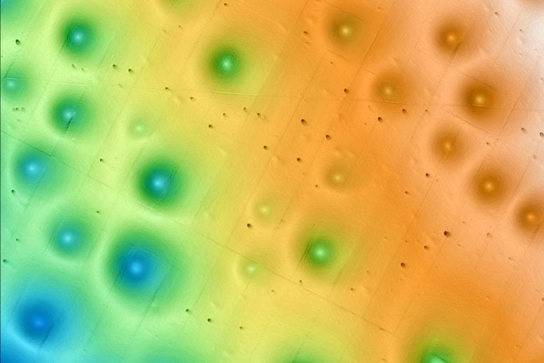
 New research on a field of pockmarks—large, circular depressions on the seafloor—offshore of Central California has revealed that powerful sediment flows, not methane gas eruptions, maintain these prehistoric formations. This work by a team of researchers from MBARI, USGS, and Stanford University provides important information to guide decision-making about responsible use and management of the seafloor off California, including site assessments for the development of offshore wind farms. Credit: © 2019 MBARI
Researchers studying massive seafloor depressions off the Central California coast discovered that these pockmarks, once thought to be signs of methane eruptions, are actually sustained by ancient, powerful sediment flows.
This surprising finding upends previous assumptions and provides crucial guidance for safe offshore wind farm development.
Ancient Seafloor Pockmarks
Extensive research from the Monterey Bay Aquarium Research Institute (MBARI), in collaboration with the United States Geological Survey (USGS) and Stanford University, has uncovered a surprising origin story for thousands of strange circular depressions on the ocean floor off Central California. These formations, called pockmarks, were once thought to be created by methane gas erupting from beneath the seabed. But the latest findings point to something even more dramatic: massive, ancient underwater sediment flows.
The team’s results, published in the Journal of Geophysical Research: Earth Surface, are helping scientists and resource managers better understand the stability of the seafloor. That information is especially important now, as California plans for offshore wind farms in the same region.
 Located offshore of Central California, the Sur Pockmark Field contains more than 5,200 circular depressions. Credit: Eve Lundsten © 2024 MBARI
Vast Seafloor Depression Field Raises Concerns
Just off the coast of Big Sur lies the Sur Pockmark Field, an area the size of Los Angeles that contains more than 5,200 of these deep, circular pits. Each one spans about 200 meters wide, roughly the length of two football fields, and plunges five meters deep. Until now, many believed these giant depressions were formed by methane gas bubbles rising through the seafloor. With clean energy projects on the horizon, experts were concerned that methane could pose risks to seafloor stability and infrastructure.
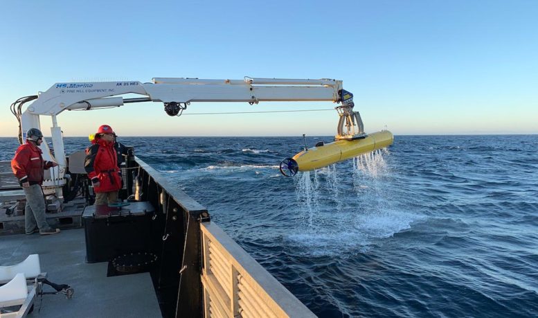
 MBARI’s advanced underwater robots allowed researchers to map the Sur Pockmark Field and visualize the layers of sediment below some of the individual pockmarks. Credit: Dave Caress © 2019 MBARI
No Methane Detected: Gravity Flows Identified as Key Force
However, MBARI’s advanced ocean research tools told a different story. The team found no signs of methane. Instead, their data revealed that powerful sediment flows—mud, sand, and water rushing downhill along the seafloor like underwater avalanches—have been shaping and maintaining these formations for hundreds of thousands of years.
“There are many unanswered questions about the seafloor and its processes,” said MBARI Senior Research Technician Eve Lundsten, who led this work. “This research provides important data about the seafloor for resource managers and others considering potential offshore sites for underwater infrastructure to guide their decision-making.”
 Researchers examined sediment samples to reconstruct the history of individual pockmarks. Credit: Eve Lundsten © 2018 MBARI
High-Tech Mapping and Sampling Reveal Seafloor Secrets
The research team deployed MBARI’s advanced underwater robots to study the Sur Pockmark Field. First, autonomous underwater vehicles (AUVs)—torpedo-shaped, self-guided robots—mapped the region. Previous maps of the seafloor were collected by sonar mounted on ships, but the distance between the ocean surface and the seafloor resulted in low-resolution data. AUVs can travel closer to the seafloor to visualize the terrain below in much greater detail. MBARI’s seafloor mapping AUVs also carried technology to profile the sub-bottom layers of sediment below the seafloor. These maps then guided sampling with MBARI’s remotely operated vehicle (ROV) Doc Ricketts. Operated by the research team in the control room aboard an MBARI research vessel, the ROV Doc Ricketts collected sediment samples to reconstruct the history of individual pockmarks.
These pockmarks are located on the continental margin, a dynamic section of the seafloor that connects the relatively shallow continental shelf to the deep sea. Sediment gravity flows can move massive amounts of material through this region intermittently. The data and samples collected by MBARI technology helped the research team piece together the history of sediment movements over this part of the seafloor.
 MBARI’s Continental Margin Processes Team collaborated with researchers from USGS and Stanford University to better understand prehistoric pockmark formations on the seafloor offshore of Central California. Credit: Nora Nieminski/USGS
Evidence of Ancient Turbidite Flows Preserving Pockmarks
The team found multiple layers of sandy deposits, called turbidites, in the sediment samples taken from the pockmarks and the sub-bottom images of the pockmark field. These deposits indicated that large sediment gravity flows in the region have occurred intermittently for at least the last 280,000 years. These sediment gravity flows appear to cause erosion in the center of each pockmark, maintaining these unique underwater morphologic features over time.
“We collected a massive amount of data, allowing us to make a surprising link between pockmarks and sediment gravity flows. We were unable to determine exactly how these pockmarks were initially formed, but with MBARI’s advanced underwater technology, we’ve gained new insight into how and why these features have persisted on the seafloor for hundreds of thousands of years,” said Lundsten.
 MBARI’s mapping AUV collected bathymetry of the present-day seafloor of the Sur Pockmark Field. Acoustic technology on the AUV also allowed researchers to visualize the sediment layers underneath that were deposited over thousands of years. Credit: Eve Lundsten © 2024 MBARI
Global Relevance: Pockmarks and Offshore Wind Risks
Seafloor pockmarks have been found elsewhere around the world. In those locations, pockmarks have been associated with the release of methane gas or other fluids from the seafloor. Bubbling methane could potentially cause the seafloor to be unstable, which could pose risks for structures on the seafloor, like the anchors for offshore wind turbines. In October 2018, the U.S. Bureau of Ocean Energy Management (BOEM) announced areas offshore of Central California for potential wind energy leasing. MBARI quickly moved to conduct this research to answer critical questions about the stability of the seafloor to guide development of offshore wind energy in California.
“Expanding renewable energy is critical to achieving the dramatic cuts in carbon dioxide emissions needed to prevent further irreversible climate change. However, there are still many unanswered questions about the possible environmental impacts of offshore wind energy development,” said MBARI President and CEO Chris Scholin. “This research is one of many ways that MBARI researchers are answering fundamental questions about our ocean to help inform decisions about how we use marine resources.”
 Sediment cores collected throughout the pockmark field contained coarse, sandy deposits called turbidites (revealed in red by a CT scan on the left and clearly visible in the core photograph on the right), indicative of large sediment flows. These deposits correlate with the layers seen in the sub-bottom profiles (black-and-white inset) collected by MBARI’s mapping robots, suggesting massive layers of sand have occasionally blanketed the entire Sur Pockmark Field. Credit: Eve Lundsten © 2024 MBARI
EXPRESS Campaign Enhances Understanding of West Coast Seafloor
Because of the extensive efforts of MBARI, USGS, BOEM, and NOAA as part of the interagency Expanding Pacific Research and Exploration of Submerged Systems (EXPRESS) cooperative research campaign, the Sur Pockmark Field is now one of the best-studied areas of seafloor on the west coast of North America. However, there are still many questions to answer about these pockmarks, including how these features were initially formed hundreds of thousands of years ago.
Reference: “Pockmarks Offshore Big Sur, California Provide Evidence for Recurrent, Regional, and Unconfined Sediment Gravity Flows” by E. Lundsten, C. K. Paull, R. Gwiazda, S. Dobbs, D. W. Caress, L. A. Kuhnz, M. Walton, N. Nieminski, M. McGann, T. Lorenson, G. Cochrane and J. Addison, 21 May 2024, Journal of Geophysical Research: Earth Surface.
DOI: 10.1029/2023JF007374
Funding for this work was provided by the David and Lucile Packard Foundation, BOEM, and USGS.
A version of this article was originally published in May 2024.
Never miss a breakthrough: Join the SciTechDaily newsletter.
.png)


/cdn.vox-cdn.com/uploads/chorus_asset/file/8791797/17776social.0.jpg)

