Thanks to GO, Transit app riders are now crowdsourcing better bus and train data in 900+ cities — and helping their hometown agencies make service improvements
If you’re riding public transit in North America or Europe, there’s a good chance someone onboard is using Transit to share your bus or train’s current location.
Which is good news.
Because while many transit systems publish real-time data for all the vehicles in their network, plenty of others don’t:
In Paris and Brussels, Lyon and Manchester, Barcelona and Stockholm, real-time vehicle locations aren’t accessible
On Montreal’s metro, Vancouver’s Skytrain and Calgary’s CTrain, neither train locations nor predicted arrival times are accessible
Real-time data for Vancouver’s Skytrain isn’t available, but the city’s many Transit app riders fill in the gaps on ~50,000 Skytrain trips each month.
And while many agencies have made huge strides in real-time data quality— there’s still no guarantee that their “real-time” data will be up-to-the-second.
Sometimes it’s not even up-to-the-several-minutes-ago…
Most transit agency feeds take 30+ seconds to update their vehicle locations (note: some agencies have one feed, others have multiple). For razor-tight transfers and 100m sprints to the stop, this can be a matter of making the bus or not.
Public transit riders want real-time that’s actually real — without hiccups, lag, or vanishing vehicles.
To help agencies generate better real-time when their GPS transponders aren’t up to the task, we’ve empowered Transit riders to fill in the gaps. And fill in the gaps, they do!
How GO works
Your phone can send GPS locations far faster than the transmitters on buses and trains.
When you tap “GO” in Transit, you not only get step-by-step directions for your trip — you can also share your bus or train’s location with nearby riders.
And your phone’s real-time locations come with 1 or 2 seconds of latency, rather than with the 15 seconds of latency from your typical bus transponder.
Across billions of trips, those seconds add up.
A Transit app rider using “GO” sends vehicle locations to riders waiting downstream. GO data is typically more precise than the data we get from transit agencies.
The added precision is a gamechanger, especially if you’re waiting in the cold, chasing down a bus, deciding whether to give up, walk, order an Uber, or sprint to an alternative bus stop.
How we made GO mainstream
We first launched crowdsourcing for our hometown STM buses in December 2016 — it was our way of generating some real-time bus data in Montreal, back when it wasn’t available. A few weeks later, we launched it in San Francisco after Muni’s real-time feed broke. We gradually rolled it out to more cities, before launching GO crowdsourcing in all our supported cities in 2018.
There are now a lot more people using Transit than there were back in 2016.
More than 150 agencies have made Transit their official app with Royale, and countless others promote it as the best app for navigating their system.
Now, in largely bus-propelled cities like Ottawa-Gatineau, Vegas, Baltimore, and Victoria, GO riders are improving real-time data on up to 65% of all vehicle trips, and an even higher percentage during rush hour.
Here is what our internal GO tracking dashboard looks like for a given agency data feed. To turn these charts into a percentage of trips, we take the median number of vehicles being crowdsourced with GO every five minutes, then divide it by the median number of total vehicles in an agency’s real-time feed — then aggregate that data.
In cities with more rapid transit like Los Angeles, Philly, Montreal, and Vancouver, they’re improving data on up to 20% of all transit trips, and again, even more during rush hour.
(When you consider that your phone can’t send updates on many underground train trips? Those GO usage stats become even more impressive!)
How did we radicalize all those millions of bored bus riders and turn them into an army of city-saving, GO-using altruists?!?!
Gamification
Riders must “opt-in” to sharing their bus and train locations with downstream riders — we’re a privacy-first company, and we don’t collect user locations in the background unless you give us explicit permission.
Even in a city with good real-time data, those feeds will occasionally go down. When that happens, we remind riders to use GO — and they do, filling in the real-time gaps!
To that end, we’ve made GO utterly delightful to use — beyond just telling you when to leave for your stop, or where to disembark.
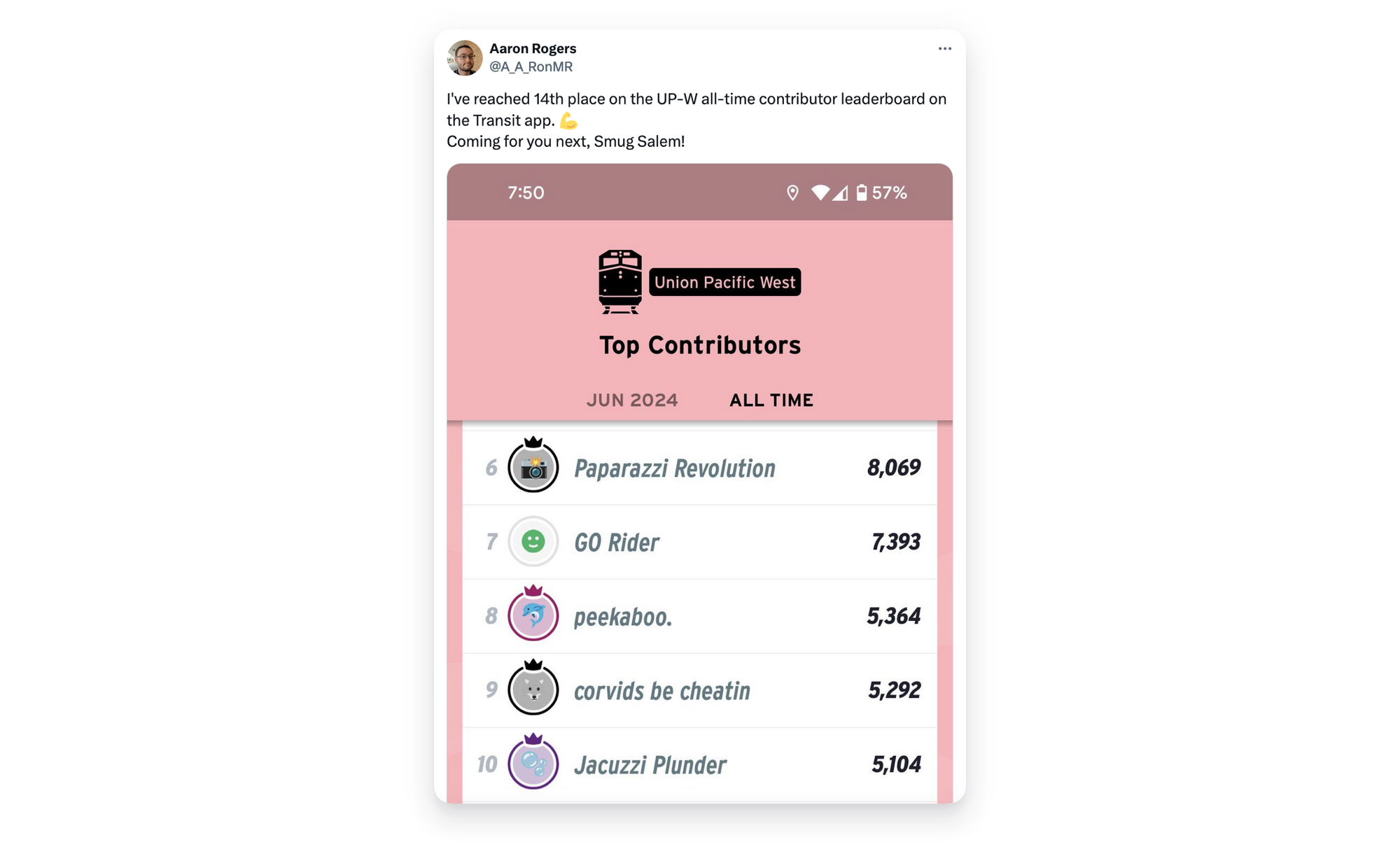
For starters, each transit line gets its own leaderboard. Riders compete with each other to be the most helpful rider on it. (Yes. We know. It sounds odd. But it’s addictingly fun.)
As soon as you start sharing your vehicle location, you’re showered in GO points for every nearby rider you help.
Riders check their leaderboards more than a million times per month.
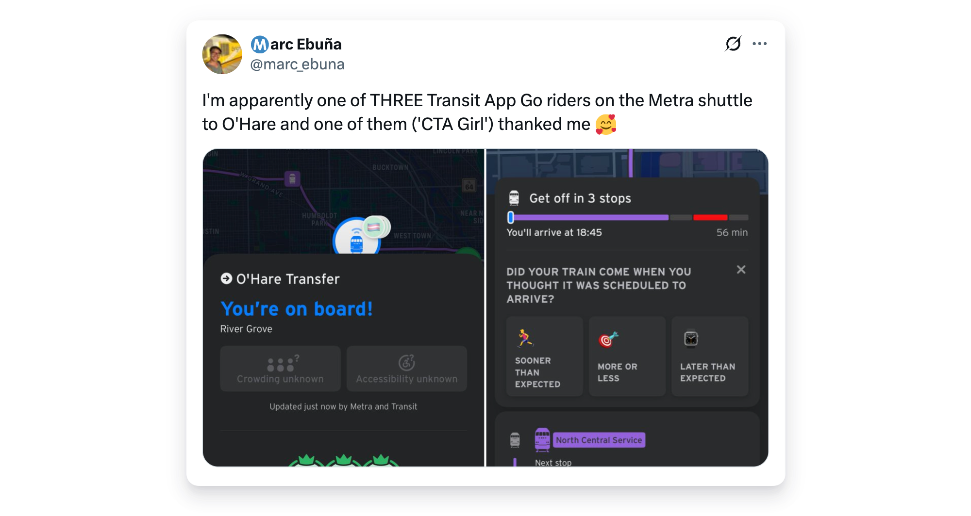
The dopamine pumps are primed further on each GO trip: riders who are waiting at the stop send millions of in-app “thank yous” to the folks upstream who are currently on the bus or train.
And because each GO rider has their own unique nickname and emoji, each of those “thank yous” comes with a personal touch.
They’re little design details, but they make riders feel gratified for volunteering their time and kilobytes to the cause. On in-app surveys, 20% of Transit riders say they use GO specifically for the gamification features.
Millions of GO trips later, billions of riders helped, we’ve figured out a recipe that keeps riders GOing.
Engagement
With millions of riders using GO on their daily commute, we realized there might be an opportunity to gather more than just vehicle locations.
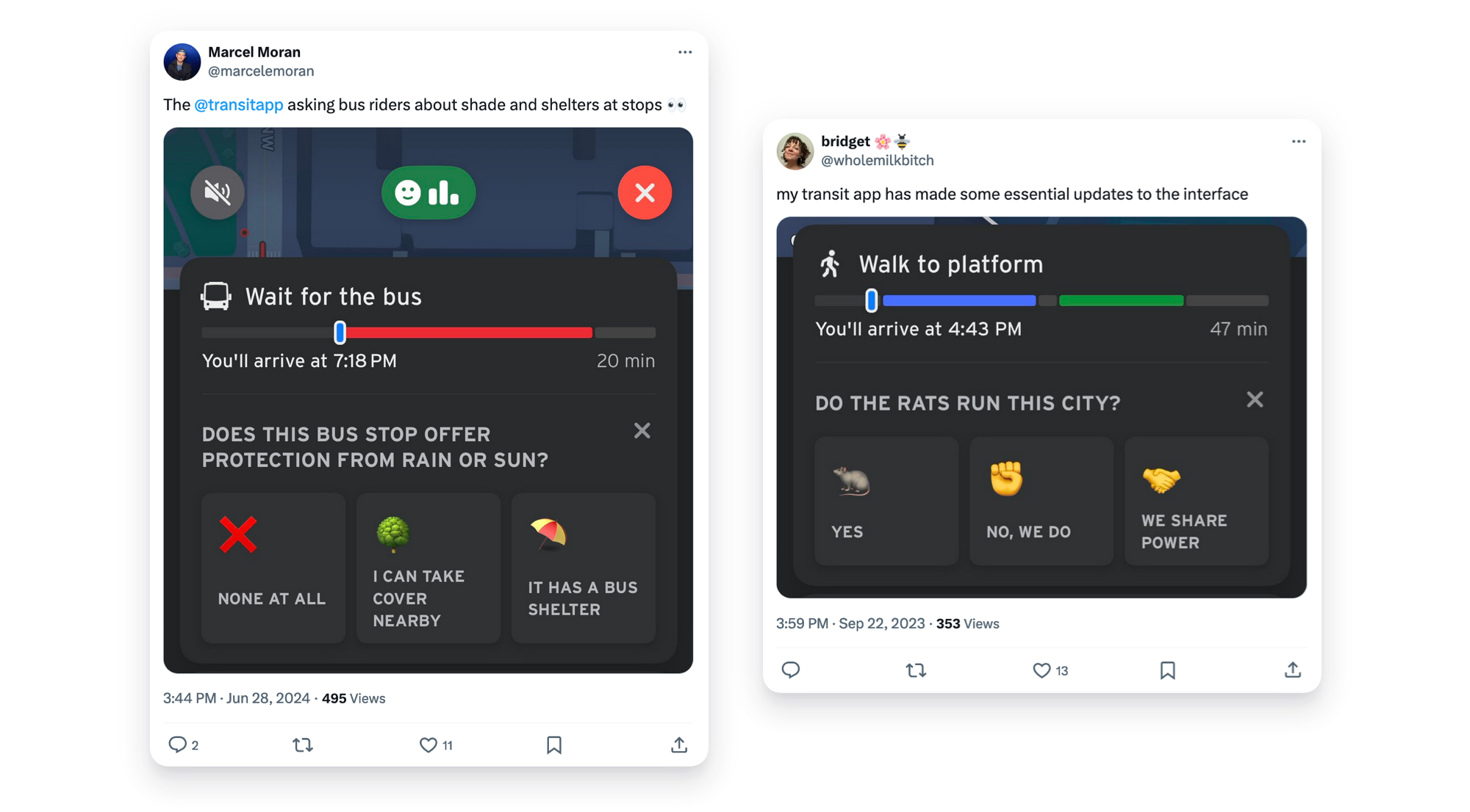
Maybe we could ask riders for feedback on their trip — then use that data to improve transit service on the ground?
Is the vehicle crowded? Did the train come when you expected it? Did your bus stop have seats and shelter? Is your stop too dark? Blocked by snow? Did you see any rats on the subway?
We get 10 million rider responses each month, and share the data back (anonymously) with our transit agency partners and our users, letting them see which lines are chronically late or crowded, for instance.
Equipped with our data, their staff can swoop in to review specific lines, stops, and trips.
Before Rate-My-Ride, and after Rate-My-Ride, at Santa Monica Boulevard and Westgate Avenue. Photos: Big Blue Bus
Now we’re generating even more GO trips, with AutoGO
From leaderboards to thank yous, we’re always thinking up new ways to enchant our riders to use GO more often.
Before, riders would have to discover GO themselves, by playing around with the app — either planning an a-to-b trip, or tapping on a specific transit line.
But what if you didn’t need to?
What if we could match you to a vehicle — automatically?
Our data doctors Marisa, Quentin, and Ayser cooked up the solution: now, as soon as you open Transit, we’ll guess which nearby bus you’re on. If we’ve guessed correctly, you’ll be prompted to start a GO trip immediately. Move over Shazam. Hello AutoGO.
It removes the learning curve for GO, and means even more riders are now volunteering real-time vehicle locations. Over 1M GO trips have now been started through AutoGO.
Rider by rider, design tweak by tweak, the number of vehicles covered by GO riders is getting bigger every year.
Is there a world where an app can paint you a perfect real-time portrait of your city’s transit vehicles? Maybe not.
But if there is, it’ll be thanks to riders helping riders.
.png)


 Real-time data for Vancouver’s Skytrain isn’t available, but the city’s many Transit app riders fill in the gaps on ~50,000 Skytrain trips each month.
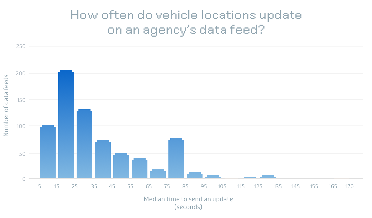 Most transit agency feeds take 30+ seconds to update their vehicle locations (note: some agencies have one feed, others have multiple). For razor-tight transfers and 100m sprints to the stop, this can be a matter of making the bus or not.
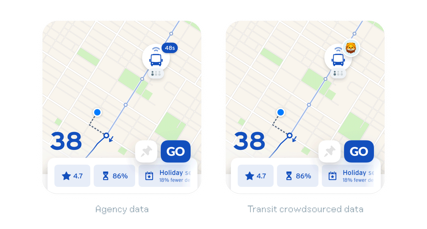 A Transit app rider using “GO” sends vehicle locations to riders waiting downstream.


 Here is what our internal GO tracking dashboard looks like for a given agency data feed. To turn these charts into a percentage of trips, we take the median number of vehicles being crowdsourced with GO every five minutes, then divide it by the median number of total vehicles in an agency’s real-time feed — then aggregate that data.

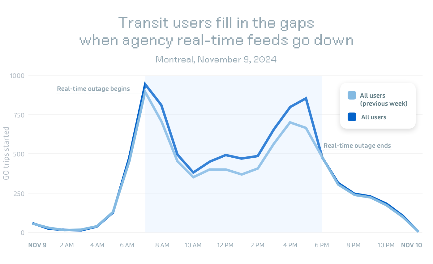 Even in a city with good real-time data, those feeds will occasionally go down. When that happens, we remind riders to use GO — and they do, filling in the real-time gaps!

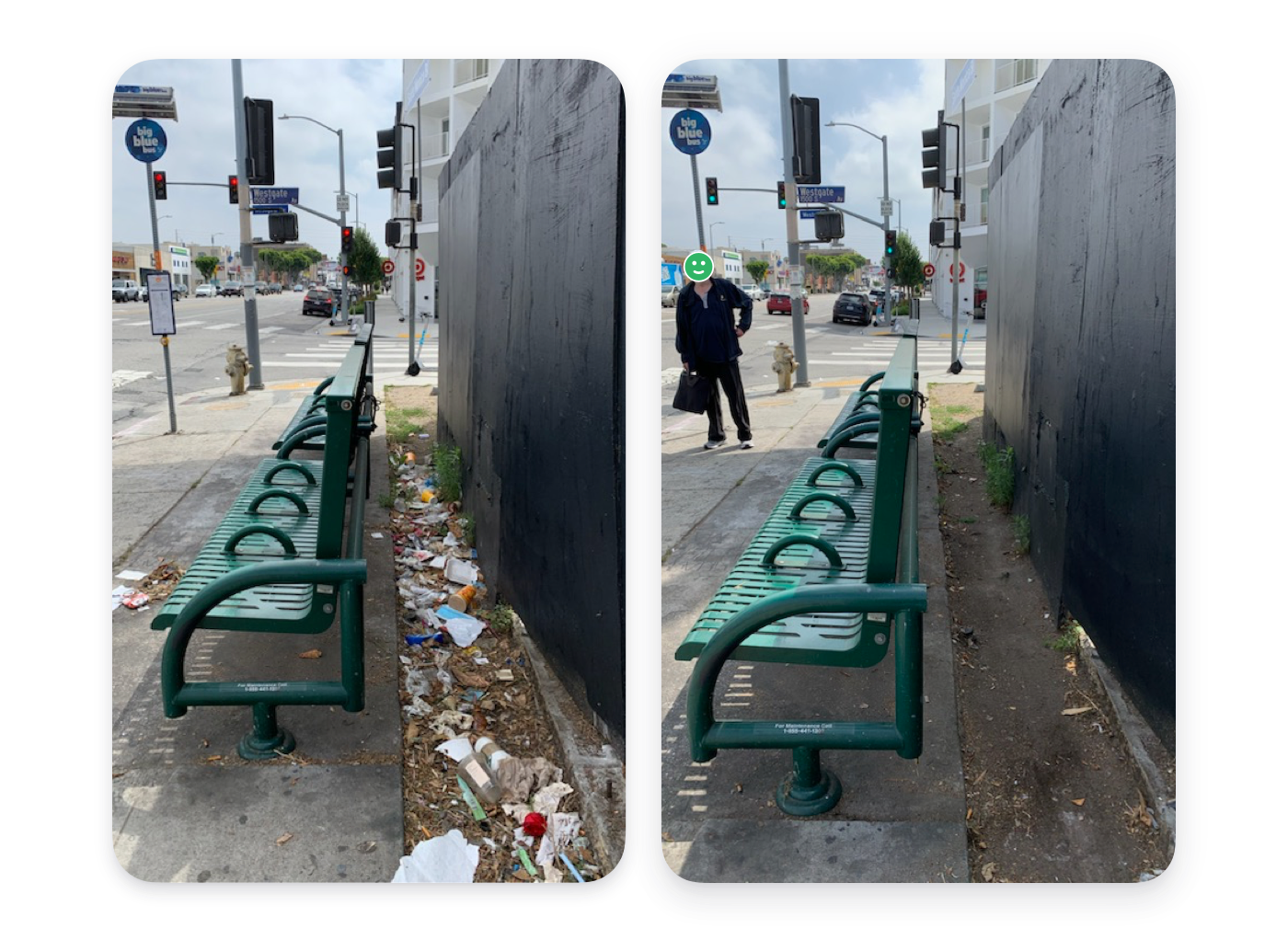 Before Rate-My-Ride, and after Rate-My-Ride, at Santa Monica Boulevard and Westgate Avenue.